Login
Register


ORL
Exec Airport
Official FAA Data Effective 2024-03-21 0901Z
Chart Supplement

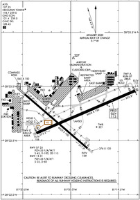
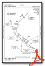
KORL Airport Diagram
VFR Chart of KORL
Sectional Charts at SkyVector.com
IFR Chart of KORL
Enroute Charts at SkyVector.com
Location Information for KORL
Coordinates: N28°32.73' / W81°19.98'Located 03 miles E of Orlando, Florida on 969 acres of land. View all Airports in Florida.
Surveyed Elevation is 112 feet MSL.
Operations Data
|
|
Airport Communications
| ATIS: | 127.25 |
|---|---|
| ASOS: | 127.25 Tel. 407-658-6753 |
| EXECUTIVE TOWER: | 118.7 239.0 |
| EXECUTIVE GROUND: | 121.4 239.0 |
| ORLANDO APPROACH: | 119.4 ;181-310 5500 FT & BLW 119.4 ;SOUTHWEST 119.775 ;061-180 4500 FT & BLW 120.15 ;181-359 ABV 5500 FT 124.8 ;000-180 ABV 5000 FT 135.3 ;311-060 5500 FT & BLW 351.9 ;5500 FT & BLW |
| ORLANDO DEPARTURE: | 119.4 ;181-310 5500 FT & BLW 119.4 ;SOUTHWEST 119.775 ;061-180 4500 FT & BLW 120.15 ;181-359 ABV 5500 FT 124.8 ;000-180 ABV 5000 FT 135.3 ;311-060 5500 FT & BLW 351.9 ;5500 FT & BLW |
| IC: | 124.8 ;000-180 ABV 5000 FT |
| CLEARANCE DELIVERY: | 128.45 |
| ALYNA STAR: | 124.8 307.0 |
| JAFAR STAR: | 134.05 339.8 |
| MINEE STAR: | 134.05 339.8 |
| EMERG: | 121.5 243.0 |
| PRICY STAR: | 134.05 339.8 |
| RIDES STAR: | 128.375 338.2 |
| NYTES DP: | 119.775 351.9 |
| GOOFY STAR: | 124.8 128.375 338.2 |
| LEESE STAR: | 128.675 263.05 134.05 339.8 |
| CTAF: | 118.700 |
| SHREK STAR: | 128.675 263.05 134.05 339.8 |
| UNICOM: | 122.950 |
| TTHOR STAR: | 118.85 353.825 119.775 351.9 |
| TOLLZ DP: | 119.4 351.9 |
| CWRLD STAR: | 307.0 |
| AMEND STAR: | 339.8 |
| JOKRS STAR: | 134.05 339.8 |
| D-ATIS at MCO (7.1 S): | 121.25 ;ARR |
| ASOS at MCO (7.4 S): | 407-855-5235 |
| ASOS at SFB (14.8 N): | 125.975 407-321-9384 |
Nearby Navigation Aids
|
| ||||||||||||||||||||||||||||||||||||||||||


Runway 07/25
| Dimensions: | 6004 x 150 feet / 1830 x 46 meters | |
|---|---|---|
| Surface: | Asphalt / Grooved in Fair Condition | |
| Weight Limits: | 55 /F/A/W/T, S-45, D-100, ST-115 | |
| Edge Lighting: | High Intensity | |
| Runway 07 | Runway 25 | |
| Coordinates: | N28°32.57' / W81°20.36' | N28°32.96' / W81°19.33' |
| Elevation: | 105.6 | 109.7 |
| Traffic Pattern: | Left | Right |
| Runway Heading: | 67° True | 247° True |
| Declared Distances: | TORA:6004 TODA:6004 ASDA:5604 LDA:5604 | TORA:6004 TODA:6004 ASDA:6004 LDA:6004 |
| Markings: | Precision Instrument in good condition. | Precision Instrument in good condition. |
| Glide Slope Indicator | P2L (3.00° Glide Path Angle) | P4R (3.00° Glide Path Angle) |
| RVR Equipment | Touchdown | Rollout |
| Approach Lights: | MALSR 1,400 Foot Medium-intensity Approach Lighting System with runway alignment indicator lights. | |
| Obstacles: | 41 ft Trees 1605 ft from runway, 420 ft left of center | |
Runway 13/31
| Dimensions: | 4625 x 100 feet / 1410 x 30 meters | |
|---|---|---|
| Surface: | Asphalt / Grooved in Fair Condition | |
| Weight Limits: | 35 /F/B/X/T, S-35, D-60 | |
| Edge Lighting: | High Intensity | |
| Runway 13 | Runway 31 | |
| Coordinates: | N28°32.93' / W81°20.48' | N28°32.43' / W81°19.82' |
| Elevation: | 104.0 | 109.0 |
| Traffic Pattern: | Left | Right |
| Runway Heading: | 131° True | 311° True |
| Markings: | Basic in fair condition. | Basic in fair condition. |
| Glide Slope Indicator | P2L (3.00° Glide Path Angle) | P2L (3.00° Glide Path Angle) |
| REIL: | Yes | Yes |
| Obstacles: | 49 ft Trees 1890 ft from runway, 150 ft right of center | 53 ft Tree 1303 ft from runway, 15 ft right of center |
Services Available
| Fuel: | 100 (green), 100LL (blue), Jet-A |
|---|---|
| Transient Storage: | Hangars,Tiedowns |
| Airframe Repair: | MAJOR |
| Engine Repair: | MAJOR |
| Bottled Oxygen: | LOW |
| Bulk Oxygen: | NONE |
| Other Services: | AIR FREIGHT SERVICES,AIR AMBULANCE SERVICES,AVIONICS,CARGO HANDLING SERVICES,CHARTER SERVICE,PILOT INSTRUCTION,AIRCRAFT RENTAL,AIRCRAFT SALES,ANNUAL SURVEYING |
Ownership Information
| Ownership: | Publicly owned | |
|---|---|---|
| Owner: | GREATER ORLANDO AVIATION AUTH | ARPT MAIN OFC CTC 407-825-1699; 24/7 EMERG CTC 407 579-5088. |
| 1 JEFF FUQUA BLVD | ||
| ORLANDO, FL 32827-4399 | ||
| 407-825-1699 | ||
| Manager: | JUDITH-ANN JARRETTE | |
| 365 RICKENBACKER DR | ||
| ORLANDO, FL 32803 | ||
| 407-825-1683 | ||
Operational Statistics
| Single Engine Aircraft Based on Field: | 155 | Statistics collected for 12 month period ending 2022-07-31 | |
|---|---|---|---|
| Multi-Engine Aircraft Based on Field: | 47 | Annual Commercial Operations: | 12 |
| Jet Aircraft Based on Field: | 36 | Annual Commuter Operations: | none |
| Helicopters Based on Field: | 19 | Annual Air Taxi Operations: | 8410 |
| Military Aircraft Based on Field: | none | Annual Military Operations: | none |
| Gliders Based on Field: | 1 | Annual GA Local Operations: | 76159 |
| Ultralights Based on Field: | 1 | Annual GA Itinerant Operations: | 72575 |
Other Remarks
- PPR FOR ACFT OVER 100000 LBS; CTC AMGR 407-825-1683.
- CBP OFC LCTD ONSITE PPR. CTC 407 825-5102. BE ALERT: CBP BOX LCTD ON EAST RAMP IS RSTRD.
- EXECUTIVE ARPT VFR ARR/DEP EXERCISE CAUTION DUE TO SMALL & HVY TURBO-JET ACFT TRANSITING ARPT TFC AREA 2000 FT & ABOVE ON APCH TO ORLANDO INTL 5.6 NM S.
- TWY E BTW TWY E5 & E6 IS NON MOVEMENT AREA. ARFF ON FIELD; NO INDEX.
- CALL BOXES MKD NEAR ENTRANCES TO W, N & E RAMPS.
- LGTD BRIDGE HWY LCTD 0.5 NM S OF ARPT MAY GIVE FALSE INDCN OF APCH TO RWY 07 & 31.
- WILDLIFE INVOF ARPT.
- FOR CD OR TO CNL IFR WHEN ATCT IS CLSD, CTC ORLANDO APCH AT 407-852-7500.
- NOISE SENSITIVE ARPT. WHEN ATCT CLSD RWY 07 IS PREF NOISE ABATEMENT RWY WX PMTG. VOLUNTARY RESTRAINT FROM TGL OPS 2300 - 0700.
- BANNER TOWING OPS S RWY 07/25.
- ACFT TAXI ON S HALF OF THE W RAMP RESTR TO ADG1.
- ATC RADAR REQ WHEN ORL ILS RWY 7 & MCO ILS RWY 17 & 18R SIMULTANEOUS OPS ARE CONDUCTED.
- WHEN ATCT CLSD ACTVT MALSR RWY 07; REIL RWY 13 & 31; HIRL RWY 07/25 & 13/31; TWY LGTS - CTAF.
Weather Minimums
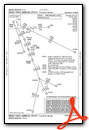
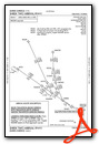
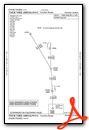
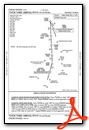
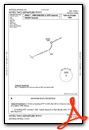
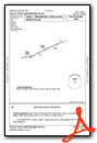
Standard Terminal Arrival (STAR) Charts
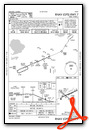
- ALYNA FOUR (RNAV)
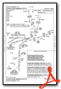
- GOOFY SEVEN
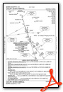
- JAFAR THREE (RNAV)
- JAFAR THREE (RNAV), CONT.1
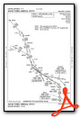
- JOKRS THREE (RNAV)
- JOKRS THREE (RNAV), CONT.1
- LEESE THREE
- LEESE THREE, CONT.1
- MINEE FIVE
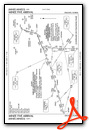
- MINEE FIVE, CONT.1
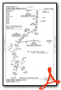
- PRICY THREE (RNAV)
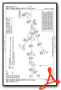
- PRICY THREE (RNAV), CONT.1
- PRICY THREE (RNAV), CONT.2
- RIDES TWO (RNAV)
- RIDES TWO (RNAV), CONT.1
- RIDES TWO (RNAV), CONT.2
- SHREK TWO (RNAV)
- TTHOR THREE (RNAV)
- TTHOR THREE (RNAV), CONT.1
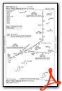
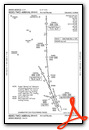
Instrument Approach Procedure (IAP) Charts
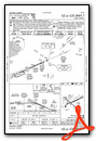
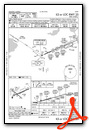
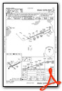
Departure Procedure (DP) Charts
Nearby Airports with Instrument Procedures
| ID | Name | Heading / Distance | ||
|---|---|---|---|---|
 |
KMCO | Orlando International Airport | 169° | 7.1 |
|
KSFB | Orlando Sanford International Airport | 020° | 14.8 |
|
KISM | Kissimmee Gateway Airport | 199° | 16.3 |
|
X04 | Orlando Apopka Airport | 306° | 16.3 |
|
X21 | Arthur Dunn Air Park Airport | 079° | 26.7 |
|
KTIX | Space Coast Regional Airport | 093° | 28.3 |
|
X23 | Umatilla Municipal Airport | 323° | 28.2 |
|
KLEE | Leesburg International Airport | 303° | 30.1 |
|
KDED | Deland Municipal-Sidney H Taylor Field Airport | 004° | 31.3 |
|
X50 | Massey Ranch Airpark Airport | 039° | 33.7 |
|
KTTS | Space Florida Launch and Landing Facility Airport | 082° | 34.0 |
|
7FL6 | Spruce Creek Airport | 025° | 35.4 |
Fuel Providers


We proudly offer fuel from:

US Dollar per US Gallon
Price Guaranteed by FBO
Airport Images
Do you have a recent image of this airport? Upload it here!


