Login
Register


OSH
Wittman Regional Airport
Official FAA Data Effective 2024-04-18 0901Z
Chart Supplement

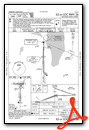
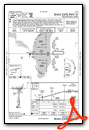
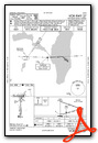
KOSH Airport Diagram

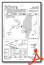
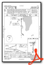
VFR Chart of KOSH
Sectional Charts at SkyVector.com
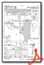
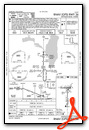
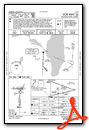
IFR Chart of KOSH
Enroute Charts at SkyVector.com
Location Information for KOSH
Coordinates: N43°59.06' / W88°33.42'Located 02 miles S of Oshkosh, Wisconsin on 1392 acres of land. View all Airports in Wisconsin.
Surveyed Elevation is 808 feet MSL.
Operations Data
|
|
Airport Communications
| ATIS: | 125.9 |
|---|---|
| ASOS: | Tel. 920-426-1644 |
| OSHKOSH TOWER: | 118.5 290.9 |
| OSHKOSH GROUND: | 132.3 |
| MILWAUKEE APPROACH: | 127.0 263.075 |
| MILWAUKEE DEPARTURE: | 127.0 263.075 |
| UNICOM: | 122.950 |
| CTAF: | 118.500 |
| EMERG: | 121.5 243.0 |
| ASOS at FLD (13.1 S): | 134.0 920-922-4444 |
| AWOS-3 at ATW (16.1 N): | 920-832-2597 |
| ATIS at ATW (16.5 N): | 127.15 |
Nearby Navigation Aids
|
| ||||||||||||||||||||||||||||||||||||||||||||||||||||||||||||


Runway 18/36
| Dimensions: | 8002 x 150 feet / 2439 x 46 meters | |
|---|---|---|
| Surface: | Concrete / Grooved in Good Condition | |
| Weight Limits: | S-65, D-85, ST-130 | |
| Edge Lighting: | High Intensity | |
| Runway 18 | Runway 36 | |
| Coordinates: | N43°59.15' / W88°33.39' | N43°57.83' / W88°33.40' |
| Elevation: | 789.6 | 808.4 |
| Traffic Pattern: | Left | Left |
| Runway Heading: | 181° True | 1° True |
| Markings: | Precision Instrument in good condition. | Precision Instrument in good condition. |
| Glide Slope Indicator | P4L (3.00° Glide Path Angle) | P4L (3.00° Glide Path Angle) |
| RVR Equipment | Rollout | Touchdown |
| Approach Lights: | MALSR 1,400 Foot Medium-intensity Approach Lighting System with runway alignment indicator lights. | |
| REIL: | Yes | |
| Obstacles: | 15 ft Antenna 550 ft from runway, 250 ft left of center | |
Runway 09/27
| Dimensions: | 6179 x 150 feet / 1883 x 46 meters | |
|---|---|---|
| Surface: | Concrete / Grooved in Good Condition | |
| Weight Limits: | S-75, D-125, ST-185 | |
| Edge Lighting: | High Intensity | |
| Runway 09 | Runway 27 | |
| Coordinates: | N43°59.50' / W88°34.33' | N43°59.49' / W88°32.92' |
| Elevation: | 797.5 | 775.8 |
| Traffic Pattern: | Left | Left |
| Runway Heading: | 91° True | 271° True |
| Displaced Threshold: | 531 Feet | |
| Declared Distances: | TORA:6179 TODA:6179 ASDA:5648 LDA:5648 | TORA:6179 TODA:6179 ASDA:6179 LDA:5648 |
| Markings: | Non-Precision Instrument in good condition. | Non-Precision Instrument in good condition. |
| Glide Slope Indicator | P4L (3.00° Glide Path Angle) | P4L (3.00° Glide Path Angle) |
| REIL: | Yes | |
| Obstacles: | 39 ft Tree 750 ft from runway, 160 ft right of center APCH RATIO 34:1 TO DSPLCD THR. |
|
Runway 05/23
| Dimensions: | 3424 x 75 feet / 1044 x 23 meters | |
|---|---|---|
| Surface: | Asphalt in Fair Condition | |
| Runway 05 | Runway 23 | |
| Coordinates: | N43°59.20' / W88°33.50' | N43°59.60' / W88°32.95' |
| Elevation: | 790.3 | 775.2 |
| Traffic Pattern: | Left | Left |
| Runway Heading: | 45° True | 225° True |
| Markings: | Basic in good condition. | Basic in good condition. |
Runway 13/31
| Dimensions: | 3061 x 75 feet / 933 x 23 meters | |
|---|---|---|
| Surface: | Asphalt in Fair Condition | |
| Runway 13 | Runway 31 | |
| Coordinates: | N43°59.47' / W88°33.58' | N43°59.15' / W88°33.04' |
| Elevation: | 781.7 | 781.2 |
| Traffic Pattern: | Left | Left |
| Runway Heading: | 129° True | 309° True |
| Markings: | Basic in good condition. | Basic in good condition. |
| Obstacles: | 15 ft Road 217 ft from runway, 127 ft right of center | |
Services Available
| Fuel: | 100LL (blue), Jet A+ |
|---|---|
| Transient Storage: | Hangars,Tiedowns |
| Airframe Repair: | MAJOR |
| Engine Repair: | MAJOR |
| Bottled Oxygen: | NONE |
| Bulk Oxygen: | HIGH/LOW |
| Other Services: | AIR FREIGHT SERVICES,AVIONICS,CARGO HANDLING SERVICES,CHARTER SERVICE,PILOT INSTRUCTION,AIRCRAFT RENTAL,AIRCRAFT SALES |
Ownership Information
| Ownership: | Publicly owned | |
|---|---|---|
| Owner: | WINNEBAGO COUNTY | |
| 415 JACKSON ST | ||
| OSHKOSH, WI 54901 | ||
| 920-236-4930 | ||
| Manager: | JAMES SCHELL | |
| 525 W 20TH AVE | EMAIL ADDRESS: JSCHELL@WINNEBAGOCOUNTYWI.GOV (ALL LOWER CASE). | |
| OSHKOSH, WI 54902 | ||
| 920-236-4930 | ||
Operational Statistics
| Single Engine Aircraft Based on Field: | 129 | Statistics collected for 12 month period ending 2021-12-31 | |
|---|---|---|---|
| Multi-Engine Aircraft Based on Field: | 27 | Annual Commercial Operations: | none |
| Jet Aircraft Based on Field: | 11 | Annual Commuter Operations: | none |
| Helicopters Based on Field: | 1 | Annual Air Taxi Operations: | 2281 |
| Military Aircraft Based on Field: | none | Annual Military Operations: | 420 |
| Gliders Based on Field: | none | Annual GA Local Operations: | 36185 |
| Ultralights Based on Field: | none | Annual GA Itinerant Operations: | 41216 |
Other Remarks
- FOR CD IF UNA TO CTC ON FSS FREQ, CTC CHICAGO ARTCC AT 630-906-8921.
- SFC CONDS NOT MONTRD BTWN 2200 - 0500 HRS.
- BIRDS ON & INVOF ARPT.
- RWYS 13/31, 05/23 & TWYS C, H, P NOT AVBL TO ACFT WITH MORE THAN 30 PSGR SEATS.
- RY 23 & RY 27 APCH ENDS ARE CLOSELY ALIGNED. VERIFY CORRECT RY AND COMPASS HEADING PRIOR TO DEP.
- A+ AND 100LL AVBL 0700-1900++ MON-FRI, 0800-1700++ SAT-SUN, C920-236-7827 (AFTER HRS FEE $50).
- ACTVT MALSR RWY 36; HIRL RWY 09/27 - CTAF. HIRL 18/36 PRESET ON MED INTST, TO INCR INTST & ACTVT - CTAF. PAPI RWY 09, 27, 18 & 36 OPR CONSLY.
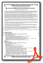
Weather Minimums
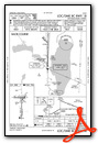
Instrument Approach Procedure (IAP) Charts

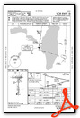
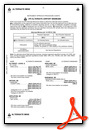
Nearby Airports with Instrument Procedures
| ID | Name | Heading / Distance | ||
|---|---|---|---|---|
 |
KFLD | Fond Du Lac County Airport | 166° | 13.1 |
|
KATW | Appleton International Airport | 005° | 16.5 |
|
8D1 | New Holstein Municipal Airport | 097° | 19.3 |
|
KPCZ | Waupaca Municipal Airport | 316° | 28.9 |
|
Y50 | Wautoma Municipal Airport | 276° | 32.6 |
|
KSBM | Sheboygan County Memorial Airport | 112° | 33.2 |
|
KUNU | Dodge County Airport | 190° | 34.1 |
|
KGRB | Green Bay/Austin Straubel International Airport | 031° | 35.2 |
|
KCLI | Clintonville Municipal Airport | 348° | 38.5 |
|
KETB | West Bend Municipal Airport | 150° | 38.6 |
|
KHXF | Hartford Municipal Airport | 169° | 38.7 |
|
KMTW | Manitowoc County Airport | 076° | 38.9 |
Airport Images

By: WisDOT Aeronautics


Comments
EAA Oshkosh Airventure FlyIn
Every July this is the best of the best airshows and fly ins in the world. Now if I could just figure out how to get that fuel truck to stop when I am near the airplane in the North 40...