Login
Register


OSU
Ohio State University Airport
Official FAA Data Effective 2024-04-18 0901Z
From the Flight Deck
Chart Supplement

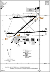
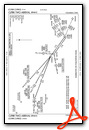
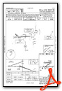
KOSU Airport Diagram
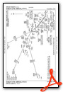
VFR Chart of KOSU
Sectional Charts at SkyVector.com
IFR Chart of KOSU
Enroute Charts at SkyVector.com
Location Information for KOSU
Coordinates: N40°4.77' / W83°4.39'Located 10 miles NW of Columbus, Ohio on 1080 acres of land. View all Airports in Ohio.
Surveyed Elevation is 905 feet MSL.
Operations Data
|
|
Airport Communications
| ATIS: | 121.35 |
|---|---|
| ASOS: | 121.35 Tel. 614-451-2465 |
| STATE TOWER: | 118.8 254.325 |
| STATE GROUND: | 121.7 |
| COLUMBUS APPROACH: | 125.95 317.775 |
| COLUMBUS DEPARTURE: | 125.95 317.775 |
| IC: | 125.95 317.775 |
| CLEARANCE DELIVERY: | 121.7 |
| CTAF: | 118.800 |
| NG OPS: | 123.075 46.8FM |
| CBUSS STAR: | 125.95 371.975 |
| UNICOM: | 122.950 |
| DUBLN STAR: | 125.95 371.975 |
| D-ATIS at CMH (9.7 SE): | 124.6 |
| ASOS at CMH (9.8 SE): | 124.6 614-338-4083 |
| AWOS-3PT at TZR (11.1 S): | 135.925 614-878-1722 |
- EMERG FREQ NOT AVBL.
- ATCT OPERATED BY MIDWEST INC.
Nearby Navigation Aids
|
| ||||||||||||||||||||||||||||||||||||||||||||||||||||||||||||


Runway 09R/27L
| Dimensions: | 5004 x 100 feet / 1525 x 30 meters | |
|---|---|---|
| Surface: | Asphalt / Grooved in Good Condition | |
| Weight Limits: | 17 /F/B/X/T, S-45, D-60 | |
| Edge Lighting: | High Intensity | |
| Runway 09R | Runway 27L | |
| Coordinates: | N40°4.63' / W83°4.90' | N40°4.67' / W83°3.82' |
| Elevation: | 901.3 | 889.6 |
| Traffic Pattern: | Left | Left |
| Runway Heading: | 87° True | 267° True |
| Declared Distances: | TORA:5004 TODA:5004 ASDA:5004 LDA:5004 | TORA:5004 TODA:5004 ASDA:5004 LDA:5004 |
| Markings: | Precision Instrument in good condition. | Non-Precision Instrument in good condition. |
| Glide Slope Indicator | P4L (3.00° Glide Path Angle) | P4L (3.00° Glide Path Angle) |
| Approach Lights: | MALSR 1,400 Foot Medium-intensity Approach Lighting System with runway alignment indicator lights. | |
| REIL: | Yes | |
| Obstacles: | 53 ft Tree 2470 ft from runway, 714 ft right of center | |
Runway 05/23
CLSD TO UNSKED ACR OPS GTR THAN 30 PAX SEATS. | ||
| Dimensions: | 3562 x 100 feet / 1086 x 30 meters | |
|---|---|---|
| Surface: | Asphalt in Good Condition | |
| Weight Limits: | 12 /F/B/X/T, S-21, D-32 | |
| Runway 05 | Runway 23 | |
| Coordinates: | N40°4.58' / W83°4.71' | N40°4.96' / W83°4.13' |
| Elevation: | 903.1 | 892.7 |
| Traffic Pattern: | Left | Left |
| Runway Heading: | 49° True | 229° True |
| Declared Distances: | TORA:3562 TODA:3562 ASDA:3562 LDA:3562 | TORA:3562 TODA:3562 ASDA:3562 LDA:3562 |
| Markings: | Basic in good condition. | Basic in good condition. |
| Obstacles: | 37 ft Trees 780 ft from runway, 200 ft right of center | 60 ft Trees 1422 ft from runway, 50 ft right of center |
Runway 09L/27R
CLSD TO UNSKED ACR OPS GTR THAN 30 PAX SEATS. | ||
| Dimensions: | 2994 x 100 feet / 913 x 30 meters | |
|---|---|---|
| Surface: | Asphalt in Fair Condition | |
| Weight Limits: | 5 /F/B/X/T, S-25 | |
| Edge Lighting: | Medium Intensity | |
| Runway 09L | Runway 27R | |
| Coordinates: | N40°4.96' / W83°4.73' | N40°4.99' / W83°4.09' |
| Elevation: | 904.3 | 891.5 |
| Runway Heading: | 87° True | 267° True |
| Declared Distances: | TORA:2994 TODA:2994 ASDA:2994 LDA:2994 | TORA:2994 TODA:2994 ASDA:2994 LDA:2994 |
| Markings: | Basic in good condition. | Basic in good condition. |
| Glide Slope Indicator | V2L (3.00° Glide Path Angle) | V2L (3.00° Glide Path Angle) |
| Obstacles: | 72 ft Trees 1545 ft from runway, 122 ft right of center | |
Helipad H1
| Dimensions: | 40 x 40 feet / 12 x 12 meters | |
|---|---|---|
| Surface: | Asphalt in Good Condition | |
| Coordinates: | N40°5.09' / W83°4.11' | N0°0.00' / E0°0.00' |
| Elevation: | 890.0 | |
Services Available
| Fuel: | 100LL (blue), Jet A-1+ |
|---|---|
| Transient Storage: | Hangars,Tiedowns |
| Airframe Repair: | MAJOR |
| Engine Repair: | MAJOR |
| Bottled Oxygen: | NOT AVAILABLE |
| Bulk Oxygen: | HIGH/LOW |
| Other Services: | CARGO HANDLING SERVICES,PILOT INSTRUCTION |
Ownership Information
| Ownership: | Publicly owned | |
|---|---|---|
| Owner: | OHIO STATE UNIVERSITY | |
| OHIO STATE UNIV AIRPORT, 2160 WEST CASE RD | ||
| COLUMBUS, OH 43235-2539 | ||
| 614-292-5460 | ||
| Manager: | KARL VON HAGEL | |
| OHIO STATE UNIV AIRPORT, 2160 WEST CASE RD | ||
| COLUMBUS, OH 43235-2539 | ||
| 614-292-4229 | ARPT OPS 614-292-5580. | |
Operational Statistics
| Single Engine Aircraft Based on Field: | 105 | Statistics collected for 12 month period ending 2021-12-31 | |
|---|---|---|---|
| Multi-Engine Aircraft Based on Field: | 10 | Annual Commercial Operations: | none |
| Jet Aircraft Based on Field: | 11 | Annual Commuter Operations: | none |
| Helicopters Based on Field: | 4 | Annual Air Taxi Operations: | 16388 |
| Military Aircraft Based on Field: | none | Annual Military Operations: | 66 |
| Gliders Based on Field: | none | Annual GA Local Operations: | 26437 |
| Ultralights Based on Field: | none | Annual GA Itinerant Operations: | 34957 |
Other Remarks
- NOISE SENSITIVE AREA WITHIN 4 MILES TO THE NORTH AND NORTHEAST. NOISE ABATEMENT RSTRNS: NO TGL OR RPTD TKOF/LNDG 2300-0700 DLY.
- BIRDS & DEER ON & INVOF ARPT.
- ALL TWYS NORTH OF RWY 09R/27L CLSD TO UNSKED ACR OPS GTR THAN 30 PAX SEATS.
- SNOW REMOVAL OPERATING PROCEDURES: WHEN TWR CLSD ANNOUNCE ARRS/DEPS ON FREQ 118.8.
- HELIPORT (UNLIT) LOCATED NORTH SIDE AIRFIELD, ADJACENT AIR GUARD RAMP, TWY G.
- HELICOPTER LNDGS/TKFS PROHIBITED ON TWY A AND ALL RAMP AREA SOUTH OF TWY A. HELICOPTERS GROUND TAXI IF CAPABLE ON TWY A ABEAM RAMP.
- SFC CONDS UNMON 2300-0700.
- CLSD RAMP NORTH OF TWY G 24 HR PPR FOR USE (614) 292-5617.
- RWY 05/23 CLSD DLY SS-SR.
- WHEN ATCT CLSD ACTVT MALSR RWY 09R - CTAF. REIL RWY 27L; PAPI RWY 09R & 27L; VASI RWY 09L & 27R; HIRL RWY 09R/27L - OPR CONSLY MED INTST. MIRL RWY 09L/27R - OPR CONSLY LOW INTST.
Weather Minimums

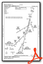
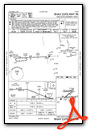
Standard Terminal Arrival (STAR) Charts

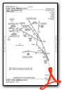
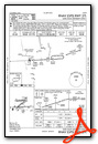
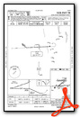
Instrument Approach Procedure (IAP) Charts
Nearby Airports with Instrument Procedures
| ID | Name | Heading / Distance | ||
|---|---|---|---|---|
 |
KCMH | John Glenn Columbus International Airport | 120° | 9.7 |
|
KTZR | Bolton Field Airport | 195° | 11.1 |
|
KDLZ | Delaware Municipal/Jim Moore Field Airport | 351° | 12.1 |
|
KMRT | Union County Airport | 304° | 15.5 |
|
KLCK | Rickenbacker International Airport | 157° | 17.3 |
|
KUYF | Madison County Airport | 243° | 20.0 |
|
KLHQ | Fairfield County Airport | 135° | 27.3 |
|
KVTA | Newark-Heath Airport | 096° | 28.4 |
|
4I9 | Morrow County Airport | 020° | 28.6 |
|
4I3 | Knox County Airport | 059° | 29.3 |
|
I74 | Grimes Field Airport | 275° | 31.5 |
|
KMNN | Marion Municipal Airport | 000° | 32.2 |
Fuel Providers


We proudly offer fuel from:

US Dollar per US Gallon
Price Provided by FBO
Airport Images
Do you have a recent image of this airport? Upload it here!


