Login
Register


OVE
Oroville Municipal Airport
Official FAA Data Effective 2024-03-21 0901Z
Chart Supplement

VFR Chart of KOVE
Sectional Charts at SkyVector.com
IFR Chart of KOVE
Enroute Charts at SkyVector.com
Location Information for KOVE
Coordinates: N39°29.27' / W121°37.32'Located 03 miles SW of Oroville, California on 877 acres of land. View all Airports in California.
Surveyed Elevation is 194 feet MSL.
Operations Data
|
|
Airport Communications
| ASOS: | 121.425 Tel. 530-533-5792 |
|---|---|
| NORCAL APPROACH: | 125.4 259.1 |
| NORCAL DEPARTURE: | 125.4 259.1 |
| CTAF: | 122.800 |
| UNICOM: | 122.800 |
| AWOS-3 at CIC (21.4 NW): | 119.675 530-879-3850 |
| ATIS at CIC (21.5 NW): | 119.675 |
| ATIS at BAB (22.8 S): | 124.55 |
Nearby Navigation Aids
|
| ||||||||||||||||||||||||||||||||||||


Runway 02/20
| Dimensions: | 6020 x 100 feet / 1835 x 30 meters | |
|---|---|---|
| Surface: | Asphalt in Good Condition | |
| Weight Limits: | S-47, D-90 | |
| Edge Lighting: | High Intensity | |
| Runway 02 | Runway 20 | |
| Coordinates: | N39°28.73' / W121°37.91' | N39°29.56' / W121°37.21' |
| Elevation: | 181.5 | 184.6 |
| Traffic Pattern: | Left | Left |
| Runway Heading: | 33° True | 213° True |
| Markings: | Non-Precision Instrument in good condition. | Non-Precision Instrument in good condition. |
| Glide Slope Indicator | P2L (3.00° Glide Path Angle) | P2L (3.00° Glide Path Angle) DOES NOT PRVD OBSTN CLNC BYD 3 NM. |
| REIL: | Yes | Yes |
Runway 13/31
| Dimensions: | 3540 x 100 feet / 1079 x 30 meters | |
|---|---|---|
| Surface: | Asphalt in Good Condition | |
| Weight Limits: | S-19, D-31 | |
| Edge Lighting: | High Intensity | |
| Runway 13 | Runway 31 | |
| Coordinates: | N39°29.71' / W121°37.13' | N39°29.24' / W121°36.69' |
| Elevation: | 192.8 | 176.9 |
| Traffic Pattern: | Left | Left |
| Runway Heading: | 144° True | 324° True |
| Markings: | Basic in good condition. | Basic in good condition. |
| Glide Slope Indicator | P2L (3.00° Glide Path Angle) | P2L (3.00° Glide Path Angle) |
| Obstacles: | 20 ft Trees 600 ft from runway, 200 ft left of center | |
Services Available
| Fuel: | 100LL (blue), Jet-A |
|---|---|
| Transient Storage: | Tiedowns |
| Airframe Repair: | MAJOR |
| Engine Repair: | MINOR |
| Bottled Oxygen: | NONE |
| Bulk Oxygen: | NONE |
| Other Services: | PILOT INSTRUCTION |
Ownership Information
| Ownership: | Publicly owned | |
|---|---|---|
| Owner: | CITY OF OROVILLE | |
| 1735 MONTGOMERY ST | ||
| OROVILLE, CA 95965 | ||
| 530-538-2405 | ||
| Manager: | CODY NISSEN | |
| 1735 MONTGOMERY ST. | ||
| OROVILLE, CA 95965 | ||
| 530-538-2490 | ||
Operational Statistics
| Single Engine Aircraft Based on Field: | 41 | Statistics collected for 12 month period ending 2022-12-31 | |
|---|---|---|---|
| Multi-Engine Aircraft Based on Field: | none | Annual Commercial Operations: | none |
| Jet Aircraft Based on Field: | none | Annual Commuter Operations: | none |
| Helicopters Based on Field: | 1 | Annual Air Taxi Operations: | 1500 |
| Military Aircraft Based on Field: | none | Annual Military Operations: | none |
| Gliders Based on Field: | 1 | Annual GA Local Operations: | 14500 |
| Ultralights Based on Field: | 2 | Annual GA Itinerant Operations: | 20000 |
Other Remarks
- TWY FROM RY 02/20 TO GOLF COURSE/RESTAURANT TIEDOWNS 20 FT WIDE WITH NO SHOULDERS.
- FIREFIGHTING ACFT INVOF ARPT MAY-OCT.
- FOR ARPT INFO MON-FRI CTC (530) 538-2420.
- FOR CD CTC NORCAL APCH AT 916-361-6874.
- ACTVT REIL RWY 02 & 20; PAPI RWY 02, 13, 20 & 31; HIRL RWY 02/20 & RWY 13/31 - CTAF.
Weather Minimums
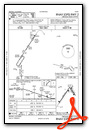
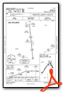
Instrument Approach Procedure (IAP) Charts
Nearby Airports with Instrument Procedures
| ID | Name | Heading / Distance | ||
|---|---|---|---|---|
 |
KCIC | Chico Regional Airport | 329° | 21.4 |
|
KBAB | Beale AFB Airport | 157° | 22.8 |
|
KMYV | Yuba County Airport | 174° | 23.5 |
|
O08 | Colusa County Airport | 223° | 25.3 |
|
KWLW | Willows/Glenn County Airport | 273° | 27.7 |
|
O37 | Haigh Field Airport | 299° | 28.0 |
|
KGOO | Nevada County Airport | 118° | 32.9 |
|
KLHM | Lincoln Regional/Karl Harder Field Airport | 159° | 36.9 |
|
KAUN | Auburn Municipal Airport | 141° | 40.7 |
|
KSMF | Sacramento International Airport | 178° | 47.5 |
|
KRBL | Red Bluff Municipal Airport | 323° | 49.3 |
|
O41 | Watts-Woodland Airport | 193° | 50.2 |
Airport Images

By: gyrosteve

By: CJBScholten


Comments
13/31
.
13/31 Open. Taxiways
13/31 Open. Taxiways different at RWY intersection.