Login
Register


OWD
Norwood Memorial Airport
Official FAA Data Effective 2024-03-21 0901Z
Chart Supplement

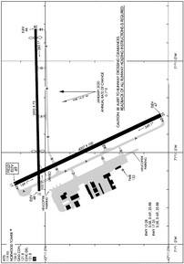
KOWD Airport Diagram
VFR Chart of KOWD
Sectional Charts at SkyVector.com
IFR Chart of KOWD
Enroute Charts at SkyVector.com
Location Information for KOWD
Coordinates: N42°11.43' / W71°10.38'Located 02 miles E of Norwood, Massachusetts on 688 acres of land. View all Airports in Massachusetts.
Surveyed Elevation is 49 feet MSL.
Operations Data
|
|
Airport Communications
| ATIS: | 119.95 (781-769-3825) |
|---|---|
| ASOS: | 119.95 Tel. 781-762-4314 |
| NORWOOD TOWER: | 126.0 |
| NORWOOD GROUND: | 121.8 |
| BOSTON APPROACH: | 124.1 263.1 |
| BOSTON DEPARTURE: | 124.1 343.6 |
| CLEARANCE DELIVERY: | 121.8 |
| CTAF: | 126.000 |
| EMERG: | 121.5 |
| WOONS STAR: | 120.6 263.1 |
| D-ATIS at BOS (12.7 NE): | 135.0 ;ARR |
| ASOS at BOS (13.2 NE): | 135.0 617-567-5762 |
| ATIS at BED (17.5 N): | 124.6 |
Nearby Navigation Aids
|
| ||||||||||||||||||||||||||||||||||||||||||||||||||||||||||||


Runway 17/35
| Dimensions: | 4007 x 100 feet / 1221 x 30 meters | |
|---|---|---|
| Surface: | Asphalt / Grooved in Good Condition | |
| Weight Limits: | S-58, D-69 | |
| Edge Lighting: | Medium Intensity | |
| Runway 17 | Runway 35 | |
| Coordinates: | N42°11.63' / W71°10.67' | N42°11.03' / W71°10.29' |
| Elevation: | 49.2 | 47.1 |
| Traffic Pattern: | Left | Right |
| Runway Heading: | 155° True | 335° True |
| Markings: | Non-Precision Instrument in good condition. | Non-Precision Instrument in good condition. |
| Glide Slope Indicator | P4R (3.00° Glide Path Angle) | P4L (3.00° Glide Path Angle) |
| Approach Lights: | MALSF 1,400 Foot Medium-intensity Approach Lighting System with sequenced flashers. | |
| Obstacles: | 26 ft Trees 850 ft from runway, 125 ft right of center | |
Runway 10/28
| Dimensions: | 3995 x 75 feet / 1218 x 23 meters | |
|---|---|---|
| Surface: | Asphalt in Good Condition | |
| Weight Limits: | S-58, D-69 | |
| Runway 10 | Runway 28 | |
| Coordinates: | N42°11.53' / W71°10.71' | N42°11.54' / W71°9.83' |
| Elevation: | 48.4 | 46.1 |
| Traffic Pattern: | Left | Right & 35 RIGHT TFC FOR TGL ONLY. |
| Runway Heading: | 89° True | 269° True |
| Displaced Threshold: | 987 Feet | 212 Feet |
| Declared Distances: | TORA:3995 TODA:3995 ASDA:3782 LDA:2795 | TORA:3995 TODA:3995 ASDA:3808 LDA:3595 |
| Markings: | Basic in good condition. | Basic in good condition. |
| Glide Slope Indicator | P4R (4.00° Glide Path Angle) | |
| Obstacles: | 40 ft Trees 1200 ft from runway, 125 ft left of center APCH RATIO 50:1 TO DTHR. |
40 ft Trees 1000 ft from runway, 125 ft right of center |
Services Available
| Fuel: | 100LL (blue), Jet-A, Jet A+ |
|---|---|
| Transient Storage: | Hangars,Tiedowns |
| Airframe Repair: | MAJOR |
| Engine Repair: | MAJOR |
| Bottled Oxygen: | LOW |
| Bulk Oxygen: | NONE |
| Other Services: | CHARTER SERVICE,PILOT INSTRUCTION,AIRCRAFT RENTAL,ANNUAL SURVEYING |
Ownership Information
| Ownership: | Publicly owned | |
|---|---|---|
| Owner: | TOWN OF NORWOOD | |
| 566 WASHINGTON ST | ||
| NORWOOD, MA 02062 | ||
| 781-762-1240 | ||
| Manager: | MARK RAYMOND | |
| 111 ACCESS RD | ||
| NORWOOD, MA 02062 | ||
| 781-255-5615 | ||
Operational Statistics
| Single Engine Aircraft Based on Field: | 74 | Statistics collected for 12 month period ending 2020-01-31 | |
|---|---|---|---|
| Multi-Engine Aircraft Based on Field: | 6 | Annual Commercial Operations: | none |
| Jet Aircraft Based on Field: | 6 | Annual Commuter Operations: | none |
| Helicopters Based on Field: | 14 | Annual Air Taxi Operations: | 5057 |
| Military Aircraft Based on Field: | none | Annual Military Operations: | 95 |
| Gliders Based on Field: | none | Annual GA Local Operations: | 24234 |
| Ultralights Based on Field: | none | Annual GA Itinerant Operations: | 29242 |
Other Remarks
- 1199 FT /1349 FT MSL/ AND 1249 FT /1349 FT MSL/ TV TWR 8 NM NNW. 1063.5 FT /1184 FT MSL/ TWR 8.5 NM NNW.
- ALL ACFT EXCEEDING 87 EFF PERCEIVED NOISE LEVEL IN DBS OR 75 DBS, AS MEASURED IN PART 36 PROHIBITED FM USING ARPT.
- 125 FT FLAGPOLE 1 MI NW OF RWY 17 APCH.
- GATE 2 TXL LTD TO ACFT WITH WINGSPANS OF 50 FT OR LESS. GATE 3 TXL LTD TO ACFT WITH WINGSPANS OF 45 FT OR LESS.
- BIRD ACTVTY & WILDLIFE INVOF ARPT.
- SN REMOVAL EQUIP BLDG (ABUTTING SOUTH APRON).
- LDG FEES FOR TSNT FIXED-WING ACFT WITH MORE THAN 5000 LBS MAX TOG, AS WELL AS TSNT HELS REGARDLESS OF WT.
- WHEN ATCT CLSD ACTVT MALSF RWY 35; PAPI RWYS 10, 17 & 35; MIRL 17/35 - CTAF.
Weather Minimums
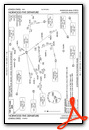
Standard Terminal Arrival (STAR) Charts
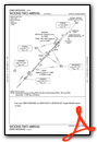
Instrument Approach Procedure (IAP) Charts
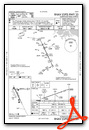
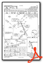
Departure Procedure (DP) Charts
Nearby Airports with Instrument Procedures
| ID | Name | Heading / Distance | ||
|---|---|---|---|---|
 |
1B9 | Mansfield Municipal Airport | 185° | 11.4 |
|
KBOS | General Edward Lawrence Logan International Airport | 035° | 12.7 |
|
1B6 | Hopedale Industrial Park Airport | 251° | 15.9 |
|
KBED | Laurence G Hanscom Field Airport | 342° | 17.5 |
|
KTAN | Taunton Municipal - King Field Airport | 159° | 20.2 |
|
KSFZ | North Central State Airport | 221° | 21.6 |
|
6B6 | Minute Man Air Field Airport | 316° | 22.3 |
|
KGHG | Marshfield Municipal - George Harlow Field Airport | 103° | 23.0 |
|
KPYM | Plymouth Municipal Airport | 130° | 26.1 |
|
KBVY | Beverly Regional Airport | 025° | 26.2 |
|
KPVD | Rhode Island Tf Green International Airport | 202° | 30.3 |
|
KORH | Worcester Regional Airport | 278° | 31.7 |


Comments
2021 Holiday Schedule:
2021 Holiday Schedule: Thanksgiving 0700-1900 ; maintenance closed
Christmas: Closed; Calls ins available fees will apply. 800-370-8680 opt 1 ; maintenance closed
Pages