Login
Register


PBG
Plattsburgh International Airport
Official FAA Data Effective 2024-04-18 0901Z
Chart Supplement

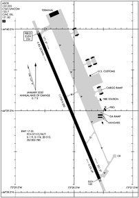
KPBG Airport Diagram
VFR Chart of KPBG
Sectional Charts at SkyVector.com
IFR Chart of KPBG
Enroute Charts at SkyVector.com
Location Information for KPBG
Coordinates: N44°39.06' / W73°28.09'Located 03 miles S of Plattsburgh, New York on 1912 acres of land. View all Airports in New York.
Surveyed Elevation is 234 feet MSL.
Operations Data
|
|
Airport Communications
| ASOS: | 132.225 Tel. 518-324-5539 |
|---|---|
| BURLINGTON APPROACH: | 121.1 278.8 |
| BURLINGTON DEPARTURE: | 121.1 278.8 |
| CLEARANCE DELIVERY: | 121.85 ;CTC APCH CTL |
| UNICOM: | 122.700 |
| CTAF: | 122.700 |
| ATIS at BTV (17.2 SE): | 123.8 |
| ASOS at BTV (17.5 SE): | 123.8 802-657-4490 |
| AWOS-3 at FSO (23.5 NE): | 119.025 802-868-9941 |
- APCH/DEP SVC PRVDD BY BOSTON ARTCC ON FREQS 120.35/342.25 (ST. ALBANS RCAG) WHEN BURLINGTON APCH CTL CLSD.
Nearby Navigation Aids
|
| ||||||||||||||||||||||||||||||||||||||||||||||||||||||||||||


Runway 17/35
| Dimensions: | 11759 x 200 feet / 3584 x 61 meters | |
|---|---|---|
| Surface: | Asphalt / Grooved in Good Condition | |
| Weight Limits: | S-119, D-174, ST-510, DT-780
PCR VALUE: 548/F/C/W/T
| |
| Edge Lighting: | High Intensity | |
| Runway 17 | Runway 35 | |
| Coordinates: | N44°39.95' / W73°28.61' | N44°38.16' / W73°27.57' |
| Elevation: | 234.2 | 159.8 |
| Traffic Pattern: | Right | Left |
| Runway Heading: | 157° True | 337° True |
| Declared Distances: | TORA:11759 TODA:11759 ASDA:11759 LDA:11759 | TORA:11759 TODA:11759 ASDA:11759 LDA:11759 |
| Markings: | Precision Instrument in good condition. | Precision Instrument in good condition. |
| Glide Slope Indicator | P4L (3.00° Glide Path Angle) | P4L (3.00° Glide Path Angle) |
| Approach Lights: | MALSR 1,400 Foot Medium-intensity Approach Lighting System with runway alignment indicator lights. | |
| REIL: | Yes | |
| Obstacles: | 68 ft Tree 1600 ft from runway, 630 ft right of center | 72 ft Tree 1720 ft from runway, 220 ft left of center |
Services Available
| Fuel: | 100LL (blue), Jet-A |
|---|---|
| Transient Storage: | Hangars,Tiedowns |
| Airframe Repair: | MINOR |
| Engine Repair: | NOT AVAILABLE |
| Bottled Oxygen: | HIGH |
| Bulk Oxygen: | NOT AVAILABLE |
| Other Services: | AVIONICS |
Ownership Information
| Ownership: | Publicly owned | |
|---|---|---|
| Owner: | CLINTON COUNTY | |
| 137 MARGARET ST | ||
| PLATTSBURGH, NY 12901 | ||
| 518-565- 4600 | ||
| Manager: | CHRISTOPHER D. KREIG | |
| 42 AIRPORT LANE SUITE 201 | ||
| PLATTSBURGH, NY 12903 | ||
| 518-565-4794 | ||
Operational Statistics
| Single Engine Aircraft Based on Field: | 30 | Statistics collected for 12 month period ending 2023-05-31 | |
|---|---|---|---|
| Multi-Engine Aircraft Based on Field: | 5 | Annual Commercial Operations: | 823 |
| Jet Aircraft Based on Field: | none | Annual Commuter Operations: | none |
| Helicopters Based on Field: | 2 | Annual Air Taxi Operations: | 3031 |
| Military Aircraft Based on Field: | none | Annual Military Operations: | 300 |
| Gliders Based on Field: | none | Annual GA Local Operations: | 4200 |
| Ultralights Based on Field: | none | Annual GA Itinerant Operations: | 4800 |
Other Remarks
- DURG PDS OF SNOW REMOVAL OPS NOV 1 - MAY 1 ACFT CTC 122.7 OR 518-335-3279 15 MIN PRIOR TO LDG.
- ACFT ARRIVING OR DEPARTING PBG MUST ANNOUNCE INTENTIONS ON CTAF.
- PPR AND ARFF INDEX E CALL 518-335-3735.
- FOR CD CTC BURLINGTON APCH AT 802-657-4413, WHEN APCH CLSD CTC BOSTON ARTCC AT 603-879-6859.
- US CUST AVBL MON-FRI, 0800-1600 HOURS. PPR 24 HOURS FOR AFT HOURS; CTC CBP SUPVR @ 518-324-5617.
- SKYDIVING OPNS SOUTHEAST OF ARPT, INVOF FBO.
- EXP DOWNDRAFTS & TURB DURG PDS OF STRONG CROSSWINDS.
- ACTVT MALSR RWY 35; REIL RWY 17; HIRL RWY 17/35; TWY LGTS - CTAF.
Weather Minimums
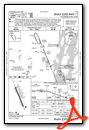
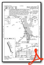
Instrument Approach Procedure (IAP) Charts
Nearby Airports with Instrument Procedures
| ID | Name | Heading / Distance | ||
|---|---|---|---|---|
 |
KBTV | Patrick Leahy Burlington International Airport | 128° | 17.3 |
|
KFSO | Franklin County State Airport | 042° | 23.5 |
|
KLKP | Lake Placid Airport | 222° | 31.4 |
|
KSLK | Adirondack Regional Airport | 243° | 35.5 |
|
KMVL | Morrisville-Stowe State Airport | 100° | 37.3 |
|
KMAL | Malone-Dufort Airport | 288° | 38.8 |
|
CYJN | St Jean Airport | 011° | 39.4 |
|
4B6 | Ticonderoga Municipal Airport | 177° | 46.5 |
|
KMPV | Edward F Knapp State Airport | 124° | 47.3 |
|
KEFK | Northeast Kingdom International Airport | 074° | 54.9 |
|
KMSS | Massena International-Richards Field Airport | 286° | 61.3 |
|
KCDA | Caledonia County Airport | 094° | 62.3 |
Airport Images

By: jfreesemd


