Login
Register


PGA
Page Municipal Airport
Official FAA Data Effective 2024-04-18 0901Z
Chart Supplement

VFR Chart of KPGA
Sectional Charts at SkyVector.com
IFR Chart of KPGA
Enroute Charts at SkyVector.com
Location Information for KPGA
Coordinates: N36°55.56' / W111°26.90'Located 01 miles E of Page, Arizona on 555 acres of land. View all Airports in Arizona.
Surveyed Elevation is 4316 feet MSL.
Operations Data
|
|
Airport Communications
| ASOS: | 120.625 Tel. 928-645-1228 |
|---|---|
| CTAF: | 122.800 |
| UNICOM: | 122.800 |
| AWOS-3 at KNB (52.2 W): | 133.175 435-644-2267 |
| AWOS-3 at U96 (52.4 NE): | 134.375 435-684-2419 |
| ASOS at BCE (57.3 NW): | 135.475 435-834-5270 |
- APCH/DEP CTL SVC PRVDD BY DENVER ARTCC (ZDV) ON FREQ 127.55/256.875 (TUBA CITY RCAG).
Nearby Navigation Aids
|
| ||||||||||||||||||||||||||||||||||||


Runway 15/33
| Dimensions: | 5950 x 150 feet / 1814 x 46 meters | |
|---|---|---|
| Surface: | Asphalt in Good Condition | |
| Weight Limits: | 15 /F/C/W/T, S-65, D-90, ST-190 | |
| Edge Lighting: | Medium Intensity | |
| Runway 15 | Runway 33 | |
| Coordinates: | N36°55.97' / W111°26.97' | N36°55.00' / W111°26.76' |
| Elevation: | 4245.3 | 4316.6 |
| Traffic Pattern: | Left | Right |
| Runway Heading: | 170° True | 350° True |
| Declared Distances: | TORA:5950 TODA:5950 ASDA:5950 LDA:5950 | TORA:5950 TODA:5950 ASDA:5950 LDA:5950 |
| Markings: | Non-Precision Instrument in good condition. | Non-Precision Instrument in good condition. |
| Glide Slope Indicator | V4L (3.00° Glide Path Angle) | V4L (3.00° Glide Path Angle) |
| REIL: | Yes | Yes |
Runway 07/25
RWY 07/25 USE ONLY DURG HIGH WINDS FM E OR W. | ||
| Dimensions: | 2201 x 75 feet / 671 x 23 meters | |
|---|---|---|
| Surface: | Asphalt in Good Condition | |
| Weight Limits: | 2 /F/D/Y/T, D-12 | |
| Runway 07 | Runway 25 | |
| Coordinates: | N36°55.75' / W111°27.21' | N36°55.80' / W111°26.76' |
| Elevation: | 4243.1 | 4250.7 |
| Traffic Pattern: | Left | Right |
| Runway Heading: | 82° True | 262° True |
| Displaced Threshold: | 588 Feet | |
| Declared Distances: | TORA:2201 TODA:2201 ASDA:2201 LDA:1613 | TORA:2201 TODA:2201 ASDA:2201 LDA:2201 |
| Markings: | Basic in fair condition. | Numbers Only in fair condition. |
Services Available
| Fuel: | 100LL (blue), Jet-A |
|---|---|
| Transient Storage: | Tiedowns |
| Airframe Repair: | MAJOR |
| Engine Repair: | MAJOR |
| Bottled Oxygen: | HIGH/LOW |
| Bulk Oxygen: | HIGH |
| Other Services: | AIR FREIGHT SERVICES,CHARTER SERVICE,PILOT INSTRUCTION,AIRCRAFT RENTAL |
Ownership Information
| Ownership: | Publicly owned | |
|---|---|---|
| Owner: | CITY OF PAGE | |
| BOX 1180 | ||
| PAGE, AZ 86040 | ||
| 928-645-8861 | ||
| Manager: | KYLE CHRISTIANSEN | EMAIL: KCHRISTIANSEN@PAGEAZ.GOV |
| PO BOX 1180, 697 VISTA AVENUE | ||
| PAGE, AZ 86040 | ||
| 928-645-4240 | ||
Operational Statistics
| Single Engine Aircraft Based on Field: | 54 | Statistics collected for 12 month period ending 2022-12-31 | |
|---|---|---|---|
| Multi-Engine Aircraft Based on Field: | 11 | Annual Commercial Operations: | 1134 |
| Jet Aircraft Based on Field: | 2 | Annual Commuter Operations: | none |
| Helicopters Based on Field: | 3 | Annual Air Taxi Operations: | 6886 |
| Military Aircraft Based on Field: | none | Annual Military Operations: | 72 |
| Gliders Based on Field: | none | Annual GA Local Operations: | 1000 |
| Ultralights Based on Field: | none | Annual GA Itinerant Operations: | 7990 |
Other Remarks
- FOR CD CTC DENVER ARTCC ON FREQ. IF UNA, CTC FSS ON FREQ VIA RCO. IF UNA, CTC DENVER ARTCC AT 303-651-4257.
- OVERNIGHT PARKING FEE
- 0LL AFT HR - 928-645-5356.
- ACTVT REIL RWY 15 & 33; MIRL 15/33 - CTAF. VASI RWY 15 & 33 ON CONSLY.
- UNICOM ADZY AVBL 122.8 SR - SS.
Weather Minimums
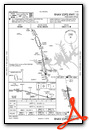
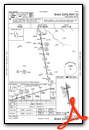
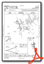
Instrument Approach Procedure (IAP) Charts
Nearby Airports with Instrument Procedures
| ID | Name | Heading / Distance | ||
|---|---|---|---|---|
 |
1L7 | Escalante Municipal Airport | 353° | 49.4 |
|
KKNB | Kanab Municipal Airport | 275° | 52.3 |
|
KBCE | Bryce Canyon Airport | 324° | 57.5 |
|
KGCN | Grand Canyon Ntl Park Airport | 210° | 67.4 |
|
U55 | Panguitch Municipal Airport | 320° | 71.2 |
|
KAZC | Colorado City Municipal Airport | 272° | 75.3 |
|
40G | Valle Airport | 204° | 83.6 |
|
KCDC | Cedar City Regional Airport | 300° | 91.6 |
|
U52 | Beaver Municipal Airport | 323° | 97.7 |
|
KSGU | St George Regional Airport | 274° | 99.3 |
|
KBDG | Blanding Municipal Airport | 066° | 102.0 |
|
KCMR | H A Clark Memorial Field Airport | 200° | 103.6 |


Comments
Excellent runway in beautiful
Excellent runway in beautiful setting. Large ramp area with probably the most Cessna 207's you'll every see in one spot. 33 is the prefered runway. I've purchased fuel from Titan and Classic and had good service from both FBO's. Classic will provide a courtesy car with fuel purchase. I don't know about Titan. However, restaraunts are but a short walk away and I usually stretch my legs. The airport can get busy, so be on your toes. It's right traffic on 33 and left traffic on 15.
Pages