Login
Register


PGD
Punta Gorda Airport
Official FAA Data Effective 2024-04-18 0901Z
Chart Supplement

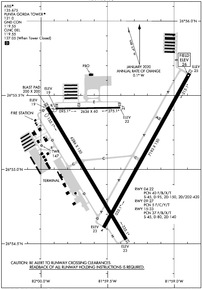
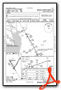
KPGD Airport Diagram
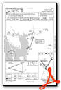
VFR Chart of KPGD
Sectional Charts at SkyVector.com
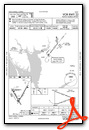
IFR Chart of KPGD
Enroute Charts at SkyVector.com
Location Information for KPGD
Coordinates: N26°55.12' / W81°59.45'Located 03 miles SE of Punta Gorda, Florida on 1934 acres of land. View all Airports in Florida.
Surveyed Elevation is 25 feet MSL.
Operations Data
|
|
Airport Communications
| ATIS: | 135.675 |
|---|---|
| ASOS: | 135.675 Tel. 941-639-0076 |
| PUNTA GORDA TOWER: | 121.0 |
| PUNTA GORDA GROUND: | 119.55 |
| FORT MYERS APPROACH: | 127.05 306.2 |
| FORT MYERS DEPARTURE: | 127.05 306.2 |
| IC: | 306.2 |
| CLEARANCE DELIVERY: | 119.55 127.05 ;WHEN TWR CLSD |
| UNICOM: | 122.975 |
| PIKKR STAR: | 127.05 ;5000 FT & BLO 134.425 ;6000 FT & ABV 306.2 |
| CTAF: | 121.000 |
| LUBBR STAR: | 119.65 353.575 |
| AWOS-3PT at 54A (14.1 W): | 120.00 941-725-0701 |
| ATIS at FMY (21.1 S): | 123.725 |
| ASOS at FMY (21.1 S): | 123.725 239-936-2318 |
- APCH/DEP SVC PRVDD BY MIAMI ARTCC ON FREQS 134.75/322.5 (FORT MYERS RCAG) WHEN FORT MYERS APCH CTL CLSD.
- WHEN ATCT CLSD CLNC DEL 127.05 MONITORED BY FORT MYERS APCH CTL.
Nearby Navigation Aids
|
| ||||||||||||||||||||||||||||||||||||||||||||||||


Runway 04/22
| Dimensions: | 7193 x 150 feet / 2192 x 46 meters | |
|---|---|---|
| Surface: | Asphalt / Grooved in Fair Condition | |
| Weight Limits: | 40 /F/B/X/T, S-45, D-95, ST-150, DT-420 | |
| Edge Lighting: | High Intensity | |
| Runway 04 | Runway 22 | |
| Coordinates: | N26°54.61' / W81°59.53' | N26°55.65' / W81°58.88' |
| Elevation: | 23.2 | 25.4 |
| Traffic Pattern: | Left | Left |
| Runway Heading: | 29° True | 209° True |
| Markings: | Precision Instrument in good condition. | Non-Precision Instrument in good condition. |
| Glide Slope Indicator | P4L (3.00° Glide Path Angle) | P4L (3.00° Glide Path Angle) |
| REIL: | Yes | Yes |
| Obstacles: | 31 ft Trees 1770 ft from runway, 390 ft right of center | |
Runway 15/33
| Dimensions: | 6286 x 150 feet / 1916 x 46 meters | |
|---|---|---|
| Surface: | Asphalt / Grooved in Excellent Condition | |
| Weight Limits: | 37 /F/B/X/T, S-45, D-80, ST-140 | |
| Edge Lighting: | Medium Intensity | |
| Runway 15 | Runway 33 | |
| Coordinates: | N26°55.42' / W81°59.95' | N26°54.53' / W81°59.36' |
| Elevation: | 18.5 | 23.0 |
| Traffic Pattern: | Left | Left |
| Runway Heading: | 149° True | 329° True |
| Displaced Threshold: | 271 Feet | |
| Declared Distances: | TORA:6286 TODA:6286 ASDA:6286 LDA:6015 | TORA:6166 TODA:6166 ASDA:6015 LDA:6015 |
| Markings: | Non-Precision Instrument in good condition. | Non-Precision Instrument in good condition. |
| Glide Slope Indicator | P4L (3.00° Glide Path Angle) | P4L (3.00° Glide Path Angle) |
| REIL: | Yes | Yes |
| Obstacles: | 15 ft Road 460 ft from runway, 500 ft right of center RWY 15 APCH SLP 48:1 TO DTHR. |
54 ft Trees 2375 ft from runway, 60 ft right of center |
Runway 09/27
RSTRD TO ACFT LESS THAN 6000 LBS. NOT AVBL FOR SKED ACR OPS WITH MORE THAN 9 PAX SEATS OR UNSKED ACR AT LEAST 31 PAX SEATS. | ||
| Dimensions: | 2636 x 60 feet / 803 x 18 meters | |
|---|---|---|
| Surface: | Asphalt in Poor Condition | |
| Weight Limits: | 5 /F/C/Y/T | |
| Runway 09 | Runway 27 | |
| Coordinates: | N26°55.41' / W81°59.89' | N26°55.42' / W81°59.40' |
| Elevation: | 19.1 | 22.1 |
| Traffic Pattern: | Left | Left |
| Runway Heading: | 89° True | 269° True |
| Declared Distances: | TORA:2635 TODA:2635 ASDA:2635 LDA:2635 | TORA:2635 TODA:2635 ASDA:2635 LDA:2635 |
| Markings: | Basic in poor condition. | Basic in poor condition. |
| Obstacles: | 40 ft Trees 2210 ft from runway, 250 ft left of center | |
Services Available
| Fuel: | 100LL (blue), Jet-A, Jet A+ |
|---|---|
| Transient Storage: | Hangars,Tiedowns |
| Airframe Repair: | MAJOR |
| Engine Repair: | MAJOR |
| Bottled Oxygen: | NONE |
| Bulk Oxygen: | HIGH/LOW |
| Other Services: | CHARTER SERVICE,PILOT INSTRUCTION,AIRCRAFT RENTAL |
Ownership Information
| Ownership: | Publicly owned | |
|---|---|---|
| Owner: | CHARLOTTE COUNTY ARPT AUTH | |
| 28000 A-1 AIRPORT RD | ||
| PUNTA GORDA, FL 33982 | ||
| 941-639-1101 | ||
| Manager: | JAMES W PARISH | |
| 28000 A-1 AIRPORT RD | ||
| PUNTA GORDA, FL 33982 | ||
| 941-639-1101 | 941-639-1101 EXT123. | |
Operational Statistics
| Single Engine Aircraft Based on Field: | 331 | Statistics collected for 12 month period ending 2023-12-31 | |
|---|---|---|---|
| Multi-Engine Aircraft Based on Field: | 36 | Annual Commercial Operations: | 12012 |
| Jet Aircraft Based on Field: | 21 | Annual Commuter Operations: | none |
| Helicopters Based on Field: | 11 | Annual Air Taxi Operations: | 1454 |
| Military Aircraft Based on Field: | none | Annual Military Operations: | 1993 |
| Gliders Based on Field: | 1 | Annual GA Local Operations: | 38467 |
| Ultralights Based on Field: | 4 | Annual GA Itinerant Operations: | 49326 |
Other Remarks
- FOR CD IF UNA TO CTC ON FSS FREQ, CTC FT MYERS APCH AT 239-416-1026, WHEN APCH CLSD CTC MIAMI ARTCC AT 305-716-1731.
- 0LL FUEL 24 HR CREDIT CARD SVC AVBL.
- ACTVT REIL RWY 04, 15, 22 & 33; PAPI RWY 04, 15, 22 & 33 - CTAF. HIRL RWY 04/22; MIRL RWY 15/33 PRESET ON LOW INTST; TO INCR INTST - CTAF.
Weather Minimums


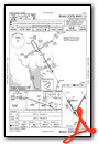
Standard Terminal Arrival (STAR) Charts
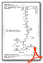
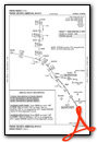
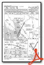
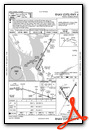
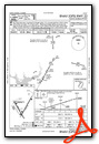
Instrument Approach Procedure (IAP) Charts
Nearby Airports with Instrument Procedures
| ID | Name | Heading / Distance | ||
|---|---|---|---|---|
 |
FA54 | Coral Creek Airport | 254° | 14.6 |
|
X06 | Arcadia Municipal Airport | 026° | 18.5 |
|
KFMY | Page Field Airport | 160° | 21.0 |
|
KVNC | Venice Municipal Airport | 290° | 25.7 |
|
KRSW | Southwest Florida International Airport | 150° | 26.2 |
|
X14 | La Belle Municipal Airport | 109° | 32.0 |
|
KCHN | Wauchula Municipal Airport | 009° | 36.2 |
|
KSRQ | Sarasota/Bradenton International Airport | 313° | 41.5 |
|
KIMM | Immokalee Regional Airport | 132° | 43.0 |
|
KAVO | Avon Park Exec Airport | 031° | 47.2 |
|
KSEF | Sebring Regional Airport | 047° | 47.3 |
|
KAPF | Naples Municipal Airport | 165° | 47.3 |
Airport Images
Do you have a recent image of this airport? Upload it here!


Comments
communications listed above are wrong - Use A/FD
Dan