Login
Register


PGR
Kirk Field Airport
Official FAA Data Effective 2024-04-18 0901Z
Chart Supplement

VFR Chart of KPGR
Sectional Charts at SkyVector.com
IFR Chart of KPGR
Enroute Charts at SkyVector.com
Location Information for KPGR
Coordinates: N36°3.83' / W90°30.55'Located 01 miles NW of Paragould, Arkansas on 220 acres of land. View all Airports in Arkansas.
Surveyed Elevation is 290 feet MSL.
Operations Data
|
|
Airport Communications
| CTAF: | 122.800 |
|---|---|
| UNICOM: | 122.800 |
| ASOS at JBR (15.2 SW): | 118.525 870-932-4010 |
| AWOS-3PT at ARG (20.5 W): | 126.525 870-886-2537 |
| AWOS-3T at 4M9 (21.8 N): | 118.325 870-857-9702 |
- APCH/DEP SVC PRVDD BY MEMPHIS ARTCC ON FREQS 120.075/289.4 (WALNUT RIDGE RCAG).
Nearby Navigation Aids
|
| ||||||||||||||||||||||||||||||||||||||||||||||||||||||||||||


Runway 04/22
| Dimensions: | 4500 x 75 feet / 1372 x 23 meters | |
|---|---|---|
| Surface: | Asphalt in Good Condition | |
| Weight Limits: | S-12 | |
| Edge Lighting: | Medium Intensity | |
| Runway 04 | Runway 22 | |
| Coordinates: | N36°3.52' / W90°30.80' | N36°4.03' / W90°30.14' |
| Elevation: | 289.6 | 285.0 |
| Traffic Pattern: | Left | Left |
| Runway Heading: | 46° True | 226° True |
| Displaced Threshold: | 489 Feet | 148 Feet |
| Markings: | Non-Precision Instrument in fair condition. | Non-Precision Instrument in fair condition. |
| Glide Slope Indicator | P2L (3.00° Glide Path Angle) | P2L (4.00° Glide Path Angle) |
| REIL: | Yes | Yes |
| Obstacles: | 28 ft Road 180 ft from runway APCH RATIO 23:1 TO DSPLCD THLD. ROAD 180 FT & EXTENDS INTO RY PROTECTION ZONE. |
13 ft Road 460 ft from runway, 200 ft left of center APCH SLOPE 46:1 TO DSPLD THLD. OPEN DITCH 55 FT WIDE; 10 FT DEEP 138 FT FM THLD CROSSING. |
Runway 08/26
SOFT WHEN WET. | ||
| Dimensions: | 2792 x 100 feet / 851 x 30 meters | |
|---|---|---|
| Surface: | Turf in Fair Condition | |
| Runway 08 | Runway 26 | |
| Coordinates: | N36°3.91' / W90°30.97' | N36°3.92' / W90°30.41' |
| Elevation: | 283.0 | 279.0 |
| Traffic Pattern: | Left | Left |
| Runway Heading: | 89° True | 269° True |
| Markings: | Non-Standard in good condition. | Non-Standard in good condition. |
| Obstacles: | 40 ft Power Line 1300 ft from runway, 50 ft right of center | 40 ft Trees 1750 ft from runway |
Services Available
| Fuel: | 100LL (blue), Jet-A |
|---|---|
| Transient Storage: | Tiedowns |
| Airframe Repair: | NOT AVAILABLE |
| Engine Repair: | NOT AVAILABLE |
| Bottled Oxygen: | NONE |
| Bulk Oxygen: | NONE |
| Other Services: | AIR AMBULANCE SERVICES,PILOT INSTRUCTION |
Ownership Information
| Ownership: | Publicly owned | |
|---|---|---|
| Owner: | CITY OF PARAGOULD | |
| 301 WEST COURT | ||
| PARAGOULD, AR 72450 | ||
| 870-239-7510 | ||
| Manager: | ROGER SLAYTON | |
| 305 AIRPORT ROAD | ||
| PARAGOULD, AR 72450 | ||
| 870-239-7505 | ||
Operational Statistics
| Single Engine Aircraft Based on Field: | 47 | Statistics collected for 12 month period ending 2021-02-28 | |
|---|---|---|---|
| Multi-Engine Aircraft Based on Field: | 3 | Annual Commercial Operations: | none |
| Jet Aircraft Based on Field: | none | Annual Commuter Operations: | none |
| Helicopters Based on Field: | none | Annual Air Taxi Operations: | 500 |
| Military Aircraft Based on Field: | none | Annual Military Operations: | none |
| Gliders Based on Field: | none | Annual GA Local Operations: | 5500 |
| Ultralights Based on Field: | none | Annual GA Itinerant Operations: | 7000 |
Other Remarks
- THIS AIRPORT HAS BEEN SURVEYED BY THE NATIONAL GEODETIC SURVEY.
- UNLGTD TOWER 250 FT AGL .17 MILES ESE AER 04.
- WILDLIFE ON & INVOF OF RY AND TWY.
- FOR CD CTC MEMPHIS ARTCC AT 901-368-8453/8449.
- 0LL 24 HR SELF SVC FUEL AVBL WITH CREDIT CARD (100LL & JET A)
- ACTVT MIRL RY 04/22, REIL & PAPI RYS 04 & 22 - CTAF.
Weather Minimums

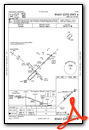
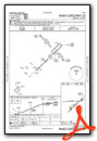
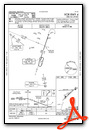
Instrument Approach Procedure (IAP) Charts
Nearby Airports with Instrument Procedures
| ID | Name | Heading / Distance | ||
|---|---|---|---|---|
 |
KJBR | Jonesboro Municipal Airport | 205° | 15.4 |
|
KMXA | Manila Municipal Airport | 120° | 20.0 |
|
KARG | Walnut Ridge Regional Airport | 280° | 20.6 |
|
4M9 | Corning Municipal Airport | 341° | 21.5 |
|
M70 | Pocahontas Municipal Airport | 296° | 24.3 |
|
KTKX | Kennett Memorial Airport | 066° | 24.9 |
|
KBYH | Arkansas International Airport | 102° | 28.2 |
|
M12 | Steele Municipal Airport | 086° | 31.7 |
|
7M4 | Osceola Municipal Airport | 132° | 33.0 |
|
KHKA | Blytheville Municipal Airport | 102° | 33.8 |
|
M85 | Gideon Memorial Airport | 052° | 37.2 |
|
KMAW | Malden Regional Airport | 037° | 40.7 |
Airport Images
Do you have a recent image of this airport? Upload it here!


