Login
Register


PNC
Ponca City Regional Airport
Official FAA Data Effective 2024-04-18 0901Z
Chart Supplement

VFR Chart of KPNC
Sectional Charts at SkyVector.com
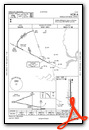
IFR Chart of KPNC
Enroute Charts at SkyVector.com
Location Information for KPNC
Coordinates: N36°43.92' / W97°5.99'Located 02 miles NW of Ponca City, Oklahoma on 500 acres of land. View all Airports in Oklahoma.
Surveyed Elevation is 1008 feet MSL.
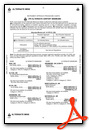
Operations Data
|
|
Airport Communications
| ASOS: | 134.075 Tel. 580-765-0049 |
|---|---|
| UNICOM: | 123.000 |
| CTAF: | 123.000 |
| AWOS-3PT at BKN (12.0 W): | 120.575 580-363-0688 |
| ASOS at WLD (26.4 N): | 118.025 620-221-9121 |
| ASOS at SWO (34.2 S): | 135.725 405-743-8150 |
- APCH/DEP CTL SVC PRVDD BY KANSAS CITY ARTCC (ZKC) ON FREQS 127.8/319.1 (PONCA CITY RCAG).
Nearby Navigation Aids
|
| ||||||||||||||||||||||||||||||||||||||||||||||||||||||||||||


Runway 17/35
| Dimensions: | 7201 x 100 feet / 2195 x 30 meters NORTH 2400 FT NSTD PLASTIC GROOVING ENTIRE WIDTH; 25 FT EACH EDGE REMAINING 4801 FT. | |
|---|---|---|
| Surface: | Concrete / Grooved in Good Condition | |
| Weight Limits: | S-51, D-65, ST-122 | |
| Edge Lighting: | High Intensity | |
| Runway 17 | Runway 35 | |
| Coordinates: | N36°44.51' / W97°5.99' | N36°43.32' / W97°5.98' |
| Elevation: | 993.7 | 1008.6 |
| Traffic Pattern: | Right | Left |
| Runway Heading: | 180° True | 360° True |
| Markings: | Precision Instrument in good condition. | Precision Instrument in fair condition. |
| Glide Slope Indicator | P4L (3.00° Glide Path Angle) | P4L (3.00° Glide Path Angle) PAPI UNUSBL BYD 8 DEGS RIGHT OF CNTRLN. |
| Approach Lights: | MALSR 1,400 Foot Medium-intensity Approach Lighting System with runway alignment indicator lights. | ODALS Omnidirectional Approach Lighting System |
| Obstacles: | 28 ft Building 710 ft from runway, 555 ft left of center | |
Services Available
| Fuel: | 100LL (blue), Jet-A |
|---|---|
| Transient Storage: | Hangars,Tiedowns |
| Airframe Repair: | MAJOR |
| Engine Repair: | MAJOR |
| Bottled Oxygen: | LOW |
| Bulk Oxygen: | NONE |
| Other Services: | AIR AMBULANCE SERVICES,CHARTER SERVICE,PILOT INSTRUCTION,AIRCRAFT RENTAL,AIRCRAFT SALES |
Ownership Information
| Ownership: | Publicly owned | |
|---|---|---|
| Owner: | CITY OF PONCA CITY | |
| BOX 1450 | ||
| PONCA CITY, OK 74602 | ||
| 580-767-0300 | ||
| Manager: | DON NUZUM | |
| BOX 1450 | ||
| PONCA CITY, OK 74602 | ||
| 580-767-0470 | ||
Operational Statistics
| Single Engine Aircraft Based on Field: | 30 | Statistics collected for 12 month period ending 2019-05-10 | |
|---|---|---|---|
| Multi-Engine Aircraft Based on Field: | 4 | Annual Commercial Operations: | none |
| Jet Aircraft Based on Field: | 5 | Annual Commuter Operations: | none |
| Helicopters Based on Field: | 1 | Annual Air Taxi Operations: | none |
| Military Aircraft Based on Field: | none | Annual Military Operations: | 5000 |
| Gliders Based on Field: | none | Annual GA Local Operations: | 10000 |
| Ultralights Based on Field: | none | Annual GA Itinerant Operations: | 37000 |
Other Remarks
- ULTRALIGHTS ON & INVOF ARPT.
- FOR CD IF UNA TO CTC ON FSS FREQ, CTC KANSAS CITY ARTCC AT 913-254-8508.
- 0LL 100LL AVBL 24 HR.; JET A & SVC AVBL 0700-DUSK; OTR TIMES - 580-767-0429.
- ACTVT MALSR RWY 17; ODALS RWY 35; HIRL RWY 17/35 - CTAF. PAPI RWY 17 & 35 ON CONSLY.
Weather Minimums

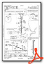
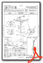
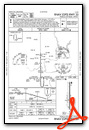
Instrument Approach Procedure (IAP) Charts
Nearby Airports with Instrument Procedures
| ID | Name | Heading / Distance | ||
|---|---|---|---|---|
 |
KBKN | Blackwell-Tonkawa Municipal Airport | 273° | 12.1 |
|
F22 | Perry Municipal Airport | 202° | 22.5 |
|
KWLD | Strother Field Airport | 006° | 26.3 |
|
O53 | Medford Municipal Airport | 276° | 31.5 |
|
KSWO | Stillwater Regional Airport | 178° | 34.2 |
|
KEGT | Wellington Municipal Airport | 338° | 38.1 |
|
KWDG | Enid Woodring Regional Airport | 237° | 39.6 |
|
KEND | Vance AFB Airport | 239° | 46.0 |
|
KCUH | Cushing Municipal Airport | 161° | 49.4 |
|
KBVO | Bartlesville Municipal Airport | 087° | 52.5 |
|
KANY | Anthony Municipal Airport | 298° | 53.6 |
|
KIAB | Mc Connell AFB Airport | 351° | 54.0 |
Airport Images
Do you have a recent image of this airport? Upload it here!


Comments
Ponce City on-field restuarant
Ponce City airport has Enrique's Mexican restaurant. Super friendly and right on the field in the terminal building under the old tower.
Good food, so instead of the $100 hamburger, try a taco or enchalada.