Login
Register


PQI
Presque Isle International Airport
Official FAA Data Effective 2024-04-18 0901Z
Chart Supplement

VFR Chart of KPQI
Sectional Charts at SkyVector.com
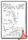
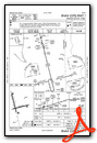
IFR Chart of KPQI
Enroute Charts at SkyVector.com
Location Information for KPQI
Coordinates: N46°41.34' / W68°2.69'Located 01 miles NW of Presque Isle, Maine on 1489 acres of land. View all Airports in Maine.
Surveyed Elevation is 534 feet MSL.
Operations Data
|
|
Airport Communications
| AWOS-3PT: | 118.025 Tel. 207-764-7248 |
|---|---|
| UNICOM: | 122.800 |
| CTAF: | 122.800 |
| ASOS at CAR (11.0 N): | 135.125 207-496-3153 |
| ASOS at HUL (35.8 S): | 132.025 207-532-1584 |
| ASOS at FVE (37.4 N): | 135.725 207-543-7456 |
- APCH/DEP SVC PRVDD BY BOSTON ARTCC ON FREQS 124.75/239.05 (CARIBOU RCAG).
- CLNC DEL PRVDD BY BOSTON ARTCC ON FREQ 121.6.
Nearby Navigation Aids
|
| ||||||||||||||||||||||||||||||||||||


Runway 01/19
| Dimensions: | 7441 x 150 feet / 2268 x 46 meters | |
|---|---|---|
| Surface: | Asphalt in Good Condition | |
| Weight Limits: | 94 /F/A/W/T, S-100, D-150, ST-240 | |
| Edge Lighting: | High Intensity | |
| Runway 01 | Runway 19 | |
| Coordinates: | N46°40.87' / W68°2.73' | N46°42.06' / W68°3.17' |
| Elevation: | 455.0 | 534.0 |
| Traffic Pattern: | Left | Left |
| Runway Heading: | 346° True | 166° True |
| Declared Distances: | TORA:7441 TODA:7441 ASDA:7441 LDA:7441 | TORA:7441 TODA:7441 ASDA:7441 LDA:7441 |
| Markings: | Precision Instrument in good condition. | Precision Instrument in good condition. |
| Glide Slope Indicator | P4L (3.70° Glide Path Angle) | |
| Approach Lights: | MALSR 1,400 Foot Medium-intensity Approach Lighting System with runway alignment indicator lights. | |
| REIL: | Yes | |
| Obstacles: | 115 ft Trees 2500 ft from runway, 425 ft left of center | |
Runway 10/28
| Dimensions: | 6000 x 100 feet / 1829 x 30 meters | |
|---|---|---|
| Surface: | Asphalt in Excellent Condition | |
| Weight Limits: | 94 /F/A/W/T, S-100, D-150, ST-240 | |
| Edge Lighting: | Medium Intensity | |
| Runway 10 | Runway 28 | |
| Coordinates: | N46°41.06' / W68°3.05' | N46°41.30' / W68°1.66' |
| Elevation: | 473.2 | 473.2 |
| Traffic Pattern: | Left | Left |
| Runway Heading: | 76° True | 256° True |
| Declared Distances: | TORA:6000 TODA:6000 ASDA:6000 LDA:6000 | TORA:6000 TODA:6000 ASDA:6000 LDA:6000 |
| Markings: | Non-Precision Instrument in good condition. | Non-Precision Instrument in good condition. |
| Glide Slope Indicator | P4L (3.00° Glide Path Angle) | |
| Obstacles: | 44 ft Tree 1300 ft from runway | 31 ft Railroad 1200 ft from runway |
Services Available
| Fuel: | 100LL (blue), Jet-A |
|---|---|
| Transient Storage: | Hangars,Tiedowns |
| Airframe Repair: | MINOR |
| Engine Repair: | MINOR |
| Bottled Oxygen: | NONE |
| Bulk Oxygen: | NONE |
| Other Services: | CROP DUSTING SERVICES,AIR AMBULANCE SERVICES,CARGO HANDLING SERVICES,CHARTER SERVICE,PILOT INSTRUCTION,AIRCRAFT RENTAL |
Ownership Information
| Ownership: | Publicly owned | |
|---|---|---|
| Owner: | CITY OF PRESQUE ISLE | |
| 12 SECOND ST | ||
| PRESQUE ISLE, ME 04769 | ||
| 207-764-4485 | ||
| Manager: | SCOTT WARDWELL | |
| 650 AIRPORT DR SUITE 11 | ||
| PRESQUE ISLE, ME 04769 | ||
| 207-764-2550 | ||
Operational Statistics
| Single Engine Aircraft Based on Field: | 17 | Statistics collected for 12 month period ending 2023-07-31 | |
|---|---|---|---|
| Multi-Engine Aircraft Based on Field: | 2 | Annual Commercial Operations: | 1222 |
| Jet Aircraft Based on Field: | 2 | Annual Commuter Operations: | none |
| Helicopters Based on Field: | none | Annual Air Taxi Operations: | 4210 |
| Military Aircraft Based on Field: | none | Annual Military Operations: | 53 |
| Gliders Based on Field: | none | Annual GA Local Operations: | 920 |
| Ultralights Based on Field: | none | Annual GA Itinerant Operations: | 1999 |
Other Remarks
- PAEW ADJ TO RWYS & TWYS (MOWING) MAY 1 THRU NOV 1.
- FOR CD CTC BOSTON ARTCC AT 603-879-6859.
- CTN SML UAS ACT FM SFC TO 400 FT AGL (1040-MSL) 3.5 NM S OF ARPT DUR DALGT HRS.
- PAPI VISUAL GA NON-STD.
- ACTVT MALSR RWY 01; REIL RWY 19; PAPI RWY 19 & 28; HIRL RWY 01/19; MIRL RWY 10/28 - 122.6.
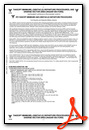
Weather Minimums
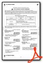
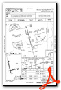
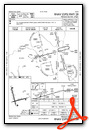
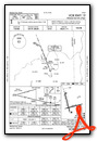
Instrument Approach Procedure (IAP) Charts
Nearby Airports with Instrument Procedures
| ID | Name | Heading / Distance | ||
|---|---|---|---|---|
 |
KCAR | Caribou Municipal Airport | 005° | 11.0 |
|
KHUL | Houlton International Airport | 162° | 35.5 |
|
KFVE | Northern Aroostook Regional Airport | 343° | 37.5 |
|
KMLT | Millinocket Municipal Airport | 203° | 68.0 |
|
KLRG | Lincoln Regional Airport | 194° | 82.2 |
|
KPNN | Princeton Municipal Airport | 167° | 91.6 |
|
3B1 | Greenville Municipal Airport | 221° | 96.8 |
|
52B | Moosehead Aero Marine Seaplane Base | 222° | 97.7 |
|
KOLD | Dewitt Field/Old Town Municipal Airport | 194° | 107.5 |
|
59B | Newton Field Airport | 236° | 111.6 |
|
1B0 | Dexter Regional Airport | 206° | 112.8 |
|
KEPM | Eastport Municipal Airport | 157° | 115.2 |
Airport Images
Do you have a recent image of this airport? Upload it here!


