Login
Register


PQL
Trent Lott International Airport
Official FAA Data Effective 2024-04-18 0901Z
Chart Supplement

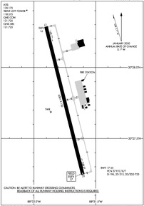
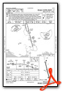
KPQL Airport Diagram
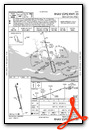
VFR Chart of KPQL
Sectional Charts at SkyVector.com
IFR Chart of KPQL
Enroute Charts at SkyVector.com
Location Information for KPQL
Coordinates: N30°27.77' / W88°31.75'Located 06 miles N of Pascagoula, Mississippi on 906 acres of land. View all Airports in Mississippi.
Surveyed Elevation is 16 feet MSL.
Operations Data
|
|
Airport Communications
| ATIS: | 135.175 |
|---|---|
| ASOS: | 135.175 Tel. 228-474-2836 |
| TRENT LOTT TOWER: | 118.575 |
| TRENT LOTT GROUND: | 121.725 |
| MOBILE APPROACH: | 121.0 307.1 |
| MOBILE DEPARTURE: | 121.0 307.1 |
| CLEARANCE DELIVERY: | 121.725 |
| CTAF: | 118.575 |
| UNICOM: | 122.800 |
| ASOS at MOB (20.2 NE): | 124.75 251-607-0469 |
| ATIS at MOB (20.2 NE): | 124.75 |
| ATIS at BIX (20.7 W): | 281.55 |
- APCH/DEP SVC PRVDD BY HOUSTON ARTCC (ZHU) ON FREQS 127.65/285.475 (MOBILE RCAG) WHEN MOBILE APCH CTL (MOB) CLSD.
Nearby Navigation Aids
|
| ||||||||||||||||||||||||||||||||||||||||||||||||||||||||||||


Runway 17/35
| Dimensions: | 6501 x 150 feet / 1982 x 46 meters | |
|---|---|---|
| Surface: | Asphalt / Grooved in Excellent Condition | |
| Weight Limits: | 57 /F/C/X/T, D-196, ST-315, DT-753
UNL.
| |
| Edge Lighting: | Medium Intensity | |
| Runway 17 | Runway 35 | |
| Coordinates: | N30°28.29' / W88°31.90' | N30°27.25' / W88°31.60' |
| Elevation: | 15.8 | 16.7 |
| Runway Heading: | 166° True | 346° True |
| Markings: | Precision Instrument in good condition. | Non-Precision Instrument in fair condition. |
| Glide Slope Indicator | P4L (3.00° Glide Path Angle) | P4L (3.00° Glide Path Angle) |
| Approach Lights: | MALSR 1,400 Foot Medium-intensity Approach Lighting System with runway alignment indicator lights. | |
Services Available
| Fuel: | 100LL (blue), Jet-A |
|---|---|
| Transient Storage: | Tiedowns |
| Airframe Repair: | MAJOR |
| Engine Repair: | MAJOR |
| Bottled Oxygen: | NOT AVAILABLE |
| Bulk Oxygen: | NOT AVAILABLE |
Ownership Information
| Ownership: | Publicly owned | |
|---|---|---|
| Owner: | JACKSON COUNTY | PAUL WILSON, JCAA CHAIRMAN. |
| 8301 SARACENNIA RD | ||
| MOSS POINT, MS 39563-9478 | ||
| 228-769-3089 | ||
| Manager: | CINNAMON SNYDER | |
| 8301 SARACENNIA RD, STE 11 | ||
| MOSS POINT, MS 39563-9478 | ||
| 228-475-1371 | IFUN TO CTC AMGR CALL FBO: 228-474-1000. | |
Operational Statistics
| Single Engine Aircraft Based on Field: | 28 | Statistics collected for 12 month period ending 2023-05-26 | |
|---|---|---|---|
| Multi-Engine Aircraft Based on Field: | 5 | Annual Commercial Operations: | none |
| Jet Aircraft Based on Field: | 3 | Annual Commuter Operations: | none |
| Helicopters Based on Field: | 2 | Annual Air Taxi Operations: | 3189 |
| Military Aircraft Based on Field: | none | Annual Military Operations: | 1234 |
| Gliders Based on Field: | none | Annual GA Local Operations: | 16758 |
| Ultralights Based on Field: | none | Annual GA Itinerant Operations: | 11606 |
Other Remarks
- NMRS LOW FLYING FISH SPOTTER ACFT OPRG NEAR SHORELINE BTN BAY ST LOUIS & PASCAGOULA SR-SS.
- ARFF 24 HRS.
- FOR CD WHEN ATCT CLSD CTC MOBILE APCH AT 251-662-6236, WHEN APCH CLSD CTC HOUSTON ARTCC AT 281-230-5622.
- 0LL MIL CONTR FUEL AVBL.
- ACTVT MALSR RWY 17; PAPI RWY 35; MIRL RWY 17/35 - CTAF.
Weather Minimums
Instrument Approach Procedure (IAP) Charts
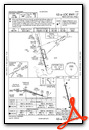
Nearby Airports with Instrument Procedures
| ID | Name | Heading / Distance | ||
|---|---|---|---|---|
 |
2R5 | St Elmo Airport | 079° | 13.4 |
|
KMOB | Mobile Regional Airport | 047° | 20.2 |
|
KBIX | Keesler AFB Airport | 261° | 20.7 |
|
KBFM | Mobile International Airport | 067° | 25.8 |
|
KGPT | Gulfport-Biloxi International Airport | 263° | 28.3 |
|
KCQF | H L Sonny Callahan Airport | 090° | 33.8 |
|
M24 | Dean Griffin Memorial Airport | 304° | 39.9 |
|
5R4 | Foley Municipal Airport | 092° | 43.0 |
|
1R8 | Bay Minette Municipal Airport | 056° | 44.1 |
|
KJKA | Gulf Shores International/Jack Edwards Field Airport | 102° | 45.7 |
|
KHSA | Stennis International Airport | 263° | 48.3 |
|
M13 | Poplarville/Pearl River County Airport | 291° | 54.1 |
Fuel Providers

Airport Images

By: jtrolinger

By: jtrolinger


