Login
Register


PRB
Paso Robles Municipal Airport
Official FAA Data Effective 2024-04-18 0901Z
Chart Supplement

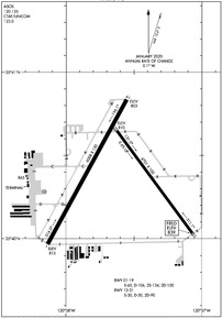
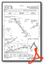
KPRB Airport Diagram
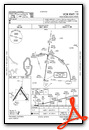
VFR Chart of KPRB
Sectional Charts at SkyVector.com
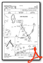
IFR Chart of KPRB
Enroute Charts at SkyVector.com
Location Information for KPRB
Coordinates: N35°40.37' / W120°37.62'Located 04 miles NE of Paso Robles, California on 1300 acres of land. View all Airports in California.
Surveyed Elevation is 838 feet MSL.
Operations Data
|
|
Airport Communications
| ASOS: | 120.125 Tel. 805-239-3593 |
|---|---|
| CTAF: | 123.000 |
| UNICOM: | 123.000 |
| ASOS at SBP (26.1 S): | 120.6 805-547-1260 |
| ATIS at SBP (26.2 S): | 120.6 |
| AWOS-3 at C80 (33.6 NE): | 119.275 559-935-5960 |
- COMMUNICATIONS PRVDD BY HAWTHORNE RADIO ON FREQS 122.4 (PASO ROBLES RCO).
- APCH/DEP CTL SVC PRVDD BY OAKLAND ARTCC (ZOA) ON FREQS 128.7/307.0 (PRIEST RCAG).
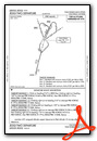
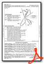
Nearby Navigation Aids
|
| ||||||||||||||||||||||||||||||||||||||||||||||||


Runway 01/19
| Dimensions: | 6008 x 150 feet / 1831 x 46 meters | |
|---|---|---|
| Surface: | Asphalt / Grooved in Good Condition | |
| Weight Limits: | S-60, D-106, ST-150 | |
| Edge Lighting: | High Intensity | |
| Runway 01 | Runway 19 | |
| Coordinates: | N35°39.97' / W120°38.13' | N35°40.84' / W120°37.55' |
| Elevation: | 814.5 | 803.4 |
| Traffic Pattern: | Left | Left |
| Runway Heading: | 29° True | 209° True |
| Markings: | Non-Precision Instrument in good condition. | Non-Precision Instrument in good condition. |
| Glide Slope Indicator | P4L (3.00° Glide Path Angle) | |
| REIL: | Yes | |
Runway 13/31
| Dimensions: | 4701 x 100 feet / 1433 x 30 meters | |
|---|---|---|
| Surface: | Asphalt in Good Condition | |
| Weight Limits: | S-30, D-50, ST-90 | |
| Edge Lighting: | Medium Intensity | |
| Runway 13 | Runway 31 | |
| Coordinates: | N35°40.65' / W120°37.63' | N35°40.03' / W120°37.06' |
| Elevation: | 810.0 | 838.7 |
| Traffic Pattern: | Left | Left |
| Runway Heading: | 144° True | 324° True |
| Markings: | Non-Precision Instrument in good condition. | Non-Precision Instrument in good condition. |
| Glide Slope Indicator | P4L (3.00° Glide Path Angle) | |
| Obstacles: | 54 ft Tree 1950 ft from runway | |
Helipad H1
| Dimensions: | 100 x 100 feet / 30 x 30 meters | |
|---|---|---|
| Surface: | Asphalt in Excellent Condition | |
| Edge Lighting: | Perimeter | |
| Markings: | in good condition. | |
Services Available
| Fuel: | 100LL (blue), Jet-A |
|---|---|
| Transient Storage: | Tiedowns |
| Airframe Repair: | MINOR |
| Engine Repair: | MINOR |
| Bottled Oxygen: | LOW |
| Bulk Oxygen: | NOT AVAILABLE |
| Other Services: | PILOT INSTRUCTION,AIRCRAFT RENTAL |
Ownership Information
| Ownership: | Publicly owned | |
|---|---|---|
| Owner: | CITY OF PASO ROBLES | |
| 1000 SPRING ST. | ||
| PASO ROBLES, CA 93446 | ||
| 805-237-3861 | ||
| Manager: | MARK W. SCANDALIS | |
| 4912 WING WAY | ||
| PASO ROBLES, CA 93446 | ||
| 805-237-3877 | ||
Operational Statistics
| Single Engine Aircraft Based on Field: | 163 | Statistics collected for 12 month period ending 2023-09-29 | |
|---|---|---|---|
| Multi-Engine Aircraft Based on Field: | 14 | Annual Commercial Operations: | none |
| Jet Aircraft Based on Field: | 3 | Annual Commuter Operations: | none |
| Helicopters Based on Field: | 8 | Annual Air Taxi Operations: | 3000 |
| Military Aircraft Based on Field: | none | Annual Military Operations: | 2500 |
| Gliders Based on Field: | 2 | Annual GA Local Operations: | 25000 |
| Ultralights Based on Field: | none | Annual GA Itinerant Operations: | 13500 |
Other Remarks
- PPR FOR AIRCRAFT OVER 80,000 LBS. CONTACT AMGR 805-237-3877
- RWY 19 DSGND CALM WIND RWY.
- FOR CD IF UNA TO CTC ON FSS FREQ, CTC OAKLAND ARTCC AT 510-745-3380.
- V22 OSPREY ARPT OPS RSTRD TO BTN 0700 TO 1530 LOCAL.
- V22 OSPREY OPS PPR RQRD.
- STANDARD HELIPAD MARKINGS.
- RY LGTS OPER DUSK-2200; AFTER 2200 ACTVT HIRL RY 01/19 MIRL RY 13/31 PAPI RYS 19 & 31, RY H1 PERIMETER LGTS - CTAF.
Weather Minimums
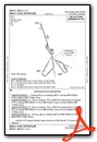
Instrument Approach Procedure (IAP) Charts
Departure Procedure Obstacles (DPO) Charts
Nearby Airports with Instrument Procedures
| ID | Name | Heading / Distance | ||
|---|---|---|---|---|
 |
KSBP | San Luis Obispo County Regional Airport | 181° | 26.1 |
|
C80 | New Coalinga Municipal Airport | 028° | 33.5 |
|
KSMX | Santa Maria Pub/Capt G Allan Hancock Field Airport | 169° | 47.0 |
|
KVBG | Vandenberg Space Force Base Airport | 177° | 56.1 |
|
KLPC | Lompoc Airport | 172° | 60.8 |
|
KHJO | Hanford Municipal Airport | 051° | 62.1 |
|
KDLO | Delano Municipal Airport | 085° | 68.1 |
|
KIZA | Santa Ynez/Kunkle Field Airport | 156° | 69.4 |
|
KTLR | Mefford Field Airport | 065° | 69.7 |
|
KMIT | Shafter-Minter Field Airport | 097° | 70.9 |
|
KVIS | Visalia Municipal Airport | 056° | 71.5 |
|
F34 | Firebaugh Airport | 006° | 71.6 |
Airport Images

By: www.focalflight.com

By: helicopter mech


