Login
Register


PTV
Porterville Municipal Airport
Official FAA Data Effective 2024-04-18 0901Z
Chart Supplement

VFR Chart of KPTV
Sectional Charts at SkyVector.com
IFR Chart of KPTV
Enroute Charts at SkyVector.com
Location Information for KPTV
Coordinates: N36°1.77' / W119°3.76'Located 03 miles SW of Porterville, California on 940 acres of land. View all Airports in California.
Surveyed Elevation is 443 feet MSL.
Operations Data
|
|
Airport Communications
| AWOS-3PT: | 134.625 Tel. 559-784-3874 |
|---|---|
| BAKERSFIELD APPROACH: | 120.5 |
| BAKERSFIELD DEPARTURE: | 120.5 |
| CTAF: | 122.800 |
| UNICOM: | 122.800 |
| AWOS-3PT at TLR (15.2 NW): | 120.0 559-686-2613 |
| AWOS-3P at DLO (19.1 SW): | 119.55 661-721-2668 |
| AWOS-3PT at VIS (23.2 NW): | 119.925 559-651-2418 |
- APCH/DEP CTL SVC PRVDD BY LOS ANGELES ARTCC (ZLA) ON FREQS 127.1/317.7 (BAKERSFIELD RCAG) WHEN BAKERSFIELD APCH CTL (BFL) CLSD.
- COMMUNICATIONS PRVDD BY RANCHO MURIETA RADIO ON FREQS 122.1R/109.2T (TULE RCO).
Nearby Navigation Aids
|
| ||||||||||||||||||||||||||||||||||||||||||


Runway 12/30
| Dimensions: | 5960 x 150 feet / 1817 x 46 meters | |
|---|---|---|
| Surface: | Asphalt / Grooved in Good Condition | |
| Weight Limits: | S-30, D-70, ST-110 | |
| Edge Lighting: | High Intensity | |
| Runway 12 | Runway 30 | |
| Coordinates: | N36°2.12' / W119°4.19' | N36°1.43' / W119°3.34' |
| Elevation: | 431.2 | 443.1 |
| Traffic Pattern: | Left | Left |
| Runway Heading: | 135° True | 315° True |
| Markings: | Non-Precision Instrument in fair condition. | Non-Precision Instrument in fair condition. |
| Glide Slope Indicator | V4R (3.00° Glide Path Angle) | V4R (3.00° Glide Path Angle) |
| REIL: | Yes | |
| Obstacles: | 15 ft Road 480 ft from runway, 292 ft left of center | 15 ft Road 520 ft from runway, 298 ft left of center |
Services Available
| Fuel: | 100LL (blue), Jet-A |
|---|---|
| Transient Storage: | Tiedowns |
| Airframe Repair: | MAJOR |
| Engine Repair: | MAJOR |
| Bottled Oxygen: | NONE |
| Bulk Oxygen: | NOT AVAILABLE |
| Other Services: | CHARTER SERVICE,PILOT INSTRUCTION,AIRCRAFT RENTAL,AIRCRAFT SALES,ANNUAL SURVEYING |
Ownership Information
| Ownership: | Publicly owned | |
|---|---|---|
| Owner: | CITY OF PORTERVILLE | |
| 291 N. MAIN STREET | ||
| PORTERVILLE, CA 93257-7466 | ||
| 559-782-7540 | ||
| Manager: | ANDRE LABONTE | ARPT OPERATIONS MANGER: JIM MCDONALD; PHONE (559) 782-7540. |
| 1893 SOUTH NEWCOMB ROAD | EMERGENCY CONTACT PORTERVILLE PD 559-782-7400 | |
| PORTERVILLE, CA 93257-7466 | ||
| 559-782-7540 | ||
Operational Statistics
| Single Engine Aircraft Based on Field: | 31 | Statistics collected for 12 month period ending 2023-06-21 | |
|---|---|---|---|
| Multi-Engine Aircraft Based on Field: | 1 | Annual Commercial Operations: | none |
| Jet Aircraft Based on Field: | none | Annual Commuter Operations: | none |
| Helicopters Based on Field: | 4 | Annual Air Taxi Operations: | 1000 |
| Military Aircraft Based on Field: | none | Annual Military Operations: | 50 |
| Gliders Based on Field: | none | Annual GA Local Operations: | 15000 |
| Ultralights Based on Field: | none | Annual GA Itinerant Operations: | 27500 |
Other Remarks
- 0LL SELF SERVICE FUEL AVBL 24 HRS WITH CREDIT CARD.
- HIRL RY 12/30 PRESET LOW INTST DUSK-2300; AFTER 2300 ACTVT - CTAF. ACTVT VASI RY 12 - CTAF, VASI RY 30 OPER CONTINUOUSLY.
Weather Minimums
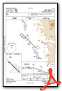
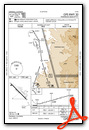
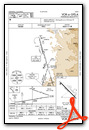
Instrument Approach Procedure (IAP) Charts
Nearby Airports with Instrument Procedures
| ID | Name | Heading / Distance | ||
|---|---|---|---|---|
 |
KTLR | Mefford Field Airport | 300° | 14.9 |
|
KDLO | Delano Municipal Airport | 206° | 19.0 |
|
KVIS | Visalia Municipal Airport | 317° | 23.6 |
|
KMIT | Shafter-Minter Field Airport | 191° | 31.9 |
|
KHJO | Hanford Municipal Airport | 302° | 32.4 |
|
KBFL | Meadows Field Airport | 179° | 35.7 |
|
L45 | Bakersfield Municipal Airport | 175° | 42.3 |
|
O32 | Reedley Municipal Airport | 334° | 42.8 |
|
KFAT | Fresno Yosemite International Airport | 324° | 54.9 |
|
KFCH | Fresno Chandler Exec Airport | 319° | 55.8 |
|
C80 | New Coalinga Municipal Airport | 277° | 60.4 |
|
KIYK | Inyokern Airport | 109° | 64.1 |
Airport Images

By: Skydog222

By: Skydog222


