Login
Register


PUC
Carbon County Regional/Buck Davis Field Airport
Official FAA Data Effective 2024-04-18 0901Z
Chart Supplement

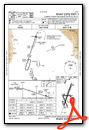
VFR Chart of KPUC
Sectional Charts at SkyVector.com
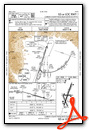
IFR Chart of KPUC
Enroute Charts at SkyVector.com
Location Information for KPUC
Coordinates: N39°36.83' / W110°45.10'Located 03 miles E of Price, Utah on 1147 acres of land. View all Airports in Utah.
Surveyed Elevation is 5957 feet MSL.
Operations Data
|
|
Airport Communications
| ASOS: | 135.425 Tel. 435-637-2790 |
|---|---|
| UNICOM: | 122.800 |
| CTAF: | 122.800 |
| AWOS-3 at U69 (38.9 NE): | 121.125 435-738-0353 |
| AWOS-3PT at 41U (43.4 W): | 120.025 435-283-4624 |
| AWOS-3P at 74V (51.4 NE): | 118.975 435-722-4201 |
- APCH/DEP CTL SVC PRVDD BY SALT LAKE ARTCC (ZLC) ON FREQS 133.9/370.85 (SUNNYSIDE RCAG).
Nearby Navigation Aids
|
| ||||||||||||||||||||||||||||||||||||


Runway 01/19
| Dimensions: | 8316 x 100 feet / 2535 x 30 meters | |
|---|---|---|
| Surface: | Asphalt / Grooved in Excellent Condition | |
| Weight Limits: | 18 /F/B/X/U, S-30, D-40 | |
| Edge Lighting: | High Intensity | |
| Runway 01 | Runway 19 | |
| Coordinates: | N39°36.30' / W110°45.31' | N39°37.59' / W110°44.76' |
| Elevation: | 5811.7 | 5957.6 |
| Traffic Pattern: | Left | Left |
| Runway Heading: | 18° True | 198° True |
| Markings: | Precision Instrument in good condition. | Basic in good condition. |
| Glide Slope Indicator | P4L (3.00° Glide Path Angle) | P2L (4.00° Glide Path Angle) PAPI UNUSBL BYD 3 NM DUE TO TRRN; BYD 9 DEGS RIGHT OF CNTRLN. |
| Approach Lights: | MALSF 1,400 Foot Medium-intensity Approach Lighting System with sequenced flashers. | |
| REIL: | Yes | |
Runway 15/33
| Dimensions: | 4513 x 75 feet / 1376 x 23 meters | |
|---|---|---|
| Surface: | Asphalt in Fair Condition | |
| Weight Limits: | 13 /F/B/X/U, S-13 | |
| Edge Lighting: | Medium Intensity | |
| Runway 15 | Runway 33 | |
| Coordinates: | N39°36.92' / W110°45.40' | N39°36.23' / W110°45.06' |
| Elevation: | 5860.6 | 5812.6 |
| Traffic Pattern: | Left | Left |
| Runway Heading: | 158° True | 338° True |
| Markings: | Basic in fair condition. | Basic in fair condition. |
| Obstacles: | ft Road ft from runway | |
Runway 08/26
| Dimensions: | 3151 x 75 feet / 960 x 23 meters | |
|---|---|---|
| Surface: | Asphalt in Good Condition | |
| Weight Limits: | 3 /F/B/Z/U, S-12 | |
| Runway 08 | Runway 26 | |
| Coordinates: | N39°36.91' / W110°45.40' | N39°36.91' / W110°44.73' |
| Elevation: | 5859.3 | 5890.5 |
| Traffic Pattern: | Left | Left |
| Runway Heading: | 90° True | 270° True |
| Displaced Threshold: | 128 Feet | |
| Markings: | Basic in good condition. | Basic in good condition. |
| Glide Slope Indicator | P2L (3.00° Glide Path Angle) | P2L (3.00° Glide Path Angle) |
| REIL: | Yes | Yes |
| Obstacles: | ft Road ft from runway | |
Services Available
| Fuel: | 100LL (blue), Jet-A |
|---|---|
| Transient Storage: | Hangars,Tiedowns |
| Airframe Repair: | MINOR |
| Engine Repair: | MINOR |
| Bottled Oxygen: | NONE |
| Bulk Oxygen: | NONE |
| Other Services: | AIR FREIGHT SERVICES,PILOT INSTRUCTION |
Ownership Information
| Ownership: | Publicly owned | |
|---|---|---|
| Owner: | CARBON COUNTY | |
| 751 E 100 N | ||
| PRICE, UT 84501 | ||
| 435-636-3201 | ||
| Manager: | GARY SPRINGER | |
| 3095 AIRPORT ROAD, 3095 EAST AIRPORT ROAD | ||
| PRICE, UT 84501 | ||
| 435-637-9556 | ||
Operational Statistics
| Single Engine Aircraft Based on Field: | 14 | Statistics collected for 12 month period ending 2023-09-28 | |
|---|---|---|---|
| Multi-Engine Aircraft Based on Field: | none | Annual Commercial Operations: | none |
| Jet Aircraft Based on Field: | none | Annual Commuter Operations: | none |
| Helicopters Based on Field: | none | Annual Air Taxi Operations: | 104 |
| Military Aircraft Based on Field: | none | Annual Military Operations: | none |
| Gliders Based on Field: | none | Annual GA Local Operations: | 2700 |
| Ultralights Based on Field: | none | Annual GA Itinerant Operations: | 2700 |
Other Remarks
- FOR CD IF UNA TO CTC ON FSS FREQ, CTC SALT LAKE ARTCC AT 801-320-2568.
- RWY 15, 20 FT DROP OFF, 200 FT FM THLD.
- RWY 08, 60 FT DROP OFF, 520 FT FM RWY END.
- 0LL 24 HR SELF SVC FUEL AVBL WITH CREDIT CARD.
- ACTVT MALSF RWY 01; REIL RWY 19, 08 & 26; PAPI RWY 01 & 19, 08 & 26; HIRL RWY 01/19; MIRL RWY 15/33 - CTAF.
Weather Minimums
Instrument Approach Procedure (IAP) Charts
Nearby Airports with Instrument Procedures
| ID | Name | Heading / Distance | ||
|---|---|---|---|---|
 |
69V | Huntington Municipal Airport | 206° | 17.0 |
|
41U | Manti-Ephraim Airport | 247° | 43.4 |
|
74V | Roosevelt Municipal Airport | 038° | 51.3 |
|
U14 | Nephi Municipal Airport | 278° | 52.3 |
|
KSPK | Spanish Fork Municipal/Woodhouse Field Airport | 307° | 53.0 |
|
KPVU | Provo Municipal Airport | 309° | 57.7 |
|
KHCR | Heber Valley Airport | 329° | 60.7 |
|
KCNY | Canyonlands Regional Airport | 137° | 69.3 |
|
KVEL | Vernal Regional Airport | 048° | 75.5 |
|
KRIF | Richfield Municipal Airport | 230° | 82.2 |
|
KDTA | Delta Municipal Airport | 260° | 82.5 |
|
U42 | South Valley Regional Airport | 316° | 83.1 |
Airport Images
Do you have a recent image of this airport? Upload it here!


Comments
Runway and Markings changes
I'm with airport management here in PUC and the publications for my airport haven't been updated for over a year. We have two brand new runways and the designations have changed as well. All runway designators changed by one degree as explained in the NOTAMS. 7/25 has been rehabilitated and is a great little runway and our main runway, 18/36, was also rehabilitated and its amazing. We upgraded to pilot controlled lighting and all runways are lighted. Come see us if you're headed our way!
Posted Fuel Prices
Redtail Aviation doesn't keep the posted fuel prices updated. I just paid $4.97 per gallon for 100LL when the price on this website showed it at $4.35 per gallon.
The price has been updated. Thank you