Login
Register


RBG
Roseburg Regional Airport
Official FAA Data Effective 2024-04-18 0901Z
Chart Supplement

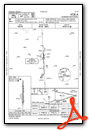
VFR Chart of KRBG
Sectional Charts at SkyVector.com
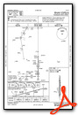
IFR Chart of KRBG
Enroute Charts at SkyVector.com
Location Information for KRBG
Coordinates: N43°14.36' / W123°21.35'Located 01 miles NW of Roseburg, Oregon on 200 acres of land. View all Airports in Oregon.
Surveyed Elevation is 533 feet MSL.
Operations Data
|
|
Airport Communications
| ASOS: | 135.475 Tel. 541-673-1483 |
|---|---|
| UNICOM: | 122.800 |
| CTAF: | 122.800 |
| ASOS at SXT (38.4 S): | 118.375 541-471-1460 |
| AWOS-3PT at OTH (40.4 W): | 135.075 541-756-0135 |
| AWOS-3PT at 3S8 (43.9 S): | 120.0 541-955-3392 |
- APCH/DEP CTL SVC PRVDD BY SEATTLE ARTCC (ZSE) ON FREQS 127.55/239.0 (HORTON RCAG).
Nearby Navigation Aids
|
| ||||||||||||||||||||||||||||||||||||||||||


Runway 16/34
| Dimensions: | 5003 x 100 feet / 1525 x 30 meters | |
|---|---|---|
| Surface: | Asphalt in Fair Condition | |
| Weight Limits: | S-42, D-54, ST-88 | |
| Edge Lighting: | Medium Intensity | |
| Runway 16 | Runway 34 | |
| Coordinates: | N43°14.77' / W123°21.35' | N43°13.95' / W123°21.35' |
| Elevation: | 533.4 | 500.8 |
| Traffic Pattern: | Left | Left |
| Runway Heading: | 180° True | 360° True |
| Displaced Threshold: | 1100 Feet | 372 Feet |
| Markings: | Non-Precision Instrument in fair condition. | Non-Precision Instrument in fair condition. |
| Glide Slope Indicator | P4R (4.00° Glide Path Angle) | |
| REIL: | Yes | Yes |
| Obstacles: | 26 ft Hill 380 ft from runway, 250 ft left of center 14:1 BASED ON DSPLCD THR. |
20 ft Road 220 ft from runway, 250 ft left of center 19:1 BASED ON DTHR. |
Services Available
| Fuel: | 100LL (blue), Jet-A |
|---|---|
| Transient Storage: | Tiedowns |
| Airframe Repair: | MAJOR |
| Engine Repair: | MAJOR |
| Bottled Oxygen: | NONE |
| Bulk Oxygen: | HIGH |
| Other Services: | CHARTER SERVICE,PILOT INSTRUCTION,AIRCRAFT RENTAL |
Ownership Information
| Ownership: | Publicly owned | |
|---|---|---|
| Owner: | CITY OF ROSEBURG | |
| CITY HALL | ||
| ROSEBURG, OR 97470 | ||
| 541-672-7701 | ||
| Manager: | NIKKI MESSENGER | |
| 900 SE DOUGLAS | ||
| ROSEBURG, OR 97470 | ||
| 541-672-7701 | ||
Operational Statistics
| Single Engine Aircraft Based on Field: | 58 | Statistics collected for 12 month period ending 2019-11-20 | |
|---|---|---|---|
| Multi-Engine Aircraft Based on Field: | 2 | Annual Commercial Operations: | none |
| Jet Aircraft Based on Field: | 4 | Annual Commuter Operations: | none |
| Helicopters Based on Field: | 1 | Annual Air Taxi Operations: | 2550 |
| Military Aircraft Based on Field: | none | Annual Military Operations: | 50 |
| Gliders Based on Field: | none | Annual GA Local Operations: | 11660 |
| Ultralights Based on Field: | 1 | Annual GA Itinerant Operations: | 17490 |
Other Remarks
- WATERFOWL ON & INVOF ARPT.
- +700 TO 1200 FT TRRN SRND ARPT WI 2 MI.
- FOR CD IF UNA TO CTC ON FSS FREQ, CTC SEATTLE ARTCC AT 253-351-3694.
- 150 FT BLAST PAD MARKED WITH YELLOW CHEVRONS.
- ACTVT REIL RWY 16 & 34; MIRL RWY 16/34 - CTAF. RWY 34 PAPI OPR CONSLY.
Weather Minimums
Instrument Approach Procedure (IAP) Charts
Nearby Airports with Instrument Procedures
| ID | Name | Heading / Distance | ||
|---|---|---|---|---|
 |
KOTH | Southwest Oregon Regional Airport | 285° | 40.5 |
|
3S8 | Grants Pass Airport | 181° | 43.8 |
|
77S | Hobby Field Airport | 020° | 44.2 |
|
KEUG | Mahlon Sweet Field Airport | 006° | 53.5 |
|
KMFR | Rogue Valley International - Medford Airport | 157° | 56.1 |
|
4S1 | Gold Beach Municipal Airport | 224° | 68.3 |
|
KCVO | Corvallis Municipal Airport | 002° | 75.5 |
|
KBOK | Brookings Airport | 210° | 81.2 |
|
S12 | Albany Municipal Airport | 008° | 84.9 |
|
KONP | Newport Municipal Airport | 339° | 86.0 |
|
S21 | Sunriver Airport | 064° | 91.4 |
|
KCEC | Jack Mc Namara Field Airport | 204° | 95.8 |
Airport Images

By: Barnstormers Bi...

By: blendy


