Login
Register


RBW
Lowcountry Regional Airport
Official FAA Data Effective 2024-04-18 0901Z
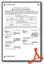
Chart Supplement

VFR Chart of KRBW
Sectional Charts at SkyVector.com
IFR Chart of KRBW
Enroute Charts at SkyVector.com
Location Information for KRBW
Coordinates: N32°55.26' / W80°38.44'Located 02 miles NE of Walterboro, South Carolina on 1400 acres of land. View all Airports in South Carolina.
Surveyed Elevation is 100 feet MSL.
Operations Data
|
|
Airport Communications
| AWOS-3PT: | 118.725 Tel. 843-538-3575 |
|---|---|
| CHARLESTON APPROACH: | 120.7 306.925 |
| CHARLESTON DEPARTURE: | 120.7 306.925 |
| CTAF: | 122.800 |
| UNICOM: | 122.800 |
| AWOS-3 at DYB (20.0 NE): | 119.575 843-821-8403 |
| ATIS at NBC (26.7 S): | 279.525 |
| D-ATIS at CHS (30.3 E): | 124.75 |
Nearby Navigation Aids
|
| ||||||||||||||||||||||||||||||||||||||||||||||||||||||||||||


Runway 05/23
| Dimensions: | 6002 x 100 feet / 1829 x 30 meters | |
|---|---|---|
| Surface: | Asphalt-Concrete in Good Condition | |
| Weight Limits: | 26 /F/B/X/T, S-70, D-101 | |
| Edge Lighting: | Medium Intensity | |
| Runway 05 | Runway 23 | |
| Coordinates: | N32°54.94' / W80°38.72' | N32°55.65' / W80°37.90' |
| Elevation: | 89.4 | 100.9 |
| Traffic Pattern: | Left | Left |
| Runway Heading: | 44° True | 224° True |
| Markings: | Non-Precision Instrument in good condition. | Precision Instrument in good condition. |
| Glide Slope Indicator | P2L (3.50° Glide Path Angle) | P2L (3.00° Glide Path Angle) |
| Approach Lights: | ODALS Omnidirectional Approach Lighting System | |
| REIL: | Yes | |
| Obstacles: | 82 ft Trees 1999 ft from runway, 265 ft right of center | 83 ft Trees 2527 ft from runway, 823 ft left of center |
Runway 17/35
| Dimensions: | 5705 x 100 feet / 1739 x 30 meters | |
|---|---|---|
| Surface: | Asphalt-Concrete in Excellent Condition | |
| Weight Limits: | 10 /F/B/X/T, S-33, D-50 | |
| Runway 17 | Runway 35 | |
| Coordinates: | N32°55.68' / W80°38.70' | N32°54.77' / W80°38.43' |
| Elevation: | 82.3 | 91.6 |
| Traffic Pattern: | Left | Left |
| Runway Heading: | 166° True | 346° True |
| Markings: | Non-Precision Instrument in good condition. | Non-Precision Instrument in good condition. |
| Obstacles: | 17 ft Tree 233 ft from runway, 74 ft left of center | 57 ft Tree 2370 ft from runway, 43 ft left of center |
Runway 09/27
RWY 09/27 CLSD PERMLY. | ||
| Dimensions: | 5408 x 100 feet / 1648 x 30 meters | |
|---|---|---|
| Surface: | Asphalt-Concrete in Failed Condition | |
| Weight Limits: | S-17, D-40 | |
| Runway 09 | Runway 27 | |
| Coordinates: | N32°55.25' / W80°38.97' | N32°55.27' / W80°37.91' |
| Elevation: | 80.9 | 92.2 |
| Traffic Pattern: | Left | Left |
| Runway Heading: | 89° True | 269° True |
| Markings: | Basic in poor condition. | Basic in poor condition. |
| Obstacles: | 52 ft Trees 637 ft from runway, 176 ft right of center | |
Services Available
| Fuel: | 100LL (blue), Jet-A |
|---|---|
| Transient Storage: | Hangars,Tiedowns |
| Airframe Repair: | MAJOR |
| Engine Repair: | MAJOR |
| Bottled Oxygen: | NONE |
| Bulk Oxygen: | NONE |
| Other Services: | PILOT INSTRUCTION,PARACHUTE JUMP ACTIVITY |
Ownership Information
| Ownership: | Publicly owned | |
|---|---|---|
| Owner: | CITY OF WALTERBORO AND COLLETON CO. | |
| 537 AVIATION WAY | ||
| WALTERBORO, SC 29488 | ||
| 843-549-2549 | ||
| Manager: | BERT DUFFIE | |
| 537 AVIATION WAY | ||
| WALTERBORO, SC 29488 | ||
| 843-955-0290 | ||
Operational Statistics
| Single Engine Aircraft Based on Field: | 30 | Statistics collected for 12 month period ending 2023-05-19 | |
|---|---|---|---|
| Multi-Engine Aircraft Based on Field: | 8 | Annual Commercial Operations: | none |
| Jet Aircraft Based on Field: | 1 | Annual Commuter Operations: | none |
| Helicopters Based on Field: | none | Annual Air Taxi Operations: | 4040 |
| Military Aircraft Based on Field: | none | Annual Military Operations: | 620 |
| Gliders Based on Field: | none | Annual GA Local Operations: | 8601 |
| Ultralights Based on Field: | none | Annual GA Itinerant Operations: | 15387 |
Other Remarks
- FOR CD CTC CHARLESTON APCH AT 843 414-2832.
- DEER ON AND INVOF ARPT WITH INCR ACT DRG NGT AND AT DUSK AND DAWN.
- 0LL 100LL SELF-SVC FUEL AVBL 24 HRS.
- FOR AFT HRS SVC CALL 843-549-2549.
- ODALS RWY 23; MIRLS RWY 05/23; OPR CONSLY FM DUSK-2200. 2200 TO DAWN - CTAF.
Weather Minimums

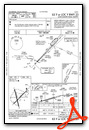
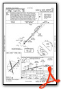
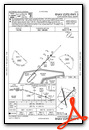
Instrument Approach Procedure (IAP) Charts
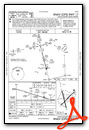

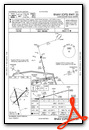
Nearby Airports with Instrument Procedures
| ID | Name | Heading / Distance | ||
|---|---|---|---|---|
 |
6J2 | St George Airport | 022° | 17.7 |
|
KDYB | Summerville Airport | 064° | 20.0 |
|
KCHS | Charleston AFB/International Airport | 092° | 30.3 |
|
KARW | Beaufort Exec Airport | 179° | 30.5 |
|
KAQX | Allendale County Airport | 278° | 32.1 |
|
99N | Bamberg County Airport | 314° | 32.9 |
|
KOGB | Orangeburg Municipal Airport | 341° | 33.9 |
|
KMKS | Berkeley County Airport | 062° | 34.3 |
|
KJZI | Charleston Exec Airport | 112° | 34.8 |
|
KHXD | Hilton Head Airport | 183° | 41.8 |
|
KBNL | Barnwell Regional Airport | 298° | 42.7 |
|
KLRO | Mt Pleasant Regional-Faison Field Airport | 091° | 43.3 |
Fuel Providers

Airport Images
Do you have a recent image of this airport? Upload it here!


