Login
Register


RCM
Skyhaven Airport
Official FAA Data Effective 2024-04-18 0901Z
Chart Supplement

VFR Chart of KRCM
Sectional Charts at SkyVector.com
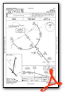
IFR Chart of KRCM
Enroute Charts at SkyVector.com
Location Information for KRCM
Coordinates: N38°47.05' / W93°48.17'Located 03 miles NW of Warrensburg, Missouri on 402 acres of land. View all Airports in Missouri.
Surveyed Elevation is 797 feet MSL.
Operations Data
|
|
Airport Communications
| AWOS-3PT: | 119.575 Tel. 660-422-7010 |
|---|---|
| WHITEMAN APPROACH: | 127.45 284.0 |
| WHITEMAN DEPARTURE: | 125.925 343.65 |
| CTAF: | 123.000 |
| UNICOM: | 123.000 |
| ATIS at SZL (12.4 E): | 239.025 |
| AWOS-3PT at GLY (26.3 S): | 120.475 660-885-3851 |
| AWOS-3PT at LRY (27.5 W): | 119.975 816-380-5936 |
- APCH/DEP SVC PRVDD BY KANSAS CITY ARTCC ON FREQS 135.575/323.15 (KNOB NOSTER RCAG) WHEN WHITEMAN APCH CTL CLSD.
Nearby Navigation Aids
|
| ||||||||||||||||||||||||||||||||||||||||||||||||||||||||||||


Runway 01/19
| Dimensions: | 4206 x 75 feet / 1282 x 23 meters | |
|---|---|---|
| Surface: | Concrete in Good Condition | |
| Weight Limits: | S-21, D-26 | |
| Edge Lighting: | Medium Intensity | |
| Runway 01 | Runway 19 | |
| Coordinates: | N38°46.83' / W93°48.21' | N38°47.51' / W93°48.09' |
| Elevation: | 788.3 | 795.3 |
| Traffic Pattern: | Left | Right |
| Runway Heading: | 8° True | 188° True |
| Markings: | Non-Precision Instrument in good condition. | Non-Precision Instrument in good condition. |
| Glide Slope Indicator | P4L (3.00° Glide Path Angle) | P4L (3.00° Glide Path Angle) |
| REIL: | Yes | Yes |
| Obstacles: | 39 ft Trees 700 ft from runway, 165 ft left of center | |
Runway 14/32
| Dimensions: | 2801 x 60 feet / 854 x 18 meters | |
|---|---|---|
| Surface: | Asphalt in Good Condition | |
| Weight Limits: | S-12 | |
| Edge Lighting: | Medium Intensity | |
| Runway 14 | Runway 32 | |
| Coordinates: | N38°47.04' / W93°48.41' | N38°46.70' / W93°48.01' |
| Elevation: | 797.9 | 785.6 |
| Traffic Pattern: | Right | Left |
| Runway Heading: | 137° True | 317° True |
| Markings: | Basic in fair condition. | Basic in fair condition. |
| REIL: | Yes | Yes |
| Obstacles: | 20 ft Trees 480 ft from runway, 98 ft right of center | 15 ft Road 375 ft from runway, 125 ft right of center |
Services Available
| Fuel: | 100LL (blue), Jet-A |
|---|---|
| Transient Storage: | Tiedowns |
| Airframe Repair: | MINOR |
| Engine Repair: | MINOR |
| Bottled Oxygen: | NONE |
| Bulk Oxygen: | NONE |
| Other Services: | CHARTER SERVICE,GLIDER SERVICE,PILOT INSTRUCTION,AIRCRAFT RENTAL,ANNUAL SURVEYING,GLIDER TOWING SERVICES |
Ownership Information
| Ownership: | Publicly owned | |
|---|---|---|
| Owner: | UNIV. OF CENTRAL MISSOURI | |
| T.R. GAINES, BLDG 210 | ||
| WARRENSBURG, MO 64093 | ||
| 660-543-4921 | ||
| Manager: | DAN DIETZ | |
| UNIVERSITY OF CENTRAL MISSOURI, 281 N.W. 50 HWY | ||
| WARRENSBURG, MO 64093 | ||
| 660-422-1110 | 660-422-1110 | |
Operational Statistics
| Single Engine Aircraft Based on Field: | 49 | Statistics collected for 12 month period ending 2019-12-31 | |
|---|---|---|---|
| Multi-Engine Aircraft Based on Field: | 3 | Annual Commercial Operations: | none |
| Jet Aircraft Based on Field: | none | Annual Commuter Operations: | none |
| Helicopters Based on Field: | none | Annual Air Taxi Operations: | 25 |
| Military Aircraft Based on Field: | none | Annual Military Operations: | 300 |
| Gliders Based on Field: | 1 | Annual GA Local Operations: | 27000 |
| Ultralights Based on Field: | none | Annual GA Itinerant Operations: | 2400 |
Other Remarks
- SOUTH 100 FT OF APRON & EXIT RAMP LCTD 1250 FT N OF RWY 01 THR HAS SAME PAVEMENT STRENGTH AS RWY 01/19; REMAINDER OF APRON NOT FULL STRENGTH.
- LIMITED SIGHT DSTC FM RWY 14 THR AREA TO RWY 19 THR AND FM RWY 19 THR TO RWY 32 THR AREA.
- HIGH VOL STUDENT TRNG INVOF ARPT FM 0700-1730 LCL MON THRU FRI.
- FOR CD CTC WHITEMAN APCH AT 660-687-3132. WHEN WHITEMAN APCH IS CLSD, CTC KANSAS CITY ARTCC AT 913-254-8508.
- CALM WIND RWY.
- ACTVT REIL RWY 14 & 32; PAPI RWY 01 & 19; MIRL RWY 01/19 & 14/32 - CTAF.
Weather Minimums
Instrument Approach Procedure (IAP) Charts
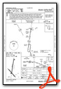
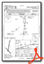
Nearby Airports with Instrument Procedures
| ID | Name | Heading / Distance | ||
|---|---|---|---|---|
 |
KSZL | Whiteman AFB Airport | 105° | 12.4 |
|
KHIG | Higginsville Industrial Municipal Airport | 018° | 18.3 |
|
3GV | East Kansas City Airport | 305° | 23.7 |
|
KGLY | Clinton Regional Airport | 167° | 26.4 |
|
KLRY | Lawrence Smith Memorial Airport | 247° | 27.5 |
|
KLXT | Lee's Summit Municipal Airport | 291° | 28.7 |
|
KDMO | Sedalia Regional Airport | 098° | 29.8 |
|
KMHL | Marshall Memorial Municipal Airport | 056° | 33.7 |
|
KRAW | Warsaw Municipal Airport | 140° | 33.9 |
|
3EX | Excelsior Springs Memorial Airport | 331° | 37.9 |
|
KBUM | Butler Memorial Airport | 220° | 39.0 |
|
KGPH | Midwest Ntl Air Center Airport | 324° | 40.5 |
Airport Images
Do you have a recent image of this airport? Upload it here!


