Login
Register


RCX
Rusk County Airport
Official FAA Data Effective 2024-04-18 0901Z
Chart Supplement

VFR Chart of KRCX
Sectional Charts at SkyVector.com
IFR Chart of KRCX
Enroute Charts at SkyVector.com
Location Information for KRCX
Coordinates: N45°29.80' / W91°0.01'Located 04 miles NE of Ladysmith, Wisconsin on 240 acres of land. View all Airports in Wisconsin.
Surveyed Elevation is 1239 feet MSL.
Operations Data
|
|
Airport Communications
| AWOS-3: | 118.125 Tel. 715-532-2665 |
|---|---|
| UNICOM: | 122.800 |
| CTAF: | 122.800 |
| AWOS-3 at PBH (28.2 NE): | 125.875 715-339-4520 |
| AWOS-3P at Y23 (29.1 W): | 119.05 715-924-1836 |
| AWOS-3 at RPD (32.9 W): | 120.525 715-458-4481 |
- COMMUNICATIONS PRVDD BY GREEN BAY RADIO ON FREQ 122.3 (RICE LAKE RCO).
- APCH/DEP SVC PRVDD BY MINNEAPOLIS ARTCC (ZMP) ON FREQ 133.65/281.5 (RHINELANDER RCAG).
Nearby Navigation Aids
|
| ||||||||||||||||||||||||||||||||||||||||||||||||||||||||||||


Runway 14/32
| Dimensions: | 4001 x 75 feet / 1220 x 23 meters | |
|---|---|---|
| Surface: | Asphalt in Fair Condition | |
| Weight Limits: | S-25 | |
| Edge Lighting: | Medium Intensity | |
| Runway 14 | Runway 32 | |
| Coordinates: | N45°30.08' / W91°0.32' | N45°29.57' / W90°59.72' |
| Elevation: | 1236.3 | 1226.5 |
| Traffic Pattern: | Left | Left |
| Runway Heading: | 140° True | 320° True |
| Markings: | Non-Precision Instrument in good condition. | Non-Precision Instrument in good condition. |
| Glide Slope Indicator | P2L (3.00° Glide Path Angle) | P2L (3.00° Glide Path Angle) |
| REIL: | Yes | Yes |
| Obstacles: | 83 ft Trees 1620 ft from runway, 270 ft left of center | |
Runway 01/19
| Dimensions: | 3199 x 75 feet / 975 x 23 meters | |
|---|---|---|
| Surface: | Asphalt in Fair Condition | |
| Edge Lighting: | Medium Intensity | |
| Runway 01 | Runway 19 | |
| Coordinates: | N45°29.50' / W91°0.05' | N45°30.02' / W90°59.96' |
| Elevation: | 1223.4 | 1239.6 |
| Runway Heading: | 7° True | 187° True |
| Markings: | Non-Precision Instrument in good condition. | Non-Precision Instrument in good condition. |
| Obstacles: | 100 ft Trees 2030 ft from runway, 305 ft right of center | |
Services Available
| Fuel: | 100LL (blue), Jet-A |
|---|---|
| Transient Storage: | Tiedowns |
| Airframe Repair: | MAJOR |
| Engine Repair: | MAJOR |
| Bottled Oxygen: | NONE |
| Bulk Oxygen: | NONE |
Ownership Information
| Ownership: | Publicly owned | |
|---|---|---|
| Owner: | RUSK COUNTY | |
| 311 MINER AVE E | ||
| LADYSMITH, WI 54848 | ||
| 715-415-5529 | ||
| Manager: | GARY SHILTS | |
| 311 MINER AVE E | ||
| LADYSMITH, WI 54848 | ||
| 715-609-1300 | ||
Operational Statistics
| Single Engine Aircraft Based on Field: | 17 | Statistics collected for 12 month period ending 2023-07-03 | |
|---|---|---|---|
| Multi-Engine Aircraft Based on Field: | 1 | Annual Commercial Operations: | none |
| Jet Aircraft Based on Field: | none | Annual Commuter Operations: | none |
| Helicopters Based on Field: | none | Annual Air Taxi Operations: | 800 |
| Military Aircraft Based on Field: | none | Annual Military Operations: | 20 |
| Gliders Based on Field: | none | Annual GA Local Operations: | 4500 |
| Ultralights Based on Field: | none | Annual GA Itinerant Operations: | 2750 |
Other Remarks
- OCNL DEER INVOF ARPT
- SELF SERVICE FUEL AVBL 24 HR WITH CREDIT CARD.
- FOR CD CTC MINNEAPOLIS ARTCC AT 651-463-5588.
- MIRL RWY 14/32 PRESET TO LOW SS-SR; TO INCR INTST & ACTVT REIL RWY 14 & 32; PAPI RWY 14 & 32; MIRL RWY 01/19 - CTAF.
Weather Minimums
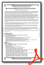
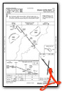
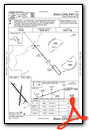
Instrument Approach Procedure (IAP) Charts
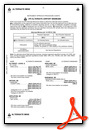
Nearby Airports with Instrument Procedures
| ID | Name | Heading / Distance | ||
|---|---|---|---|---|
 |
KPBH | Price County Airport | 062° | 28.2 |
|
Y23 | Chetek Municipal/Southworth Airport | 247° | 29.2 |
|
KRPD | Rice Lake Regional/Carl's Field Airport | 262° | 33.0 |
|
KPKF | Park Falls Municipal Airport | 041° | 36.6 |
|
KHYR | Sawyer County Airport | 329° | 36.8 |
|
KMDZ | Taylor County Airport | 128° | 38.0 |
|
KSSQ | Shell Lake Municipal Airport | 290° | 41.2 |
|
KUBE | Cumberland Municipal Airport | 271° | 41.4 |
|
KEAU | Chippewa Valley Regional Airport | 208° | 43.1 |
|
3CU | Cable Union Airport | 346° | 43.2 |
|
KTKV | Tomahawk Regional Airport | 091° | 50.5 |
|
3T3 | Boyceville Municipal Airport | 238° | 51.1 |
Airport Images
Do you have a recent image of this airport? Upload it here!


