Login
Register


RDD
Redding Regional Airport
Official FAA Data Effective 2024-04-18 0901Z
Chart Supplement

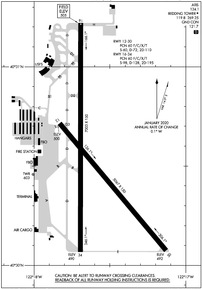
KRDD Airport Diagram
VFR Chart of KRDD
Sectional Charts at SkyVector.com
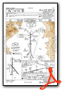
IFR Chart of KRDD
Enroute Charts at SkyVector.com
Location Information for KRDD
Coordinates: N40°30.54' / W122°17.60'Located 06 miles SE of Redding, California on 1584 acres of land. View all Airports in California.
Surveyed Elevation is 504 feet MSL.
Operations Data
|
|
Airport Communications
| ATIS: | 124.1 |
|---|---|
| ASOS: | Tel. 530-221-7144 |
| REDDING TOWER: | 119.8 269.25 |
| REDDING GROUND: | 121.7 |
| CTAF: | 119.800 |
| UNICOM: | 122.950 |
| AWOS-2 at O85 (6.6 NW): | 118.675 530-225-4183 |
| ASOS at RBL (21.5 S): | 120.775 530-528-8030 |
| AWOS-3 at O54 (32.0 NW): | 120.850 530-623-3810 |
- APCH/DEP CTL SVC PRVDD BY OAKLAND ARTCC (ZOA) ON FREQS 132.2/350.3 (RED BLUFF RCAG).
- EMERG FREQ 121.5 NOT AVBL.
Nearby Navigation Aids
|
| ||||||||||||||||||||||||||||||||||||


Runway 16/34
| Dimensions: | 7003 x 150 feet / 2135 x 46 meters | |
|---|---|---|
| Surface: | Asphalt / Grooved in Good Condition | |
| Weight Limits: | 60 /F/C/X/T, S-98, D-128, ST-195 | |
| Edge Lighting: | High Intensity | |
| Runway 16 | Runway 34 | |
| Coordinates: | N40°31.22' / W122°17.69' | N40°30.07' / W122°17.69' |
| Elevation: | 504.6 | 490.4 |
| Traffic Pattern: | Left | Left |
| Runway Heading: | 180° True | 0 |
| Declared Distances: | TORA:7003 TODA:7003 ASDA:7003 LDA:7003 | TORA:7003 TODA:7003 ASDA:7003 LDA:7003 |
| Markings: | Precision Instrument in good condition. | Precision Instrument in good condition. |
| Glide Slope Indicator | P4L (3.43° Glide Path Angle) | P4L (3.00° Glide Path Angle) |
| Approach Lights: | RLLS RLLS | MALSR 1,400 Foot Medium-intensity Approach Lighting System with runway alignment indicator lights. |
| REIL: | Yes | |
| Obstacles: | 44 ft Tree 1700 ft from runway, 650 ft right of center | |
Runway 12/30
| Dimensions: | 5067 x 150 feet / 1544 x 46 meters | |
|---|---|---|
| Surface: | Asphalt in Good Condition | |
| Weight Limits: | 60 /F/C/X/T, S-60, D-72, ST-110 | |
| Edge Lighting: | Medium Intensity | |
| Runway 12 | Runway 30 | |
| Coordinates: | N40°30.71' / W122°17.83' | N40°30.07' / W122°17.13' |
| Elevation: | 499.7 | 492.0 |
| Traffic Pattern: | Left | Left |
| Runway Heading: | 140° True | 320° True |
| Declared Distances: | TORA:5067 TODA:5067 ASDA:5067 LDA:5067 | TORA:5067 TODA:5067 ASDA:5067 LDA:5067 |
| Markings: | Basic in good condition. | Basic in good condition. |
| Glide Slope Indicator | P2L (3.00° Glide Path Angle) | |
| Obstacles: | 65 ft Trees 1600 ft from runway, 300 ft right of center | 88 ft Tree 2075 ft from runway, 275 ft right of center |
Services Available
| Fuel: | 100LL (blue), Jet-A |
|---|---|
| Transient Storage: | Tiedowns |
| Airframe Repair: | MAJOR |
| Engine Repair: | MAJOR |
| Bottled Oxygen: | HIGH/LOW |
| Bulk Oxygen: | HIGH/LOW |
| Other Services: | AIR AMBULANCE SERVICES,AVIONICS,CARGO HANDLING SERVICES,CHARTER SERVICE,PILOT INSTRUCTION,AIRCRAFT RENTAL,AIRCRAFT SALES |
Ownership Information
| Ownership: | Publicly owned | |
|---|---|---|
| Owner: | CITY OF REDDING | |
| AIRPORTS DIVISION, 6751 WOODRUM CIRCLE, #200 | ||
| REDDING, CA 96002-6071 | ||
| 530-224-4321 | ||
| Manager: | JAMES WADLEIGH | EMAIL: JWADLEIGH@CITYOFREDDING.ORG |
| 6751 WOODRUM, 6751 WOODRUM CIRCLE SUITE 200 | ||
| REDDING, CA 96002 | ||
| 530-224-4321 | ||
Operational Statistics
| Single Engine Aircraft Based on Field: | 175 | Statistics collected for 12 month period ending 2022-12-31 | |
|---|---|---|---|
| Multi-Engine Aircraft Based on Field: | 15 | Annual Commercial Operations: | 1880 |
| Jet Aircraft Based on Field: | 31 | Annual Commuter Operations: | none |
| Helicopters Based on Field: | 19 | Annual Air Taxi Operations: | 19859 |
| Military Aircraft Based on Field: | none | Annual Military Operations: | 853 |
| Gliders Based on Field: | none | Annual GA Local Operations: | 21052 |
| Ultralights Based on Field: | none | Annual GA Itinerant Operations: | 17258 |
Other Remarks
- U.S. FOREST SERVICE ON FLD, EXPECT HEAVY AIR TANKER ACTIVITY DURING FIRE SEASON.
- FIELD CONDITIONS RWY; APNS & TWYS GOOD TO FAIR.
- FOR NOISE ABATEMENT AVOID OVERFLIGHTS OF RESIDENTIAL HOUSING WHEN POSSIBLE.
- USE CTN BIRDS INVOF ARPT.
- FOR CD IF UNA TO CTC ON FSS FREQ, CTC OAKLAND ARTCC AT 510-745-3380.
- ACTVT MALSR RWY 34; REIL RWY 16; PAPI RWY 16; HIRL RWY 16/34; MIRL RWY 12/30; TWY LGTS - CTAF.
Weather Minimums
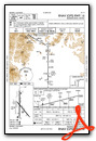
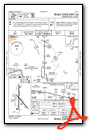
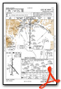
Instrument Approach Procedure (IAP) Charts
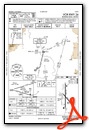
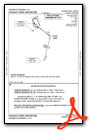
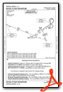
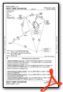
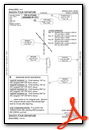
Departure Procedure (DP) Charts
Nearby Airports with Instrument Procedures
| ID | Name | Heading / Distance | ||
|---|---|---|---|---|
 |
O85 | Benton Field Airport | 306° | 6.5 |
|
KRBL | Red Bluff Municipal Airport | 174° | 21.6 |
|
KCIC | Chico Regional Airport | 154° | 47.2 |
|
O37 | Haigh Field Airport | 171° | 47.8 |
|
O46 | Weed Airport | 352° | 58.7 |
|
KWLW | Willows/Glenn County Airport | 176° | 59.7 |
|
KOVE | Oroville Municipal Airport | 152° | 68.6 |
|
KSVE | Susanville Municipal Airport | 095° | 79.2 |
|
O28 | Ells Field/Willits Municipal Airport | 218° | 80.6 |
|
O08 | Colusa County Airport | 170° | 80.9 |
|
KFOT | Rohnerville Airport | 272° | 84.2 |
|
KEKA | Murray Field Airport | 282° | 84.9 |
Airport Images

By: andys317


