Login
Register


RFD
Chicago/Rockford International Airport
Official FAA Data Effective 2024-04-18 0901Z
Chart Supplement

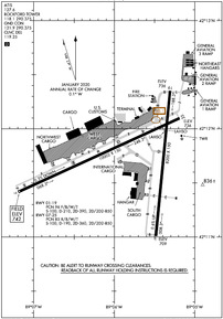
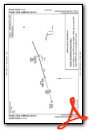
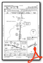
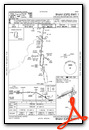
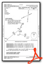
KRFD Airport Diagram
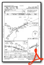
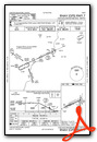
VFR Chart of KRFD
Sectional Charts at SkyVector.com
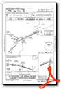
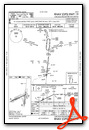
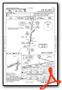
IFR Chart of KRFD
Enroute Charts at SkyVector.com
Location Information for KRFD
Coordinates: N42°11.72' / W89°5.83'Located 68 miles NW of Chicago/Rockford, Illinois on 2900 acres of land. View all Airports in Illinois.
Surveyed Elevation is 742 feet MSL.
Operations Data
|
|
Airport Communications
| ATIS: | 127.6 |
|---|---|
| ASOS: | Tel. 815-484-6223 |
| ROCKFORD TOWER: | 118.1 290.375 |
| ROCKFORD GROUND: | 121.9 290.375 |
| ROCKFORD APPROACH: | 121.0 ;EAST 126.0 ;WEST 327.0 |
| ROCKFORD DEPARTURE: | 121.0 ;EAST 126.0 ;WEST 327.0 |
| IC: | 121.0 ;EAST |
| CLEARANCE DELIVERY: | 119.25 |
| UNICOM: | 122.950 |
| EMERG: | 121.5 243.0 |
| TRSA: | 121.0 ;EAST 126.0 ;WEST 327.0 |
| AWOS-3 at RPJ (18.2 S): | 125.2 815-562-2955 |
| AWOS-3 at FEP (21.8 W): | 120.525 815-233-4472 |
| AWOS-3 at DKB (23.5 SE): | 119.075 815-748-2350 |
Nearby Navigation Aids
|
| ||||||||||||||||||||||||||||||||||||||||||||||||


Runway 07/25
| Dimensions: | 10002 x 150 feet / 3049 x 46 meters | |
|---|---|---|
| Surface: | Asphalt-Concrete / Grooved in Good Condition CONC PORTION GOOD CONDITION. | |
| Weight Limits: | 85 /R/B/W/T, S-100, D-190, ST-360, DT-850 | |
| Edge Lighting: | High Intensity | |
| Runway 07 | Runway 25 | |
| Coordinates: | N42°11.41' / W89°7.20' | N42°12.10' / W89°5.18' |
| Elevation: | 742.0 | 735.9 |
| Traffic Pattern: | Left | Left |
| Runway Heading: | 65° True | 245° True |
| Declared Distances: | TORA:10002 TODA:10002 ASDA:10002 LDA:10002 | TORA:10002 TODA:10002 ASDA:10002 LDA:10002 |
| Markings: | Precision Instrument in good condition. | Precision Instrument in good condition. |
| Glide Slope Indicator | P4R (3.00° Glide Path Angle) | P4L (3.00° Glide Path Angle) |
| RVR Equipment | Touchdown Midfield Rollout | Touchdown Midfield Rollout |
| Approach Lights: | ALSF2 Standard 2,400 Foot High-intensity Approach Lighting System with sequenced flashers, CATEGORY II or III Configuration. | |
| REIL: | Yes | |
| Centerline Lights: | Yes | Yes |
| Obstacles: | 128 ft Trees 4660 ft from runway, 1236 ft right of center | 51 ft Tree 1222 ft from runway, 420 ft left of center |
Runway 01/19
| Dimensions: | 8200 x 150 feet / 2499 x 46 meters | |
|---|---|---|
| Surface: | Asphalt-Concrete / Grooved in Good Condition | |
| Weight Limits: | 96 /F/B/W/T, S-100, D-210, ST-390, DT-850 | |
| Edge Lighting: | High Intensity | |
| Runway 01 | Runway 19 | |
| Coordinates: | N42°11.01' / W89°5.48' | N42°12.35' / W89°5.31' |
| Elevation: | 708.8 | 735.8 |
| Traffic Pattern: | Left | Left |
| Runway Heading: | 5° True | 185° True |
| Declared Distances: | TORA:8199 TODA:8199 ASDA:8199 LDA:8199 | TORA:8199 TODA:8199 ASDA:8099 LDA:8099 |
| Markings: | Precision Instrument in good condition. | Precision Instrument in good condition. |
| Glide Slope Indicator | P4L (3.00° Glide Path Angle) | |
| RVR Equipment | Touchdown | Rollout |
| Approach Lights: | MALSR 1,400 Foot Medium-intensity Approach Lighting System with runway alignment indicator lights. | |
| REIL: | Yes | |
| Centerline Lights: | Yes | Yes |
| Obstacles: | 7 ft Road 541 ft from runway, 542 ft right of center | 65 ft Tree 2613 ft from runway, 561 ft right of center |
Services Available
| Fuel: | 100LL (blue), Jet-A, Jet A-1+ |
|---|---|
| Transient Storage: | Hangars,Tiedowns |
| Airframe Repair: | MAJOR |
| Engine Repair: | MAJOR |
| Bottled Oxygen: | HIGH |
| Bulk Oxygen: | HIGH |
| Other Services: | CARGO HANDLING SERVICES,CHARTER SERVICE,PILOT INSTRUCTION,AIRCRAFT RENTAL |
Ownership Information
| Ownership: | Publicly owned | |
|---|---|---|
| Owner: | GREATER ROCKFORD ARPT. AUTH. | |
| 60 ARPT DRIVE | ||
| ROCKFORD, IL 61109-2902 | ||
| 815-969-4011 | ||
| Manager: | ZACHARY OAKLEY | |
| 60 AIRPORT DR | ||
| ROCKFORD, IL 61109-2902 | ||
| 815-965-4011 | ||
Operational Statistics
| Single Engine Aircraft Based on Field: | 78 | Statistics collected for 12 month period ending 2023-12-31 | |
|---|---|---|---|
| Multi-Engine Aircraft Based on Field: | 18 | Annual Commercial Operations: | 21845 |
| Jet Aircraft Based on Field: | 15 | Annual Commuter Operations: | none |
| Helicopters Based on Field: | 3 | Annual Air Taxi Operations: | 1370 |
| Military Aircraft Based on Field: | none | Annual Military Operations: | 328 |
| Gliders Based on Field: | none | Annual GA Local Operations: | 8105 |
| Ultralights Based on Field: | none | Annual GA Itinerant Operations: | 12964 |
Other Remarks
- ARFF INDEX E EQUIP AVBL WITH 1 HR PPR CALL 815-969-4011
- BIRDS & DEER ON & INVOF ARPT.
- TRIPLE-TANDEM TRT550 RY 07/25 & TRT590 RY 01/19.
- US CUSTOMS OFFICE RQR 2 HR ADVANCE NOTICE DURING BUSINESS HRS MON-FRI 0830-1700.
Weather Minimums
Standard Terminal Arrival (STAR) Charts
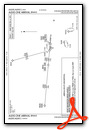
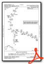
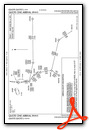
Instrument Approach Procedure (IAP) Charts
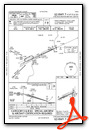
Departure Procedure (DP) Charts
Nearby Airports with Instrument Procedures
| ID | Name | Heading / Distance | ||
|---|---|---|---|---|
 |
C77 | Poplar Grove Airport | 056° | 13.9 |
|
KRPJ | Rochelle Municipal/Koritz Field Airport | 177° | 18.2 |
|
44C | Beloit Airport | 017° | 19.0 |
|
KFEP | Albertus Airport | 278° | 21.8 |
|
KDKB | De Kalb Taylor Municipal Airport | 131° | 23.5 |
|
KJVL | Southern Wisconsin Regional Airport | 005° | 25.6 |
|
C73 | Dixon Municipal-Charles R Walgreen Field Airport | 215° | 26.7 |
|
KEFT | Monroe Municipal Airport | 319° | 33.4 |
|
10C | Galt Field Airport | 068° | 34.5 |
|
3CK | Lake In The Hills Airport | 088° | 34.5 |
|
KSQI | Whiteside County/Jos H Bittorf Field Airport | 223° | 37.5 |
|
KARR | Aurora Municipal Airport | 132° | 37.7 |
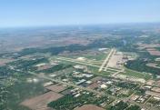
Airport Images

By: 2flaps
By: james_sm


