Login
Register


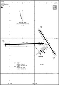
RHI
Rhinelander/Oneida County Airport
Official FAA Data Effective 2024-04-18 0901Z
Chart Supplement

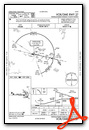
KRHI Airport Diagram
VFR Chart of KRHI
Sectional Charts at SkyVector.com
IFR Chart of KRHI
Enroute Charts at SkyVector.com
Location Information for KRHI
Coordinates: N45°37.85' / W89°28.00'Located 02 miles SW of Rhinelander, Wisconsin on 1259 acres of land. View all Airports in Wisconsin.
Surveyed Elevation is 1623 feet MSL.
Operations Data
|
|
Airport Communications
| ASOS: | 126.825 Tel. 715-362-7980 |
|---|---|
| UNICOM: | 123.000 |
| CTAF: | 123.000 |
| AWOS-3 at TKV (17.2 SW): | 118.250 715-453-5716 |
| AWOS-3 at EGV (19.9 NE): | 118.325 715-479-1465 |
| AWOS-3 at ARV (21.0 NW): | 121.125 715-356-2417 |
- APCH/DEP SVC PRVDD BY MINNEAPOLIS ARTCC ON FREQS 133.65/281.5 (RHINELANDER RCAG).
Nearby Navigation Aids
|
| ||||||||||||||||||||||||||||||||||||||||||||||||


Runway 09/27
| Dimensions: | 6800 x 150 feet / 2073 x 46 meters | |
|---|---|---|
| Surface: | Concrete / Grooved in Good Condition | |
| Weight Limits: | 34 /R/C/W/T, S-95, D-150, ST-235 | |
| Edge Lighting: | High Intensity | |
| Runway 09 | Runway 27 | |
| Coordinates: | N45°37.82' / W89°29.20' | N45°37.85' / W89°27.60' |
| Elevation: | 1623.3 | 1599.2 |
| Traffic Pattern: | Left | Left |
| Runway Heading: | 88° True | 268° True |
| Declared Distances: | TORA:6799 TODA:6799 ASDA:6799 LDA:6799 | TORA:6799 TODA:6799 ASDA:6799 LDA:6799 |
| Markings: | Precision Instrument in good condition. | Precision Instrument in good condition. |
| Glide Slope Indicator | P4L (3.00° Glide Path Angle) | P4L (3.00° Glide Path Angle) |
| Approach Lights: | MALSR 1,400 Foot Medium-intensity Approach Lighting System with runway alignment indicator lights. | |
| REIL: | Yes | |
Runway 15/33
| Dimensions: | 5201 x 100 feet / 1585 x 30 meters | |
|---|---|---|
| Surface: | Asphalt in Fair Condition | |
| Weight Limits: | 24 /F/A/X/T, S-55, D-95, ST-160 | |
| Edge Lighting: | High Intensity | |
| Runway 15 | Runway 33 | |
| Coordinates: | N45°38.24' / W89°27.80' | N45°37.52' / W89°27.14' |
| Elevation: | 1597.4 | 1611.2 |
| Traffic Pattern: | Left | Left |
| Runway Heading: | 147° True | 327° True |
| Declared Distances: | TORA:5201 TODA:5201 ASDA:5201 LDA:5201 | TORA:5201 TODA:5201 ASDA:5201 LDA:5201 |
| Markings: | Non-Precision Instrument in good condition. | Non-Precision Instrument in good condition. |
| Glide Slope Indicator | V4L (3.75° Glide Path Angle) | P4L (3.00° Glide Path Angle) |
| REIL: | Yes | Yes |
| Obstacles: | 75 ft Tree 1740 ft from runway, 200 ft right of center | 30 ft Tree 1145 ft from runway, 160 ft left of center |
Services Available
| Fuel: | 100LL (blue), Jet-A |
|---|---|
| Transient Storage: | Hangars,Tiedowns |
| Airframe Repair: | MAJOR |
| Engine Repair: | MAJOR |
| Bottled Oxygen: | NONE |
| Bulk Oxygen: | NONE |
| Other Services: | AIR FREIGHT SERVICES,AIR AMBULANCE SERVICES,CHARTER SERVICE,PILOT INSTRUCTION,AIRCRAFT RENTAL,AIRCRAFT SALES |
Ownership Information
| Ownership: | Publicly owned | |
|---|---|---|
| Owner: | RHINELANDER & ONEIDA CO. | |
| 3375 AIRPORT ROAD | ||
| RHINELANDER, WI 54501 | ||
| 715-365-3416 | ||
| Manager: | MATTHEW LEITNER | |
| 3375 AIRPORT RD | ||
| RHINELANDER, WI 54501 | ||
| 715-365-3418 | ||
Operational Statistics
| Single Engine Aircraft Based on Field: | 37 | Statistics collected for 12 month period ending 2022-12-31 | |
|---|---|---|---|
| Multi-Engine Aircraft Based on Field: | 3 | Annual Commercial Operations: | 1558 |
| Jet Aircraft Based on Field: | 2 | Annual Commuter Operations: | none |
| Helicopters Based on Field: | 1 | Annual Air Taxi Operations: | 1400 |
| Military Aircraft Based on Field: | none | Annual Military Operations: | none |
| Gliders Based on Field: | none | Annual GA Local Operations: | 12000 |
| Ultralights Based on Field: | none | Annual GA Itinerant Operations: | 10000 |
Other Remarks
- BIRDS & COYOTE ON & INVOF ARPT.
- FOR CD IF UNA TO CTC ON FSS FREQ, CTC MINNEAPOLIS ARTCC AT 651-463-5588.
- SFC CONDS NOT MONTRD BTWN 0000 - 0500 HRS.
- 24HR SELF SVC FUEL AVAIL 100 LL & JET A.
- ACTIVATE MALSR RWY 09; REIL RWY 15, 27 & 33; PAPI RWY 09, 27 & 33; HIRL RWY 09/27 & 15/33 - CTAF. VASI RWY 15 OPR CONSLY. HIRL RWY 9/27 PRESET LOW INTENSITY; TO INCREASE INTENSITY - CTAF.
Weather Minimums
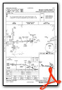
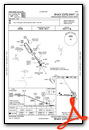
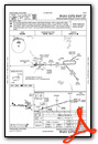
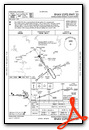
Instrument Approach Procedure (IAP) Charts
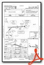
Nearby Airports with Instrument Procedures
| ID | Name | Heading / Distance | ||
|---|---|---|---|---|
 |
KTKV | Tomahawk Regional Airport | 235° | 17.2 |
|
KEGV | Eagle River Union Airport | 024° | 19.9 |
|
KARV | Lakeland/Noble F Lee Memorial Field Airport | 328° | 21.0 |
|
Y55 | Crandon/Steve Conway Municipal Airport | 105° | 23.6 |
|
KRRL | Merrill Municipal Airport | 201° | 27.9 |
|
KAIG | Langlade County Airport | 152° | 32.3 |
|
KLNL | Kings Land O' Lakes Airport | 018° | 33.2 |
|
D25 | Manitowish Waters Airport | 329° | 34.1 |
|
KPBH | Price County Airport | 277° | 39.7 |
|
KAUW | Wausau Downtown Airport | 189° | 42.8 |
|
KPKF | Park Falls Municipal Airport | 296° | 44.7 |
|
KMDZ | Taylor County Airport | 228° | 47.5 |
Airport Images
Do you have a recent image of this airport? Upload it here!


