Login
Register


RME
Griffiss International Airport
Official FAA Data Effective 2024-04-18 0901Z
Chart Supplement

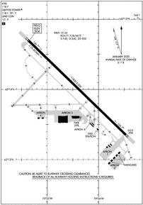
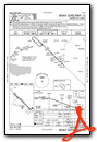
KRME Airport Diagram
VFR Chart of KRME
Sectional Charts at SkyVector.com
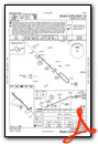
IFR Chart of KRME
Enroute Charts at SkyVector.com
Location Information for KRME
Coordinates: N43°14.03' / W75°24.42'Located 01 miles NE of Rome, New York on 1680 acres of land. View all Airports in New York.
Surveyed Elevation is 504 feet MSL.
Operations Data
|
|
Airport Communications
| ATIS: | 118.7 |
|---|---|
| ASOS: | Tel. 315-337-0379 |
| GRIFFISS TOWER: | 118.1 291.7 |
| GRIFFISS GROUND: | 121.9 |
| SYRACUSE APPROACH: | 127.425 290.45 |
| SYRACUSE DEPARTURE: | 395.0 ;329-157 127.425 290.45 |
| EMERG: | 121.5 243.0 |
| CTAF: | 118.100 |
| UNICOM: | 122.950 |
| AWOS-3P at VGC (24.4 S): | 119.425 315-824-1825 |
| ASOS at SYR (31.5 W): | 315-454-3350 |
| ATIS at SYR (31.5 W): | 124.225 |
Nearby Navigation Aids
|
| ||||||||||||||||||||||||||||||||||||||||||||||||||||||||||||


Runway 15/33
| Dimensions: | 11820 x 200 feet / 3603 x 61 meters | |
|---|---|---|
| Surface: | Asphalt / Grooved in Good Condition | |
| Weight Limits: | 71 /F/B/W/T, S-100, D-240, ST-500 | |
| Edge Lighting: | High Intensity | |
| Runway 15 | Runway 33 | |
| Coordinates: | N43°14.70' / W75°25.38' | N43°13.35' / W75°23.47' |
| Elevation: | 504.0 | 498.0 |
| Traffic Pattern: | Left | Right |
| Runway Heading: | 134° True | 314° True |
| Declared Distances: | TORA:11820 TODA:11820 ASDA:11820 LDA:11820 | TORA:11820 TODA:11820 ASDA:11820 LDA:11820 |
| Markings: | Non-Standard in good condition. | Non-Standard in good condition. |
| Glide Slope Indicator | P4L (3.00° Glide Path Angle) | P4L (3.00° Glide Path Angle) |
| Approach Lights: | MALSR 1,400 Foot Medium-intensity Approach Lighting System with runway alignment indicator lights. | |
Services Available
| Fuel: | 100LL (blue), Jet-A |
|---|---|
| Transient Storage: | Hangars,Tiedowns |
| Airframe Repair: | MAJOR |
| Engine Repair: | MAJOR |
| Bottled Oxygen: | NONE |
| Bulk Oxygen: | NOT AVAILABLE |
| Other Services: | AIR FREIGHT SERVICES,CHARTER SERVICE,PILOT INSTRUCTION |
Ownership Information
| Ownership: | Publicly owned | |
|---|---|---|
| Owner: | COUNTY OF ONEIDA | |
| ONEIDA COUNTY OFFICE BLDG, 800 PARK AVE | ||
| UTICA, NY 13501 | ||
| 315-798-5800 | ||
| Manager: | EDWARD ARCURI | |
| 660 HANGAR RD SUITE 223 | ||
| ROME, NY 13441-4522 | ||
| 315-736-4171 | ||
Operational Statistics
| Single Engine Aircraft Based on Field: | 42 | Statistics collected for 12 month period ending 2023-07-31 | |
|---|---|---|---|
| Multi-Engine Aircraft Based on Field: | 4 | Annual Commercial Operations: | 10 |
| Jet Aircraft Based on Field: | 7 | Annual Commuter Operations: | none |
| Helicopters Based on Field: | 11 | Annual Air Taxi Operations: | 1046 |
| Military Aircraft Based on Field: | none | Annual Military Operations: | 3794 |
| Gliders Based on Field: | 1 | Annual GA Local Operations: | 17385 |
| Ultralights Based on Field: | none | Annual GA Itinerant Operations: | 10645 |
Other Remarks
- PPR 24 HRS FOR AIR CARRIER OPS WITH MORE THAN 30 PASSENGER SEATS CALL ARPT MANAGER 315-790-3072 OR 315-272-5881.
- PPR 24 HRS FOR AIR CARRIER OPS WITH MORE THAN 9 PASSENGER SEATS OUTSIDE OF ATTENDACE SCHEDULE HRS CALL ARPT MANAGER 315-790-3072 OR 315-272-5881.
- WHEN ATCT CLSD, FOR CD CTC SYRACUSE APCH AT 315-455-6218
- ARFF NOT PRVDD FROM 2300-0700 WO PPR.
- MIGRATORY BIRD ALERT: AUG-NOV AND APR-MAY.
- PTNS OF APN NOT VSB FROM ATCT.
- RWY 33 DSGND CALM WIND RWY.
- MIL ASSAULT LZ & PIR MARKINGS.
- MIL ASSAULT LZ & PIR MARKINGS.
- WHEN ATCT CLSD ACTVT MALSR RWY 33; HIRL RWY 15/33; TWY LGTS - CTAF.
Weather Minimums
Instrument Approach Procedure (IAP) Charts
Nearby Airports with Instrument Procedures
| ID | Name | Heading / Distance | ||
|---|---|---|---|---|
 |
KVGC | Hamilton Municipal Airport | 196° | 24.4 |
|
KSYR | Syracuse Hancock International Airport | 256° | 31.6 |
|
KOIC | Lt Warren Eaton Airport | 187° | 40.4 |
|
K09 | Piseco Airport | 071° | 41.2 |
|
KFZY | Oswego County Airport | 279° | 43.6 |
|
N66 | Albert S Nader Regional Airport | 160° | 45.1 |
|
6B9 | Skaneateles Aero Drome Airport | 247° | 49.3 |
|
NY0 | Fulton County Airport | 106° | 49.4 |
|
B16 | Whitfords Airport | 259° | 50.5 |
|
KGTB | Wheeler-Sack AAF Airport | 344° | 51.2 |
|
N03 | Cortland County/Chase Field Airport | 223° | 52.4 |
|
KART | Watertown International Airport | 329° | 52.7 |
Airport Images

By: youngchoe

By: ronnatphi


