Login
Register


RMN
Stafford Regional Airport
Official FAA Data Effective 2024-04-18 0901Z
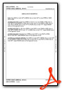
Chart Supplement

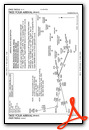
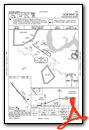
VFR Chart of KRMN
Sectional Charts at SkyVector.com
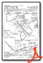
IFR Chart of KRMN
Enroute Charts at SkyVector.com
Location Information for KRMN
Coordinates: N38°23.89' / W77°27.33'Located 03 miles SW of Stafford, Virginia on 566 acres of land. View all Airports in Virginia.
Surveyed Elevation is 211 feet MSL.
Operations Data
|
|
Airport Communications
| AWOS-3: | 126.325 Tel. 540-657-8283 |
|---|---|
| QUANTICO APPROACH: | 128.525 ;WHEN NYG TWR CLSD 306.925 ;WHEN NYG TWR CLSD 127.05 290.375 |
| QUANTICO DEPARTURE: | 128.525 ;WHEN NYG TWR CLSD 306.925 ;WHEN NYG TWR CLSD 127.05 290.375 |
| CTAF: | 122.725 |
| HYPER STAR: | 133.0 288.35 |
| TIKEE STAR: | 120.45 306.925 |
| TRSTN STAR: | 126.75 307.2 |
| UNICOM: | 122.725 |
| AWOS-3 at EZF (7.9 S): | 128.125 540-372-6794 |
| ATIS at NYG (9.5 NE): | 263.15 |
| AWOS-3 at HWY (16.7 NW): | 120.350 540-788-4078 |
- APCH/DEP SVC PRVDD BY POTOMAC TRACON (PCT) ON 128.525/ 306.925 WHEN QUANTICO (NYG) CLSD.
Nearby Navigation Aids
|
| ||||||||||||||||||||||||||||||||||||||||||||||||||||||||||||


Runway 15/33
| Dimensions: | 5000 x 100 feet / 1524 x 30 meters | |
|---|---|---|
| Surface: | Asphalt / Grooved in Good Condition | |
| Weight Limits: | S-30, D-70 | |
| Edge Lighting: | High Intensity | |
| Runway 15 | Runway 33 | |
| Coordinates: | N38°24.20' / W77°27.67' | N38°23.57' / W77°26.99' |
| Elevation: | 211.2 | 171.2 |
| Traffic Pattern: | Left | |
| Runway Heading: | 139° True | 319° True |
| Markings: | Non-Precision Instrument in good condition. | Precision Instrument in good condition. |
| Glide Slope Indicator | P4L (3.00° Glide Path Angle) | P4L (3.00° Glide Path Angle) |
| Approach Lights: | MALS 1,400 Foot Medium-intensity Approach Lighting System. | |
| REIL: | Yes | |
| Obstacles: | 28 ft Trees 1227 ft from runway, 10 ft right of center | 36 ft Trees 441 ft from runway, 503 ft right of center |
Services Available
| Fuel: | 100LL (blue), Jet-A |
|---|---|
| Transient Storage: | Tiedowns |
| Airframe Repair: | MINOR |
| Engine Repair: | MINOR |
| Bottled Oxygen: | LOW |
| Bulk Oxygen: | NOT AVAILABLE |
| Other Services: | PILOT INSTRUCTION |
Ownership Information
| Ownership: | Publicly owned | |
|---|---|---|
| Owner: | STATE | |
| 95 AVIATION WAY | ||
| FREDERICKSBURG, VA 22406 | ||
| 540-658-1212 | ||
| Manager: | JAMES STOVER | |
| 95 AVIATION WAY | ||
| FREDERICKSBURG, VA 22406 | ||
| 540-658-1212 | ||
Operational Statistics
| Single Engine Aircraft Based on Field: | 77 | Statistics collected for 12 month period ending 2018-12-31 | |
|---|---|---|---|
| Multi-Engine Aircraft Based on Field: | 5 | Annual Commercial Operations: | none |
| Jet Aircraft Based on Field: | none | Annual Commuter Operations: | none |
| Helicopters Based on Field: | 6 | Annual Air Taxi Operations: | none |
| Military Aircraft Based on Field: | none | Annual Military Operations: | 1965 |
| Gliders Based on Field: | none | Annual GA Local Operations: | 7863 |
| Ultralights Based on Field: | none | Annual GA Itinerant Operations: | 20313 |
Other Remarks
- DEER & FLOCKS OF BIRDS ON & INVOF ARPT.
- GCO AVBL ON FREQ 135.075 SERVICED BY QUANTICO AND POTOMAC APP. IF UNA, FOR CD CTC POTOMAC APCH AT 866-709-4993.
- NOISE: IN EFF 24 HRS. VFR ACFT DEPARTING RWY 33 FLY RWY HEADING UNTIL BASEBALL FIELDS 1 NM THEN TURN LEFT.
- 0LL FUEL AVBL UNTIL 1800; AFTER HRS CALL 540-288-3838 WITHIN 12 HRS NOTICE. PRIST AVBL.
- GOVT CONTR FUEL.
- ACTVT MALS RWY 33; REIL RWY 15; HIRL RWY 15/33 - CTAF.
Weather Minimums
Standard Terminal Arrival (STAR) Charts
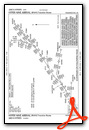
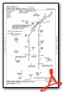
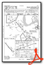
Instrument Approach Procedure (IAP) Charts
Nearby Airports with Instrument Procedures
| ID | Name | Heading / Distance | ||
|---|---|---|---|---|
 |
KEZF | Shannon Airport | 177° | 7.9 |
|
KNYG | Quantico Mcaf (Turner Field) Airport | 048° | 9.5 |
|
KHWY | Warrenton/Fauquier Airport | 313° | 16.5 |
|
KHEF | Manassas Regional/Harry P Davis Field Airport | 351° | 19.6 |
|
KCJR | Culpeper Regional Airport | 291° | 20.5 |
|
2W5 | Maryland Airport | 056° | 21.6 |
|
KDAA | Davison AAF Airport | 034° | 23.0 |
|
KOMH | Orange County Airport | 252° | 29.3 |
|
7W4 | Lake Anna Airport | 208° | 29.3 |
|
KVKX | Potomac Airfield Airport | 048° | 31.5 |
|
KIAD | Washington Dulles International Airport | 359° | 32.9 |
|
KDCA | Ronald Reagan Washington Ntl Airport | 035° | 33.5 |
Airport Images
Do you have a recent image of this airport? Upload it here!


