Login
Register


SBS
Steamboat Springs/Bob Adams Field Airport
Official FAA Data Effective 2024-04-18 0901Z
Chart Supplement

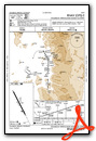
VFR Chart of KSBS
Sectional Charts at SkyVector.com
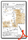
IFR Chart of KSBS
Enroute Charts at SkyVector.com
Location Information for KSBS
Coordinates: N40°30.98' / W106°51.98'Located 03 miles NW of Steamboat Springs, Colorado on 436 acres of land. View all Airports in Colorado.
Surveyed Elevation is 6882 feet MSL.
Operations Data
|
|
Airport Communications
| AWOS-3: | 118.325 Tel. 970-879-7794 |
|---|---|
| CTAF: | 122.800 |
| UNICOM: | 122.800 |
| AWOS-3PT at C07 (12.4 SE): | 127.125 970-824-0261 |
| AWOS-3PT at HDN (16.2 W): | 119.275 970-276-3690 |
| ASOS at CAG (29.9 W): | 135.425 970-824-2373 |
- APCH/DEP CTL SVC PRVDD BY DENVER ARTCC (ZDV) FREQS 120.475/235.975 (HAYDEN RCAG).
- COMMUNICATIONS PRVDD BY DENVER RADIO ON FREQ 122.2 (STEAMBOAT SPRINGS RCO).
Nearby Navigation Aids
|
| ||||||||||||||||||||||||||||||||||||||||||


Runway 14/32
| Dimensions: | 4452 x 100 feet / 1357 x 30 meters | |
|---|---|---|
| Surface: | Asphalt / Grooved in Good Condition | |
| Weight Limits: | S-50, D-60 | |
| Edge Lighting: | High Intensity | |
| Runway 14 | Runway 32 | |
| Coordinates: | N40°31.30' / W106°52.20' | N40°30.65' / W106°51.76' |
| Elevation: | 6874.7 | 6882.1 |
| Traffic Pattern: | Right | Left |
| Runway Heading: | 153° True | 333° True |
| Displaced Threshold: | 600 Feet | |
| Declared Distances: | TORA:4452 TODA:4452 ASDA:3852 LDA:3852 | TORA:4452 TODA:4452 ASDA:4452 LDA:3852 |
| Markings: | Basic in fair condition. | Non-Precision Instrument in fair condition. |
| Glide Slope Indicator | P2L (4.00° Glide Path Angle) PAPI BAFFLED; VIS LMTD TO 5.5 DEGS LEFT OF CNTRLN DUE TO HIGH TRRN. | |
| REIL: | Yes | |
Services Available
| Fuel: | 100LL (blue), Jet-A |
|---|---|
| Transient Storage: | Hangars,Tiedowns |
| Airframe Repair: | MINOR |
| Engine Repair: | MINOR |
| Bottled Oxygen: | HIGH/LOW |
| Bulk Oxygen: | HIGH/LOW |
| Other Services: | AIR AMBULANCE SERVICES,CHARTER SERVICE,PILOT INSTRUCTION |
Ownership Information
| Ownership: | Publicly owned | |
|---|---|---|
| Owner: | CITY OF STEAMBOAT SPRINGS | |
| PO BOX 775088 | ||
| STEAMBOAT SPRINGS, CO 80477 | ||
| 970-879-1204 | ||
| Manager: | STACIE FAIN | |
| PO BOX 775088 | ||
| STEAMBOAT SPRINGS, CO 80477 | ||
| 970-879-1204 | ||
Operational Statistics
| Single Engine Aircraft Based on Field: | 55 | Statistics collected for 12 month period ending 2018-12-31 | |
|---|---|---|---|
| Multi-Engine Aircraft Based on Field: | 3 | Annual Commercial Operations: | none |
| Jet Aircraft Based on Field: | 1 | Annual Commuter Operations: | none |
| Helicopters Based on Field: | 1 | Annual Air Taxi Operations: | 551 |
| Military Aircraft Based on Field: | none | Annual Military Operations: | 10 |
| Gliders Based on Field: | 1 | Annual GA Local Operations: | 9671 |
| Ultralights Based on Field: | 1 | Annual GA Itinerant Operations: | 1768 |
Other Remarks
- WILDLIFE ON & INVOF ARPT.
- COLD TEMPERATURE AIRPORT. ALTITUDE CORRECTION REQUIRED AT OR BELOW -26C.
- FOR CD IF UNA TO CTC ON FSS FREQ, CTC DENVER ARTCC AT 303-651-4257.
- SI NA TO AVOID TFC CONFLICTS.
- PREFERRED RWY; 180 FT DROPOFF 2000 FT FM PAVEMENT END.
- ACTVT REIL RWY 32; PAPI RWY 32; HIRL RWY 14/32 - CTAF.
- UNICOM AVBL 0700-1700.
Weather Minimums

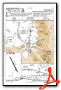
Instrument Approach Procedure (IAP) Charts
Nearby Airports with Instrument Procedures
| ID | Name | Heading / Distance | ||
|---|---|---|---|---|
 |
KHDN | Yampa Valley Airport | 262° | 16.2 |
|
KCAG | Craig-Moffat Airport | 267° | 30.0 |
|
33V | Walden-Jackson County Airport | 062° | 30.6 |
|
20V | Mc Elroy Airfield Airport | 140° | 35.9 |
|
KDWX | Dixon Airport | 317° | 42.3 |
|
KGNB | Granby-Grand County Airport | 120° | 50.5 |
|
KEGE | Eagle County Regional Airport | 182° | 52.4 |
|
KEEO | Meeker Coulter Field Airport | 239° | 54.6 |
|
KSAA | Shively Field Airport | 001° | 55.6 |
|
KRIL | Rifle Garfield County Airport | 214° | 71.4 |
|
KLAR | Laramie Regional Airport | 048° | 72.2 |
|
KASE | Aspen-Pitkin County/Sardy Field Airport | 180° | 77.6 |
Airport Images
Do you have a recent image of this airport? Upload it here!


