Login
Register


SIF
Rockingham County Nc Shiloh Airport
Official FAA Data Effective 2024-04-18 0901Z
Chart Supplement

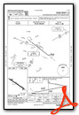
VFR Chart of KSIF
Sectional Charts at SkyVector.com
IFR Chart of KSIF
Enroute Charts at SkyVector.com
Location Information for KSIF
Coordinates: N36°26.23' / W79°51.06'Located 08 miles NW of Reidsville, North Carolina on 220 acres of land. View all Airports in North Carolina.
Surveyed Elevation is 693 feet MSL.
Operations Data
|
|
Airport Communications
| AWOS-3: | 119.775 Tel. 336-573-3677 |
|---|---|
| GREENSBORO APPROACH: | 124.35 269.225 |
| GREENSBORO DEPARTURE: | 124.35 269.225 |
| CTAF: | 122.800 |
| UNICOM: | 122.800 |
| AWOS-3 at MTV (14.1 NW): | 118.45 276-957-3784 |
| D-ATIS at GSO (20.6 S): | 128.55 |
| ASOS at GSO (20.9 S): | 128.55 336-393-0168 |
Nearby Navigation Aids
|
| ||||||||||||||||||||||||||||||||||||||||||||||||||||||||||||


Runway 13/31
| Dimensions: | 5200 x 100 feet / 1585 x 30 meters | |
|---|---|---|
| Surface: | Asphalt in Good Condition | |
| Weight Limits: | S-32, D-43 | |
| Edge Lighting: | High Intensity | |
| Runway 13 | Runway 31 | |
| Coordinates: | N36°26.48' / W79°51.50' | N36°25.99' / W79°50.62' |
| Elevation: | 693.5 | 667.9 |
| Traffic Pattern: | Left | Left |
| Runway Heading: | 125° True | 305° True |
| Displaced Threshold: | 500 Feet | |
| Markings: | Non-Precision Instrument in good condition. | Non-Precision Instrument in good condition. |
| Glide Slope Indicator | P4L (3.70° Glide Path Angle) | P4L (3.70° Glide Path Angle) |
| REIL: | Yes | Yes |
| Obstacles: | 83 ft Trees 671 ft from runway, 320 ft right of center APCH RATIO 10:1 AT DSPLCD THR; DUE TO 89 FT TREES 1156 FT FROM DSPLCD THR 318 FT RIGHT OF CNTRLN. 5 FT GND 0-200 FT FROM THR 150 FT RIGHT OF CNTRLN. |
55 ft Trees 893 ft from runway, 211 ft right of center |
Services Available
| Fuel: | 100LL (blue), Jet A-1+ |
|---|---|
| Transient Storage: | Tiedowns |
| Airframe Repair: | MAJOR |
| Engine Repair: | MAJOR |
| Bottled Oxygen: | NONE |
| Bulk Oxygen: | NONE |
| Other Services: | PILOT INSTRUCTION |
Ownership Information
| Ownership: | Publicly owned | |
|---|---|---|
| Owner: | ROCKINGHAM COUNTY | |
| 2691 SETTLE BRIDGE ROAD | ||
| STONEVILLE, NC 27048 | ||
| 336-573-3115 | ||
| Manager: | MIKE BROOKS | MANAGER CELL 336-613-7671. |
| 2691 SETTLE BRIDGE ROAD | ||
| STONEVILLE, NC 27048 | ||
| 336-573-3115 | FAX 336-573-9415. | |
Operational Statistics
| Single Engine Aircraft Based on Field: | 42 | Statistics collected for 12 month period ending 2022-11-04 | |
|---|---|---|---|
| Multi-Engine Aircraft Based on Field: | 4 | Annual Commercial Operations: | none |
| Jet Aircraft Based on Field: | 1 | Annual Commuter Operations: | none |
| Helicopters Based on Field: | 1 | Annual Air Taxi Operations: | none |
| Military Aircraft Based on Field: | none | Annual Military Operations: | 100 |
| Gliders Based on Field: | none | Annual GA Local Operations: | 15000 |
| Ultralights Based on Field: | none | Annual GA Itinerant Operations: | 9000 |
Other Remarks
- DEER ON & INVOF ARPT.
- FOR CD CTC GREENSBORO APCH AT 743-222-6129.
- SEASONAL FARMING OPNS AND EQPT INVOF RWY.
- 0LL 100LL FUEL 24 HR CREDIT CARD SVC AVBL.
- ACTVT REIL RWY 13 & 31; PAPI RWY 13 & 31; HIRL RWY 13/31 - CTAF.
Weather Minimums

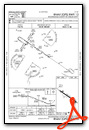
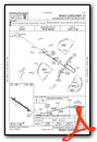
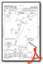
Instrument Approach Procedure (IAP) Charts
Nearby Airports with Instrument Procedures
| ID | Name | Heading / Distance | ||
|---|---|---|---|---|
 |
KMTV | Blue Ridge Airport | 325° | 14.1 |
|
N63 | Meadow Brook Field Airport | 240° | 16.5 |
|
KGSO | Piedmont Triad International Airport | 192° | 20.6 |
|
KINT | Smith Reynolds Airport | 224° | 25.6 |
|
KDAN | Danville Regional Airport | 071° | 26.2 |
|
KBUY | Burlington/Alamance Regional Airport | 141° | 29.6 |
|
KMWK | Mount Airy/Surry County Airport | 272° | 34.0 |
|
W91 | Smith Mountain Lake Airport | 017° | 42.1 |
|
KTDF | Raleigh Regional At Person County Airport | 102° | 43.0 |
|
8A7 | Twin Lakes Airport | 223° | 43.0 |
|
KEXX | Davidson County Exec Airport | 209° | 45.1 |
|
KZEF | Elkin Municipal Airport | 258° | 46.3 |
Airport Images
Do you have a recent image of this airport? Upload it here!


