Login
Register


SIY
Siskiyou County Airport
Official FAA Data Effective 2024-04-18 0901Z
Chart Supplement

VFR Chart of KSIY
Sectional Charts at SkyVector.com
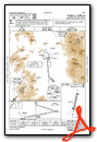
IFR Chart of KSIY
Enroute Charts at SkyVector.com
Location Information for KSIY
Coordinates: N41°46.89' / W122°28.09'Located 03 miles NE of Montague, California on 1080 acres of land. View all Airports in California.
Surveyed Elevation is 2651 feet MSL.
Operations Data
|
|
Airport Communications
| ASOS: | 121.125 Tel. 530-459-0267 |
|---|---|
| CTAF: | 123.000 |
| UNICOM: | 123.000 |
| ASOS at MHS (28.7 S): | 120.775 530-926-1613 |
| ASOS at LMT (39.8 NE): | 541-883-8127 |
| ATIS at LMT (39.8 NE): | 263.0 |
- APCH/DEP CTL SVC PRVDD BY SEATTLE ARTCC (ZSE) ON FREQS 124.85/306.3 (ANTELOPE MOUNTAIN RCAG).
- COMMUNICATIONS PRVDD BY RANCHO MURIETA RADIO ON FREQ 122.4 (ANTELOPE MTN RCO).
Nearby Navigation Aids
|
| ||||||||||||||||||||||||||||||||||||||||||


Runway 17/35
| Dimensions: | 7490 x 150 feet / 2283 x 46 meters | |
|---|---|---|
| Surface: | Asphalt in Good Condition | |
| Weight Limits: | S-60, D-180, ST-270 | |
| Edge Lighting: | Medium Intensity | |
| Runway 17 | Runway 35 | |
| Coordinates: | N41°47.49' / W122°27.93' | N41°46.28' / W122°28.24' |
| Elevation: | 2651.0 | 2631.5 |
| Traffic Pattern: | Left | Right |
| Runway Heading: | 191° True | 11° True |
| Markings: | Non-Precision Instrument in good condition. | Non-Precision Instrument in good condition. |
| Glide Slope Indicator | P2L (3.00° Glide Path Angle) | P2L (3.00° Glide Path Angle) |
| REIL: | Yes | Yes |
| Obstacles: | 15 ft Road 850 ft from runway | |
Services Available
| Fuel: | Jet-A |
|---|---|
| Transient Storage: | Tiedowns |
| Airframe Repair: | MAJOR |
| Engine Repair: | MAJOR |
| Bottled Oxygen: | NONE |
| Bulk Oxygen: | NONE |
| Other Services: | CROP DUSTING SERVICES,CHARTER SERVICE |
Ownership Information
| Ownership: | Publicly owned | |
|---|---|---|
| Owner: | SISKIYOU COUNTY | |
| 190 GREENHORN ROAD | ||
| YREKA, CA 96097 | ||
| 530-842-8297 | ||
| Manager: | ANGIE STUMBAUGH | EMAIL: ASTUMBAUGH@CO.SISKIYOU.CA.US |
| 190 GREENHORN ROAD | ||
| YREKA, CA 96097 | ||
| 530-842-8297 | COUNTY ARPT OFC - YREKA, 530-842-8297. | |
Operational Statistics
| Single Engine Aircraft Based on Field: | 11 | Statistics collected for 12 month period ending 2021-12-31 | |
|---|---|---|---|
| Multi-Engine Aircraft Based on Field: | 1 | Annual Commercial Operations: | none |
| Jet Aircraft Based on Field: | none | Annual Commuter Operations: | none |
| Helicopters Based on Field: | none | Annual Air Taxi Operations: | 150 |
| Military Aircraft Based on Field: | none | Annual Military Operations: | 100 |
| Gliders Based on Field: | 2 | Annual GA Local Operations: | 7500 |
| Ultralights Based on Field: | none | Annual GA Itinerant Operations: | 6000 |
Other Remarks
- MIGRATORY FLOCKS OF WATERFOWL IN THE VICINITY OF ARPT DURING SPRING & FALL.
- USFS FIRE OPS MAY-SEP.
- BE ALERT FOR GLIDER OPS MAY-SEP.
- SENSITIVE AG CROPS ADJACENT TO RWY/TWY. ROTOCRAFT SHOULD AVOID OPERATING IN THESE AREAS.
- WILDLIFE IN THE VICINITY OF ARPT.
- FARMING ACTIVITIES AND EQUIPMENT INVOF RWYS AND TWYS.
- FOR CD CTC SEATTLE ARTCC AT 253-351-3694.
- ACTVT MIRL RY 17/35, PAPI RYS 17 AND 35, REIL RYS 17 AND 35 - CTAF.
Weather Minimums
Instrument Approach Procedure (IAP) Charts
Nearby Airports with Instrument Procedures
| ID | Name | Heading / Distance | ||
|---|---|---|---|---|
 |
O46 | Weed Airport | 178° | 18.0 |
|
KLMT | Crater Lake/Klamath Regional Airport | 055° | 39.8 |
|
KMFR | Rogue Valley International - Medford Airport | 333° | 39.9 |
|
3S8 | Grants Pass Airport | 317° | 60.0 |
|
O85 | Benton Field Airport | 177° | 72.5 |
|
KRDD | Redding Regional Airport | 174° | 76.7 |
|
KCEC | Jack Mc Namara Field Airport | 270° | 79.4 |
|
KBOK | Brookings Airport | 282° | 83.4 |
|
KAAT | Alturas Municipal Airport | 101° | 87.5 |
|
KACV | California Redwood Coast-Humboldt County Airport | 237° | 88.4 |
|
KEKA | Murray Field Airport | 232° | 94.7 |
|
4S1 | Gold Beach Municipal Airport | 294° | 95.3 |
Airport Images

By: JISimmons


