Login
Register


SJC
Norman Y Mineta San Jose International Airport
Official FAA Data Effective 2024-04-18 0901Z
From the Flight Deck
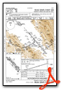
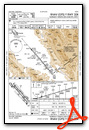
Chart Supplement

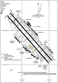
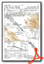
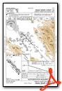
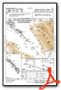
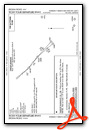
KSJC Airport Diagram
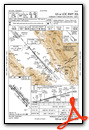
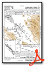
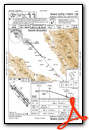
VFR Chart of KSJC
Sectional Charts at SkyVector.com
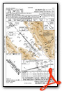
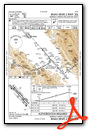
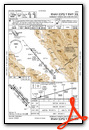
IFR Chart of KSJC
Enroute Charts at SkyVector.com
Location Information for KSJC
Coordinates: N37°21.78' / W121°55.72'Located 02 miles NW of San Jose, California on 1050 acres of land. View all Airports in California.
Surveyed Elevation is 62 feet MSL.
TPA 942 FT AGL SINGLE-ENGINE ACFT, 1442 FT AGL MULTI-ENGINE & TURBINE POWERED ACFT.
Operations Data
|
|
Airport Communications
| D-ATIS: | 126.95 (408-980-8459) |
|---|---|
| ASOS: | 126.95 Tel. 408-969-0838 |
| SAN JOSE TOWER: | 124.0 257.6 |
| SAN JOSE GROUND: | 121.7 |
| NORCAL APPROACH: | 120.1 125.35 126.475 134.5 290.25 290.25 317.775 338.2 |
| NORCAL DEPARTURE: | 121.3 270.35 |
| IC: | 257.6 120.1 290.25 |
| CLEARANCE DELIVERY: | 118.0 |
| SHVVR STAR: | 126.475 317.775 |
| CTAF: | 124.000 |
| SUNOL DP: | 121.3 270.35 |
| SAN JOSE DP: | 121.3 270.35 |
| BRINY STAR: | 133.95 317.6 |
| CLASS C: | 120.1 ;081-135 SJC 121.3 ;280-080 SJC 135.2 ;136-279 SJC 270.35 ;280-080 SJC 290.25 ;081-135 SJC 379.1 ;136-279 SJC |
| ROBIE STAR: | 124.525 348.675 |
| BMRNG DP: | 121.3 270.35 |
| JAWWS STAR: | 290.25 |
| TECKY DP: | 121.3 270.35 |
| ALMDN DP: | 121.3 270.35 |
| FRLON STAR: | 133.95 317.6 |
| PRE TAXI CLNC: | 118.0 |
| BRIXX STAR: | 133.95 317.6 |
| POINT REYES STAR: | 133.95 317.6 |
| LOUPE DP: | 121.3 270.35 |
| MOONY DP: | 121.3 270.35 |
| ALTAM DP: | 121.3 270.35 |
| UNICOM: | 122.950 |
| SILCN STAR: | 124.525 348.675 |
| DANVILLE DP: | 121.3 270.35 |
| ATIS at RHV (5.5 E): | 125.2 |
| AWOS-3PT at NUQ (6.3 NW): | 124.175 650-386-0655 |
| ATIS at NUQ (6.6 NW): | 283.0 |
Nearby Navigation Aids
|
| ||||||||||||||||||||||||||||||||||||


Runway 12L/30R
| Dimensions: | 11000 x 150 feet / 3353 x 46 meters | |
|---|---|---|
| Surface: | Concrete / Grooved in Good Condition | |
| Weight Limits: | 82 /R/B/W/T, S-220, D-250, ST-605 | |
| Edge Lighting: | High Intensity | |
| Runway 12L | Runway 30R | |
| Coordinates: | N37°22.50' / W121°56.41' | N37°21.14' / W121°54.92' |
| Elevation: | 37.7 | 61.1 |
| Traffic Pattern: | Left | Right |
| Runway Heading: | 139° True | 319° True |
| Displaced Threshold: | 1308 Feet | 2537 Feet |
| Declared Distances: | TORA:10139 TODA:11000 ASDA:10139 LDA:8831 | TORA:10134 TODA:11000 ASDA:10134 LDA:7597 |
| Markings: | Precision Instrument in good condition. | Precision Instrument in good condition. |
| Glide Slope Indicator | P4R (3.00° Glide Path Angle) | P4L (3.00° Glide Path Angle) |
| REIL: | Yes | |
| Centerline Lights: | Yes | Yes |
| Obstacles: | 32 ft Pole 1441 ft from runway, 580 ft right of center | 54 ft Tree 1435 ft from runway, 550 ft right of center |
Runway 12R/30L
| Dimensions: | 11000 x 150 feet / 3353 x 46 meters | |
|---|---|---|
| Surface: | Concrete / Grooved in Good Condition | |
| Weight Limits: | 67 /R/C/W/T, S-220, D-250, ST-605, DT-875 | |
| Edge Lighting: | High Intensity | |
| Runway 12R | Runway 30L | |
| Coordinates: | N37°22.42' / W121°56.52' | N37°21.06' / W121°55.02' |
| Elevation: | 38.2 | 62.1 |
| Traffic Pattern: | Right | Left |
| Runway Heading: | 139° True | 319° True |
| Displaced Threshold: | 1297 Feet | 2537 Feet |
| Declared Distances: | TORA:9883 TODA:11000 ASDA:9883 LDA:8587 | TORA:10152 TODA:11000 ASDA:10152 LDA:7614 |
| Markings: | Precision Instrument in good condition. | Precision Instrument in good condition. |
| Glide Slope Indicator | P4R (3.00° Glide Path Angle) | P4L (3.00° Glide Path Angle) RWY 30L PAPI UNUSBL BYD 7 DEGS OF CNTRLN OF RWY. |
| RVR Equipment | Touchdown Rollout | Touchdown Rollout |
| Approach Lights: | MALSR 1,400 Foot Medium-intensity Approach Lighting System with runway alignment indicator lights. | MALSR 1,400 Foot Medium-intensity Approach Lighting System with runway alignment indicator lights. |
| Centerline Lights: | Yes | Yes |
| Obstacles: | 29 ft Pole 580 ft from runway, 480 ft right of center APCH RATIO 50:1 TO DSPLCD THR. |
14 ft Fence 230 ft from runway, 170 ft right of center APCH RATIO 50:1 TO DSPLCD THR. |
Services Available
| Fuel: | 100LL (blue), Jet-A |
|---|---|
| Transient Storage: | Hangars,Tiedowns |
| Airframe Repair: | MAJOR |
| Engine Repair: | MAJOR |
| Bottled Oxygen: | HIGH/LOW |
| Bulk Oxygen: | HIGH/LOW |
| Other Services: | AIR FREIGHT SERVICES,AVIONICS,CARGO HANDLING SERVICES,CHARTER SERVICE,PILOT INSTRUCTION,AIRCRAFT RENTAL,AIRCRAFT SALES |
Ownership Information
| Ownership: | Publicly owned | |
|---|---|---|
| Owner: | CITY OF SAN JOSE | |
| 200 E. SANTA CLARA STREET | ||
| SAN JOSE, CA 95113 | ||
| 408-277-5100 | ||
| Manager: | JOHN AITKEN | |
| 1701 AIRPORT BLVD., SUITE B-1130 | ||
| SAN JOSE, CA 95110-1206 | ||
| (408) 277-5100 | ||
Operational Statistics
| Single Engine Aircraft Based on Field: | 66 | Statistics collected for 12 month period ending 2022-11-30 | |
|---|---|---|---|
| Multi-Engine Aircraft Based on Field: | 17 | Annual Commercial Operations: | 116738 |
| Jet Aircraft Based on Field: | 53 | Annual Commuter Operations: | none |
| Helicopters Based on Field: | 6 | Annual Air Taxi Operations: | 24344 |
| Military Aircraft Based on Field: | none | Annual Military Operations: | 18 |
| Gliders Based on Field: | none | Annual GA Local Operations: | 5541 |
| Ultralights Based on Field: | none | Annual GA Itinerant Operations: | 30587 |
Other Remarks
- TWY Y WILL BE PERIODICALLY RSTRD TO ACFT WITH A WINGSPAN OF LESS THAN 171 FT (MD-11 OR SMALLER) DRG B-787 AND B-747 OPNS ON RWY 12L/30R.
- TWY Z WILL BE PERIODICALLY RSTRD TO ACFT WITH A WINGSPAN OF LESS THAN 118 FT (B-737-900 OR SMALLER) DRG B-787 AND B-747 OPNS. TWY Z BTN 200 FT NW OF TWY H AND 200 FT NW OF TWY K LTD TO ACFT WITH WINGSPAN OF LESS THAN 135 FT (B-757-300 OR SMALLER).
- BIRDS FREQUENTLY ON OR IN VICINITY OF AIRPORT.
- TWY V LTD TO ACFT WITH WINGSPAN OF LESS THAN 118 FT (B-737-900 OR SMALLER).
- UNSCHEDULED OPNS BY GROUP 5 ACFT (B747) AND LARGER NOT AUTH EXCEPT WITH PRIOR ARPT APPROVAL CTC AMGR (408) 392-3500.
- NOISE ABATEMENT PROCEDURE: RY 30L/12R IS PREFERRED ARRIVAL RY FOR JET ACFT AND RY 12L/30R IS THE PREFERRED DEP RY FOR JET ACFT. ALL JET ACFT TKOFS ARE TO BE INITIATED FM EOR UNLESS DIRECTED OTHERWISE BY ATCT.
- CURFEW HRS 2300-0700 FAR 36 STAGE II, 2330-0630 FAR 36 STAGE III ACFT LISTED ON THE SCHEDULE OF AUTHORIZED AIRCRAFT ISSUED BY THE DIRECTOR OF AVIATION. DELAYED SCHEDULED FLIGHTS, AND ALTERNATE/EMERGENCY OPERATIONS MAY BE EXEMPT FROM CURFEW HOUR RESTRICTIONS.
- PRIOR AIRPORT NOTIFICATION IS REQUIRED FOR ALL LATE/EARLY ARRIVALS. CONTACT MANAGER ON DUTY AT (408) 392-3500.
- FIRST 400 FT RY 30R & RY 30L CLSD FOR TKOF DC10, MD11, L1011.
- ALL TURBINE ENGINE RUN-UPS REQUIRE PRIOR AIRPORT APPROVAL, CONTACT MGR ON DUTY (408) 392-3500.
- TWY D BETWEEN TWY W AND TWY V LIMITED TO ACFT WITH A WINGSPAN OF LESS THAN 118 FT (B-737-900 OR SMALLER).
- TWY W BETWEEN TWY J AND TWY L CAN SUPPORT GROUP IV ACFT.
- HIGH INTENSITY LIGHT ACTIVITY: HIGH INTENSITY LIGHTS (LASERS AND LARGE MEDIA SCREENS) MAY BE VISIBLE TO ARR AND DEP ACFT TO SAN JOSE INTERNATIONAL AIRPORT DURING EVENTS AT THE LEVI STADIUM COMPLEX (37-24-15N/121-58-14W, SJC VORTAC R-303/2.1 DME). FLIGHT CREWS SHOULD USE CAUTION WHEN OPERATING IN THIS AREA DURING STADIUM EVENTS. COCKPIT ILLUMINATION AND GLARE EFFECT REDUCING VIS MAY BE INTENSIFIED DURING ARR AND DEP OPS ESPECIALLY AT NIGHT.
- RRP RQRD FM FBO FOR TSNT HEL OPS.
- FOR CD WHEN ATCT IS CLSD CTC NORCAL APCH AT 916-361-3748.
- ACTVT MALSR RWY 12R, MALSR RWY 30L, HIRL RWY 12L/30R, HIRL RWY 12R/30L - FREQ 124.0 WHEN TWR CLSD.
- TPA 942 FT AGL SINGLE-ENGINE ACFT, 1442 FT AGL MULTI-ENGINE & TURBINE POWERED ACFT.
Weather Minimums
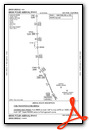
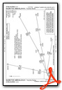
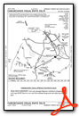
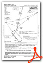
Standard Terminal Arrival (STAR) Charts
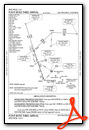
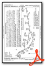
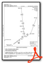
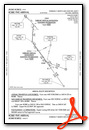
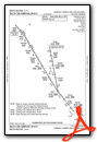
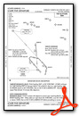
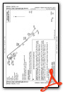
Instrument Approach Procedure (IAP) Charts
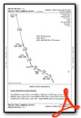
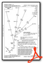
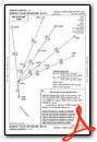
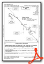
Departure Procedure (DP) Charts
Nearby Airports with Instrument Procedures
| ID | Name | Heading / Distance | ||
|---|---|---|---|---|
 |
KRHV | Reid-Hillview of Santa Clara County Airport | 109° | 5.5 |
|
KNUQ | Moffett Federal Airfield Airport | 298° | 6.6 |
|
KPAO | Palo Alto Airport | 303° | 10.7 |
|
KSQL | San Carlos Airport | 300° | 17.7 |
|
KHWD | Hayward Exec Airport | 332° | 20.0 |
|
KLVK | Livermore Municipal Airport | 014° | 20.5 |
|
E16 | San Martin Airport | 136° | 23.2 |
|
KOAK | Metro Oakland International Airport | 327° | 25.6 |
|
KSFO | San Francisco International Airport | 305° | 26.3 |
|
KWVI | Watsonville Municipal Airport | 165° | 26.5 |
|
KHAF | Half Moon Bay Airport | 288° | 28.8 |
|
KTCY | Tracy Municipal Airport | 049° | 30.4 |


