Login
Register


SLH
Cheboygan County Airport
Official FAA Data Effective 2024-04-18 0901Z
Chart Supplement

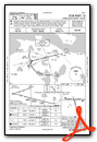
VFR Chart of KSLH
Sectional Charts at SkyVector.com
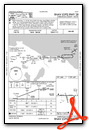
IFR Chart of KSLH
Enroute Charts at SkyVector.com
Location Information for KSLH
Coordinates: N45°39.22' / W84°31.16'Located 02 miles W of Cheboygan, Michigan on 350 acres of land. View all Airports in Michigan.
Surveyed Elevation is 639 feet MSL.
Operations Data
|
|
Airport Communications
| AWOS-3: | 118.175 Tel. 231-627-4671 |
|---|---|
| CTAF: | 122.800 |
| UNICOM: | 122.800 |
| ASOS at PLN (12.7 SW): | 119.025 231-539-7700 |
| AWOS-3 at MCD (13.6 N): | 118.275 906-847-3778 |
| AWOS-3P at MGN (21.5 SW): | 119.925 231-347-5231 |
- APCH/DEP SVC PRVDD BY MINNEAPOLIS ARTCC ON FREQS 134.6/354.05 (PELLSTON RCAG).
Nearby Navigation Aids
|
| ||||||||||||||||||||||||||||||||||||||||||||||||||||||||||||


Runway 10/28
| Dimensions: | 4004 x 75 feet / 1220 x 23 meters | |
|---|---|---|
| Surface: | Asphalt in Good Condition | |
| Weight Limits: | S-23, D-34, ST-60 | |
| Edge Lighting: | Medium Intensity | |
| Runway 10 | Runway 28 | |
| Coordinates: | N45°39.25' / W84°31.63' | N45°39.25' / W84°30.70' |
| Elevation: | 639.5 | 626.9 |
| Traffic Pattern: | Left | Left |
| Runway Heading: | 90° True | 270° True |
| Markings: | Non-Precision Instrument in good condition. | Non-Precision Instrument in good condition. |
| Glide Slope Indicator | P2L (4.00° Glide Path Angle) | P2L (4.00° Glide Path Angle) |
| REIL: | Yes | Yes |
| Obstacles: | 19 ft Road 380 ft from runway, 276 ft right of center | 33 ft Trees 376 ft from runway, 250 ft left of center |
Runway 17/35
| Dimensions: | 1874 x 60 feet / 571 x 18 meters | |
|---|---|---|
| Surface: | Asphalt in Good Condition | |
| Edge Lighting: | Medium Intensity | |
| Runway 17 | Runway 35 | |
| Coordinates: | N45°39.31' / W84°31.20' | N45°39.02' / W84°31.09' |
| Elevation: | 633.0 | 635.5 |
| Traffic Pattern: | Left | Left |
| Runway Heading: | 165° True | 345° True |
| Markings: | Basic in good condition. | Basic in good condition. |
| Obstacles: | 83 ft Trees 1427 ft from runway, 248 ft left of center | |
Services Available
| Fuel: | 100LL (blue), Jet A+ |
|---|---|
| Transient Storage: | NONE |
| Airframe Repair: | MAJOR |
| Engine Repair: | MAJOR |
| Bottled Oxygen: | NOT AVAILABLE |
| Bulk Oxygen: | NOT AVAILABLE |
| Other Services: | PILOT INSTRUCTION,AIRCRAFT RENTAL |
Ownership Information
| Ownership: | Publicly owned | |
|---|---|---|
| Owner: | CHEBOYGAN AIRPORT AUTHORITY | |
| 1520 LEVERING RD | ||
| CHEBOYGAN, MI 49721-9381 | ||
| 231-627-5571 | ||
| Manager: | MICHAEL JERMEAY | |
| 1520 LEVERING RD | ||
| CHEBOYGAN, MI 49721-9381 | ||
| 231-627-5571 | ||
Operational Statistics
| Single Engine Aircraft Based on Field: | 16 | Statistics collected for 12 month period ending 2018-12-31 | |
|---|---|---|---|
| Multi-Engine Aircraft Based on Field: | 1 | Annual Commercial Operations: | none |
| Jet Aircraft Based on Field: | none | Annual Commuter Operations: | none |
| Helicopters Based on Field: | none | Annual Air Taxi Operations: | none |
| Military Aircraft Based on Field: | none | Annual Military Operations: | none |
| Gliders Based on Field: | none | Annual GA Local Operations: | 3427 |
| Ultralights Based on Field: | none | Annual GA Itinerant Operations: | 3427 |
Other Remarks
- DEER & BIRDS ON & INVOF ARPT.
- AFT HRS TRML BLDG ACES: PRESS 5, THEN 3 & 2 SIMUL, THEN 1.
- FOR CD CTC MINNEAPOLIS ARTCC AT 651-463-5588.
- 0LL 100LL AVBL H24 SELF SVC; FOR JET A+ AFT HRS CALL 989-464-6887 OR 616-443-1010 SUBJ CALL-IN FEE.
- ACTVT REIL RWY 10 & 28; PAPI RWY 10 & 28; MIRL RWY 10/28 & 17/35 - 122.5.
Weather Minimums
Instrument Approach Procedure (IAP) Charts

Nearby Airports with Instrument Procedures
| ID | Name | Heading / Distance | ||
|---|---|---|---|---|
 |
6Y1 | Bois Blanc Island Airport | 005° | 6.8 |
|
KPLN | Pellston Regional/Emmet County Airport | 247° | 12.7 |
|
KMCD | Mackinac Island Airport | 338° | 13.6 |
|
83D | Mackinac County Airport | 327° | 17.0 |
|
KMGN | Harbor Springs Airport | 230° | 21.5 |
|
KPZQ | Presque Isle County Airport | 116° | 33.3 |
|
N98 | Boyne City Municipal Airport | 216° | 33.3 |
|
KBFA | Boyne Mountain Airport | 210° | 33.9 |
|
KCIU | Chippewa County International Airport | 003° | 35.9 |
|
KCVX | Charlevoix Municipal Airport | 237° | 38.2 |
|
KDRM | Drummond Island Airport | 056° | 38.9 |
|
KGLR | Gaylord Regional Airport | 191° | 39.2 |
Airport Images
Do you have a recent image of this airport? Upload it here!


