Login
Register


SLK
Adirondack Regional Airport
Official FAA Data Effective 2024-04-18 0901Z
Chart Supplement

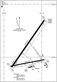
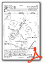
KSLK Airport Diagram
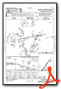
VFR Chart of KSLK
Sectional Charts at SkyVector.com
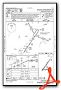
IFR Chart of KSLK
Enroute Charts at SkyVector.com
Location Information for KSLK
Coordinates: N44°23.12' / W74°12.37'Located 04 miles NW of Saranac Lake, New York on 1499 acres of land. View all Airports in New York.
Surveyed Elevation is 1662 feet MSL.
Operations Data
|
|
Airport Communications
| ASOS: | 124.175 Tel. 518-891-6696 |
|---|---|
| CTAF: | 123.000 |
| UNICOM: | 123.000 |
| AWOS-AV at MAL (28.6 N): | 122.8 (518) 651-2601 |
| ASOS at PBG (35.3 NE): | 132.225 518-324-5539 |
| AWOS-3P at PTD (36.2 NW): | 118.325 315-265-6106 |
- APCH/DEP SVC PRVDD BY BOSTON ARTCC ON FREQS 120.35/342.25 (ST. ALBANS RCAG).
Nearby Navigation Aids
|
| ||||||||||||||||||||||||||||||||||||||||||||||||||||||||||||


Runway 05/23
| Dimensions: | 6573 x 150 feet / 2003 x 46 meters | |
|---|---|---|
| Surface: | Asphalt / Grooved in Good Condition | |
| Weight Limits: | 64 /F/B/W/T, S-40, D-73, ST-115 | |
| Edge Lighting: | High Intensity | |
| Runway 05 | Runway 23 | |
| Coordinates: | N44°22.81' / W74°12.80' | N44°23.70' / W74°11.93' |
| Elevation: | 1640.0 | 1662.5 |
| Traffic Pattern: | Left | Left |
| Runway Heading: | 35° True | 215° True |
| Declared Distances: | TORA:6573 TODA:6573 ASDA:6573 LDA:6573 | TORA:6573 TODA:6573 ASDA:6333 LDA:6333 |
| Markings: | Non-Precision Instrument in fair condition. | Precision Instrument in fair condition. |
| Glide Slope Indicator | P4L (3.00° Glide Path Angle) | |
| Approach Lights: | MALSR 1,400 Foot Medium-intensity Approach Lighting System with runway alignment indicator lights. | |
| Obstacles: | 18 ft Trees 387 ft from runway, 387 ft left of center | 7 ft Trees 385 ft from runway, 532 ft right of center |
Runway 09/27
| Dimensions: | 3997 x 100 feet / 1218 x 30 meters | |
|---|---|---|
| Surface: | Asphalt in Good Condition | |
| Weight Limits: | 61 /F/B/W/T, S-40, D-73, ST-115 | |
| Edge Lighting: | Medium Intensity | |
| Runway 09 | Runway 27 | |
| Coordinates: | N44°22.83' / W74°12.83' | N44°22.95' / W74°11.93' |
| Elevation: | 1638.8 | 1638.3 |
| Traffic Pattern: | Left | Left |
| Runway Heading: | 79° True | 259° True |
| Displaced Threshold: | 400 Feet | |
| Declared Distances: | TORA:3997 TODA:3997 ASDA:3997 LDA:3997 | TORA:3997 TODA:3997 ASDA:3997 LDA:3597 |
| Markings: | Non-Standard in good condition. | Non-Precision Instrument in good condition. |
| Obstacles: | 27 ft Trees 214 ft from runway, 252 ft left of center | 18 ft Trees 387 ft from runway, 56 ft left of center |
Services Available
| Fuel: | 100LL (blue), Jet-A |
|---|---|
| Transient Storage: | Hangars,Tiedowns |
| Airframe Repair: | MAJOR |
| Engine Repair: | MAJOR |
| Bottled Oxygen: | NONE |
| Bulk Oxygen: | NONE |
| Other Services: | CHARTER SERVICE |
Ownership Information
| Ownership: | Publicly owned | |
|---|---|---|
| Owner: | TOWN OF HARRIETSTOWN | |
| 39 MAIN STREET | ||
| SARANAC LAKE, NY 12983 | ||
| 518-891-1470 | ||
| Manager: | COREY HURWITCH | |
| 96 AIRPORT ROAD | ||
| SARANAC LAKE, NY 12983 | ||
| 518-891-4600 | ||
Operational Statistics
| Single Engine Aircraft Based on Field: | 10 | Statistics collected for 12 month period ending 2023-06-30 | |
|---|---|---|---|
| Multi-Engine Aircraft Based on Field: | 4 | Annual Commercial Operations: | none |
| Jet Aircraft Based on Field: | none | Annual Commuter Operations: | none |
| Helicopters Based on Field: | 2 | Annual Air Taxi Operations: | 1614 |
| Military Aircraft Based on Field: | none | Annual Military Operations: | 152 |
| Gliders Based on Field: | none | Annual GA Local Operations: | 870 |
| Ultralights Based on Field: | none | Annual GA Itinerant Operations: | 3480 |
Other Remarks
- TWY B UNAVBL TO ACFT WITH WINGSPAN 79 FT & ABV.
- COLD TEMPERATURE AIRPORT. ALTITUDE CORRECTION REQUIRED AT OR BELOW -29C.
- FOR CD IF UNA TO CTC ON FREQ, CTC BOSTON ARTCC AT 603-879-6859.
- NSTD MKGS; THLD MKGS 400 FT FM RY END.
- ACTVT HIRL RY 05/23, MIRL RY 09/27, MALSR RY 23, PAPI RY 05, & TWY LGTS - CTAF.
Weather Minimums
Instrument Approach Procedure (IAP) Charts
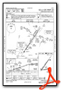
Nearby Airports with Instrument Procedures
| ID | Name | Heading / Distance | ||
|---|---|---|---|---|
 |
KLKP | Lake Placid Airport | 124° | 12.8 |
|
KMAL | Malone-Dufort Airport | 349° | 28.6 |
|
KPBG | Plattsburgh International Airport | 063° | 35.5 |
|
KPTD | Potsdam Municipal/Damon Field Airport | 299° | 36.3 |
|
KMSS | Massena International-Richards Field Airport | 320° | 42.9 |
|
KBTV | Patrick Leahy Burlington International Airport | 083° | 45.6 |
|
4B6 | Ticonderoga Municipal Airport | 131° | 45.9 |
|
KOGS | Ogdensburg International Airport | 288° | 56.8 |
|
K09 | Piseco Airport | 193° | 57.5 |
|
KFSO | Franklin County State Airport | 054° | 58.0 |
|
CYJN | St Jean Airport | 035° | 67.3 |
|
KGFL | Floyd Bennett Memorial Airport | 157° | 67.8 |
Airport Images
Do you have a recent image of this airport? Upload it here!


