Login
Register


SNL
Shawnee Regional Airport
Official FAA Data Effective 2024-04-18 0901Z
Chart Supplement

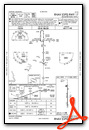
VFR Chart of KSNL
Sectional Charts at SkyVector.com
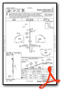
IFR Chart of KSNL
Enroute Charts at SkyVector.com
Location Information for KSNL
Coordinates: N35°21.44' / W96°56.57'Located 02 miles NW of Shawnee, Oklahoma on 520 acres of land. View all Airports in Oklahoma.
Surveyed Elevation is 1073 feet MSL.
Operations Data
|
|
Airport Communications
| AWOS-3: | 118.275 Tel. 405-878-1745 |
|---|---|
| OKE CITY APPROACH: | 120.45 288.325 |
| OKE CITY DEPARTURE: | 120.45 288.325 |
| UNICOM: | 122.700 |
| CTAF: | 122.700 |
| AWOS-3 at SRE (14.0 E): | 118.625 405-382-0111 |
| ATIS at TIK (22.0 W): | 270.1 |
| AWOS-3PT at CQB (22.8 N): | 119.275 405-258-6724 |
Nearby Navigation Aids
|
| ||||||||||||||||||||||||||||||||||||||||||||||||||||||||||||


Runway 17/35
| Dimensions: | 5997 x 100 feet / 1828 x 30 meters | |
|---|---|---|
| Surface: | Asphalt in Good Condition | |
| Weight Limits: | S-30, D-40, ST-60 | |
| Edge Lighting: | Medium Intensity | |
| Runway 17 | Runway 35 | |
| Coordinates: | N35°21.93' / W96°56.57' | N35°20.94' / W96°56.57' |
| Elevation: | 1069.1 | 1067.7 |
| Traffic Pattern: | Right | Left |
| Runway Heading: | 180° True | 360° True |
| Displaced Threshold: | 404 Feet | |
| Markings: | Precision Instrument in good condition. | Precision Instrument in good condition. |
| Glide Slope Indicator | P4L (3.00° Glide Path Angle) | P4L (3.00° Glide Path Angle) |
| Approach Lights: | MALSR 1,400 Foot Medium-intensity Approach Lighting System with runway alignment indicator lights. | |
| REIL: | Yes | Yes |
| Obstacles: | 24 ft Power Line 1278 ft from runway, 225 ft left of center | 29 ft Trees 975 ft from runway |
Services Available
| Fuel: | 100LL (blue), Jet-A |
|---|---|
| Transient Storage: | Hangars,Tiedowns |
| Airframe Repair: | MINOR |
| Engine Repair: | MINOR |
| Bottled Oxygen: | HIGH |
| Bulk Oxygen: | NONE |
| Other Services: | PILOT INSTRUCTION,PARACHUTE JUMP ACTIVITY,AIRCRAFT RENTAL |
Ownership Information
| Ownership: | Publicly owned | |
|---|---|---|
| Owner: | CITY OF SHAWNEE | |
| PO BOX 1448 | ||
| SHAWNEE, OK 74802-1448 | ||
| (405) 878-1633 | ||
| Manager: | BONNIE WILSON | |
| 2202 AIRPORT DR. | ||
| SHAWNEE, OK 74804 | ||
| 405-878-1625 | ||
Operational Statistics
| Single Engine Aircraft Based on Field: | 25 | Statistics collected for 12 month period ending 2018-05-22 | |
|---|---|---|---|
| Multi-Engine Aircraft Based on Field: | 5 | Annual Commercial Operations: | none |
| Jet Aircraft Based on Field: | 2 | Annual Commuter Operations: | none |
| Helicopters Based on Field: | 5 | Annual Air Taxi Operations: | none |
| Military Aircraft Based on Field: | none | Annual Military Operations: | 50 |
| Gliders Based on Field: | none | Annual GA Local Operations: | 4617 |
| Ultralights Based on Field: | none | Annual GA Itinerant Operations: | 4515 |
Other Remarks
- THIS AIRPORT HAS BEEN SURVEYED BY THE NATIONAL GEODETIC SURVEY.
- FOR CD CTC OKE APCH AT 405-681-5683.
- 0LL FUEL AVBL 24 HRS WITH CREDIT CARD.
- MIRL RWY 17/35 PRESET LOW INTST; TO INCR INTST & ACTVT MALSR RWY 17 - CTAF.
Weather Minimums

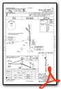
Standard Terminal Arrival (STAR) Charts
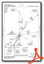
Instrument Approach Procedure (IAP) Charts
Nearby Airports with Instrument Procedures
| ID | Name | Heading / Distance | ||
|---|---|---|---|---|
 |
O47 | Prague Municipal Airport | 055° | 13.2 |
|
KSRE | Seminole Municipal Airport | 110° | 14.0 |
|
KTIK | Tinker AFB Airport | 279° | 22.0 |
|
KCQB | Chandler Regional Airport | 015° | 22.8 |
|
KOUN | University of Oklahoma Westheimer Airport | 255° | 26.8 |
|
1K4 | David Jay Perry Airport | 245° | 28.6 |
|
F99 | Holdenville Municipal Airport | 122° | 30.6 |
|
KOKC | Will Rogers World Airport | 273° | 32.4 |
|
KADH | Ada Regional Airport | 157° | 35.7 |
|
KPWA | Wiley Post Airport | 287° | 36.1 |
|
KCUH | Cushing Municipal Airport | 013° | 36.5 |
|
3F7 | Jones Memorial Airport | 043° | 37.1 |
Airport Images

By: dghmd

By: Dave


