Login
Register


SNS
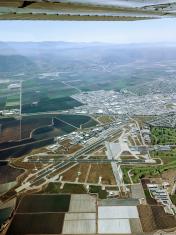
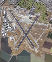
Salinas Municipal Airport
Official FAA Data Effective 2024-04-18 0901Z
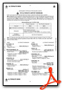
Chart Supplement

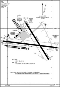
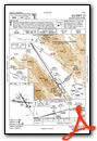
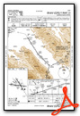
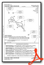
KSNS Airport Diagram
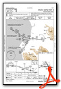
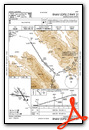
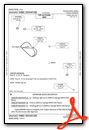
VFR Chart of KSNS
Sectional Charts at SkyVector.com
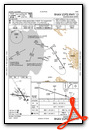
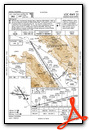
IFR Chart of KSNS
Enroute Charts at SkyVector.com
Location Information for KSNS
Coordinates: N36°39.74' / W121°36.43'Located 03 miles SE of Salinas, California on 605 acres of land. View all Airports in California.
Surveyed Elevation is 84 feet MSL.
Operations Data
|
|
Airport Communications
| ATIS: | 124.85 |
|---|---|
| ASOS: | Tel. 831-422-2830 |
| SALINAS TOWER: | 119.525 239.3 |
| SALINAS GROUND: | 121.7 |
| NORCAL APPROACH: | 133.0 ;001-135 MRY 251.15 ;001-135 MRY |
| NORCAL DEPARTURE: | 133.0 ;001-135 MRY 251.15 ;001-135 MRY |
| IC: | 133.0 ;001-135 MRY 251.15 ;001-135 MRY |
| CLASS C: | 133.0 ;001-135 MRY 251.15 ;001-135 MRY |
| CTAF: | 119.525 |
| UNICOM: | 123.000 |
| AWOS-3PT at OAR (7.3 W): | 134.025 831-384-2967 |
| ATIS at MRY (12.2 W): | 119.25 |
| ASOS at MRY (12.4 W): | 831-642-0241 |
Nearby Navigation Aids
|
| ||||||||||||||||||||||||||||||||||||||||||


Runway 08/26
| Dimensions: | 6004 x 150 feet / 1830 x 46 meters | |
|---|---|---|
| Surface: | Asphalt in Good Condition | |
| Weight Limits: | S-80, D-136, ST-244 | |
| Edge Lighting: | Medium Intensity | |
| Runway 08 | Runway 26 | |
| Coordinates: | N36°39.77' / W121°37.11' | N36°39.66' / W121°35.89' |
| Elevation: | 69.6 | 83.8 |
| Traffic Pattern: | Right | Left |
| Runway Heading: | 97° True | 277° True |
| Displaced Threshold: | 396 Feet | |
| Markings: | Non-Precision Instrument in good condition. | Non-Precision Instrument in good condition. |
| Glide Slope Indicator | V2L (3.00° Glide Path Angle) | V2L (3.00° Glide Path Angle) |
| REIL: | Yes | |
Runway 13/31
| Dimensions: | 4825 x 150 feet / 1471 x 46 meters 200 FT ASPH STWY RY 31. | |
|---|---|---|
| Surface: | Asphalt in Good Condition | |
| Weight Limits: | S-120, D-235, ST-401, DT-935 | |
| Edge Lighting: | High Intensity | |
| Runway 13 | Runway 31 | |
| Coordinates: | N36°40.12' / W121°36.60' | N36°39.44' / W121°36.07' |
| Elevation: | 84.4 | 82.0 |
| Traffic Pattern: | Left | Right |
| Runway Heading: | 148° True | 328° True |
| Markings: | Precision Instrument in good condition. | Precision Instrument in good condition. |
| Glide Slope Indicator | V4L (3.00° Glide Path Angle) | P2L (3.00° Glide Path Angle) |
| RVR Equipment | Rollout | Touchdown |
| Approach Lights: | MALSR 1,400 Foot Medium-intensity Approach Lighting System with runway alignment indicator lights. | |
| REIL: | Yes | |
| Obstacles: | 45 ft Trees 1733 ft from runway, 310 ft right of center | |
Helipad H1
| Dimensions: | 90 x 90 feet / 27 x 27 meters | |
|---|---|---|
| Surface: | Asphalt-Concrete / Aggregate Friction Seal Coated | |
| Edge Lighting: | FLD | |
Services Available
| Fuel: | 100LL (blue), Jet-A |
|---|---|
| Transient Storage: | Hangars,Tiedowns |
| Airframe Repair: | MAJOR |
| Engine Repair: | MAJOR |
| Bottled Oxygen: | HIGH |
| Bulk Oxygen: | NONE |
| Other Services: | CROP DUSTING SERVICES,CHARTER SERVICE,PILOT INSTRUCTION,AIRCRAFT RENTAL,AIRCRAFT SALES |
Ownership Information
| Ownership: | Publicly owned | |
|---|---|---|
| Owner: | CITY OF SALINAS | |
| 200 LINCOLN AVE | ||
| SALINAS, CA 93901 | ||
| 831-758-7214 | ||
| Manager: | EARL PAISANT | |
| 30 MORTENSEN AVE | ||
| SALINAS, CA 93905 | ||
| 831-758-7214 | ||
Operational Statistics
| Single Engine Aircraft Based on Field: | 143 | Statistics collected for 12 month period ending 2019-12-10 | |
|---|---|---|---|
| Multi-Engine Aircraft Based on Field: | 10 | Annual Commercial Operations: | none |
| Jet Aircraft Based on Field: | 5 | Annual Commuter Operations: | none |
| Helicopters Based on Field: | 8 | Annual Air Taxi Operations: | 1335 |
| Military Aircraft Based on Field: | none | Annual Military Operations: | 500 |
| Gliders Based on Field: | 3 | Annual GA Local Operations: | 31500 |
| Ultralights Based on Field: | none | Annual GA Itinerant Operations: | 36775 |
Other Remarks
- PORTIONS OF TWY B BETWEEN D & N LIMITED ATCT SERVICES PROVIDED
- 6 FT TALL SECURITY FENCE 400 FT PRIOR TO RY 13 THLD ON CNTRLN AND STEEPLY DESCENDING TERRAIN 350 FT PRIOR TO RY 31 THLD ON CNTRLN BOTH IN RY 13/31 SAFETY AREA.
- FOR CD WHEN ATCT IS CLSD CTC NORCAL APCH AT 916-361-3748.
- WHEN ATCT CLSD ACTVT MALSR RWY 31; REIL RWY 13 & 26; PAPI RWY 31; HIRL RWY 13/31; MIRL RWY 08/26; H1 - CTAF. VASI RWY 08, 13, & 26 OPR CONSLY.
Weather Minimums
Instrument Approach Procedure (IAP) Charts
Departure Procedure (DP) Charts
Nearby Airports with Instrument Procedures
| ID | Name | Heading / Distance | ||
|---|---|---|---|---|
 |
KOAR | Marina Municipal Airport | 278° | 7.5 |
|
KMRY | Monterey Regional Airport | 248° | 12.2 |
|
KCVH | Hollister Municipal Airport | 034° | 16.8 |
|
KWVI | Watsonville Municipal Airport | 331° | 18.6 |
|
E16 | San Martin Airport | 001° | 25.1 |
|
KRHV | Reid-Hillview of Santa Clara County Airport | 345° | 41.5 |
|
KLSN | Los Banos Municipal Airport | 055° | 42.9 |
|
KSJC | Norman Y Mineta San Jose International Airport | 339° | 44.7 |
|
KNUQ | Moffett Federal Airfield Airport | 334° | 49.9 |
|
KPAO | Palo Alto Airport | 333° | 53.7 |
|
F34 | Firebaugh Airport | 077° | 56.3 |
|
KSQL | San Carlos Airport | 328° | 59.5 |