Login
Register


SRC
Searcy Regional Airport
Official FAA Data Effective 2024-04-18 0901Z
Chart Supplement

VFR Chart of KSRC
Sectional Charts at SkyVector.com
IFR Chart of KSRC
Enroute Charts at SkyVector.com
Location Information for KSRC
Coordinates: N35°12.64' / W91°44.25'Located 03 miles S of Searcy, Arkansas on 330 acres of land. View all Airports in Arkansas.
Surveyed Elevation is 264 feet MSL.
Operations Data
|
|
Airport Communications
| AWOS-3PT: | 128.325 Tel. 501-268-4280 |
|---|---|
| LITTLE ROCK APPROACH: | 119.75 291.775 |
| LITTLE ROCK DEPARTURE: | 119.75 291.775 |
| CLEARANCE DELIVERY: | 119.75 |
| UNICOM: | 122.700 |
| CTAF: | 122.700 |
| AWOS-2 at 4M3 (24.4 S): | 119.275 870-552-1445 |
| ATIS at LRF (26.7 SW): | 251.1 |
| AWOS-3PT at BVX (31.3 N): | 126.375 870-251-1369 |
Nearby Navigation Aids
|
| ||||||||||||||||||||||||||||||||||||||||||||||||||||||||||||


Runway 01/19
| Dimensions: | 6008 x 100 feet / 1831 x 30 meters | |
|---|---|---|
| Surface: | Asphalt in Good Condition | |
| Weight Limits: | S-24 | |
| Edge Lighting: | Medium Intensity | |
| Runway 01 | Runway 19 | |
| Coordinates: | N35°12.15' / W91°44.38' | N35°13.12' / W91°44.12' |
| Elevation: | 235.4 | 264.5 |
| Traffic Pattern: | Left | Left |
| Runway Heading: | 13° True | 193° True |
| Markings: | Precision Instrument in good condition. | Precision Instrument in good condition. |
| Glide Slope Indicator | P4L (3.00° Glide Path Angle) | P4L (3.00° Glide Path Angle) |
| Approach Lights: | MALSR 1,400 Foot Medium-intensity Approach Lighting System with runway alignment indicator lights. | |
| REIL: | Yes | |
| Obstacles: | 25 ft Tree 1050 ft from runway, 300 ft right of center | |
Services Available
| Fuel: | 100LL (blue), Jet-A |
|---|---|
| Transient Storage: | Hangars,Tiedowns |
| Airframe Repair: | MAJOR |
| Engine Repair: | MAJOR |
| Bottled Oxygen: | HIGH |
| Bulk Oxygen: | HIGH |
| Other Services: | CROP DUSTING SERVICES,PILOT INSTRUCTION,AIRCRAFT RENTAL,AIRCRAFT SALES |
Ownership Information
| Ownership: | Publicly owned | |
|---|---|---|
| Owner: | CITY OF SEARCY | |
| 401 WEST ARCH | ||
| SEARCY, AR 72143 | ||
| 501-268-2483 | ||
| Manager: | ROGER PEARSON | |
| 2609 S MAIN | ||
| SEARCY, AR 72143 | ||
| 501-279-1080 | ||
Operational Statistics
| Single Engine Aircraft Based on Field: | 78 | Statistics collected for 12 month period ending 2020-07-31 | |
|---|---|---|---|
| Multi-Engine Aircraft Based on Field: | 22 | Annual Commercial Operations: | none |
| Jet Aircraft Based on Field: | 4 | Annual Commuter Operations: | none |
| Helicopters Based on Field: | 9 | Annual Air Taxi Operations: | 1000 |
| Military Aircraft Based on Field: | none | Annual Military Operations: | 560 |
| Gliders Based on Field: | none | Annual GA Local Operations: | 20000 |
| Ultralights Based on Field: | none | Annual GA Itinerant Operations: | 10000 |
Other Remarks
- NUMEROUS AGRICULTURAL ACFT OPNS FM FEB-NOV 500 FT AGL & BLO.
- NUMEROUS GYROCOPTER OPNS DALGT HRS.
- NUMEROUS STUDENT PILOT OPNS.
- NO LINE OF SIGHT BTN RY ENDS - SMALL ACFT.
- FOR CD WHEN UNA VIA FREQ CTC LITTLE ROCK APCH 501-379-2908 OR LITTLE ROCK ATCT 501-379-2911
- 0LL 100LL AVBL SELF SERVE WITH CREDIT CARD. FOR JET A FUEL OR SVC AFT HRS CALL 501-279-1080.
- DUSK-DAWN. MIRL RY 01/19 PRESET LOW INTST; TO INCR INTST ACTVT - CTAF.
Weather Minimums

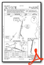
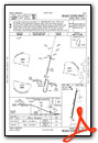
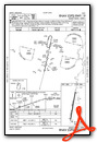
Instrument Approach Procedure (IAP) Charts
Nearby Airports with Instrument Procedures
| ID | Name | Heading / Distance | ||
|---|---|---|---|---|
 |
KHBZ | Heber Springs Municipal Airport | 323° | 22.5 |
|
M60 | Woodruff County Airport | 080° | 23.3 |
|
4M3 | Carlisle Municipal Airport | 177° | 24.1 |
|
KLRF | Little Rock AFB Airport | 228° | 26.7 |
|
KBVX | Batesville Regional Airport | 008° | 31.2 |
|
M36 | Frank Federer Memorial Airport | 125° | 34.0 |
|
KORK | North Little Rock Municipal Airport | 228° | 34.0 |
|
KLIT | Bill and Hillary Clinton Ntl/Adams Field Airport | 219° | 37.5 |
|
KSGT | Stuttgart Municipal Carl Humphrey Field Airport | 167° | 37.5 |
|
M19 | Newport Regional Airport | 046° | 37.6 |
|
KCXW | Conway Regional Airport | 254° | 41.8 |
|
2A2 | Holley Mountain Airpark Airport | 309° | 42.0 |
Airport Images
Do you have a recent image of this airport? Upload it here!


