Login
Register


STC
St Cloud Regional Airport
Official FAA Data Effective 2024-04-18 0901Z
Chart Supplement

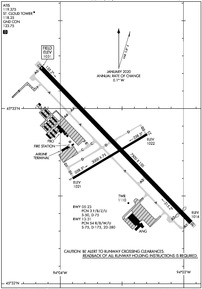
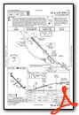
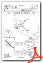
KSTC Airport Diagram
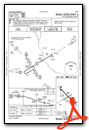
VFR Chart of KSTC
Sectional Charts at SkyVector.com
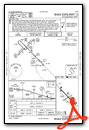
IFR Chart of KSTC
Enroute Charts at SkyVector.com
Location Information for KSTC
Coordinates: N45°32.77' / W94°3.56'Located 04 miles E of St Cloud, Minnesota on 1414 acres of land. View all Airports in Minnesota.
Estimated Elevation is 1030 feet MSL.
Operations Data
|
|
Airport Communications
| ATIS: | 119.375 |
|---|---|
| ASOS: | 125.075 Tel. 320-240-8781 |
| ST CLOUD TOWER: | 118.25 |
| ST CLOUD GROUND: | 123.75 |
| CTAF: | 118.250 |
| AWOS-3 at MGG (18.9 S): | 128.325 320-963-3300 |
| AWOS-3 at PNM (19.0 E): | 119.025 763-389-0615 |
| AWOS-3PT at CFE (25.0 S): | 120.45 763-684-0762 |
- APCH/DEP SVC PRVDD BY MINNEAPOLIS ARTCC ON FREQS 121.05/235.775 (PRINCETON RCAG).
- COMMUNICATIONS PRVDD BY PRINCETON RADIO ON FREQ 122.5 (ST CLOUD RCO).
Nearby Navigation Aids
|
| ||||||||||||||||||||||||||||||||||||||||||||||||||||||||||||


Runway 13/31
RWY 13/31 200 FT BLAST PAD EACH END. | ||
| Dimensions: | 7500 x 150 feet / 2286 x 46 meters | |
|---|---|---|
| Surface: | Concrete / Grooved in Good Condition | |
| Weight Limits: | 54 /R/B/W/U, S-75, D-175, ST-280 | |
| Edge Lighting: | High Intensity | |
| Runway 13 | Runway 31 | |
| Coordinates: | N45°33.24' / W94°4.16' | N45°32.35' / W94°2.94' |
| Elevation: | 1030.5 | 1015.9 |
| Traffic Pattern: | Left | Left |
| Runway Heading: | 136° True | 316° True |
| Displaced Threshold: | 500 Feet | |
| Declared Distances: | TORA:7500 TODA:7500 ASDA:7000 LDA:7000 | TORA:7500 TODA:7500 ASDA:7500 LDA:7000 |
| Markings: | Precision Instrument in fair condition. | Precision Instrument in fair condition. |
| Glide Slope Indicator | P4R (3.00° Glide Path Angle) | P4L (3.00° Glide Path Angle) |
| Approach Lights: | MALSR 1,400 Foot Medium-intensity Approach Lighting System with runway alignment indicator lights. | MALSR 1,400 Foot Medium-intensity Approach Lighting System with runway alignment indicator lights. |
| Obstacles: | 24 ft Trees 996 ft from runway, 255 ft right of center | |
Runway 05/23
RWY 05/23 NOT AVBL FOR SKEDD ACR OPNS WITH MORE THAN 9 PSGR SEATS OR UNSKED ACR AT LEAST 31 PSGR SEATS. | ||
| Dimensions: | 3000 x 75 feet / 914 x 23 meters | |
|---|---|---|
| Surface: | Asphalt in Good Condition | |
| Weight Limits: | 3 /F/B/Z/U, S-50, D-75 | |
| Edge Lighting: | Medium Intensity | |
| Runway 05 | Runway 23 | |
| Coordinates: | N45°32.60' / W94°3.90' | N45°32.85' / W94°3.30' |
| Elevation: | 1021.1 | 1022.0 |
| Traffic Pattern: | Left | Left |
| Runway Heading: | 59° True | 239° True |
| Declared Distances: | TORA:3000 TODA:3000 ASDA:3000 LDA:3000 | TORA:3000 TODA:3000 ASDA:3000 LDA:3000 |
| Markings: | Basic in good condition. | Basic in good condition. |
| Glide Slope Indicator | P4R (3.00° Glide Path Angle) | P4L (3.00° Glide Path Angle) |
| Obstacles: | 69 ft Trees 2050 ft from runway, 412 ft right of center | |
Services Available
| Fuel: | 100LL (blue), Jet-A |
|---|---|
| Transient Storage: | Hangars,Tiedowns |
| Airframe Repair: | MAJOR |
| Engine Repair: | MAJOR |
| Bottled Oxygen: | NONE |
| Bulk Oxygen: | HIGH |
| Other Services: | AVIONICS,PILOT INSTRUCTION,AIRCRAFT RENTAL,AIRCRAFT SALES |
Ownership Information
| Ownership: | Publicly owned | |
|---|---|---|
| Owner: | ST CLOUD RGNL ARPT AUTH | |
| 1550 45TH AVE SE STE 1 | ||
| SAINT CLOUD, MN 56304-9634 | ||
| 320-255-7292 | ||
| Manager: | BILL P TOWLE | WILLIAM.TOWLE@CI.STCLOUD.MN.US. |
| 1550 45TH AVE SE STE 1 | ||
| SAINT CLOUD, MN 56304-9634 | ||
| 320-255-7292 | ||
Operational Statistics
| Single Engine Aircraft Based on Field: | 81 | Statistics collected for 12 month period ending 2022-12-31 | |
|---|---|---|---|
| Multi-Engine Aircraft Based on Field: | 2 | Annual Commercial Operations: | 229 |
| Jet Aircraft Based on Field: | 8 | Annual Commuter Operations: | none |
| Helicopters Based on Field: | 1 | Annual Air Taxi Operations: | 1414 |
| Military Aircraft Based on Field: | 12 | Annual Military Operations: | 3915 |
| Gliders Based on Field: | none | Annual GA Local Operations: | 14950 |
| Ultralights Based on Field: | none | Annual GA Itinerant Operations: | 13774 |
Other Remarks
- RY 31 CALM WIND RY.
- DEER, MIGRATORY WATERFOWL, AND OTHER WILDLIFE ON & INVOF ARPT.
- FLIGHT TRAINING ON & INVOF ARPT.
- CROP DUSTING OPERATIONS ON AND IN VICINITY OF AIRPORT DURING SUMMER MONTHS.
- HELIPAD NOT VISIBLE FROM ATCT AND APPROACH SURFACES.
- LINE OF SIGHT VISIBILITY IS RESTRICTED FROM THE 13 & 23 APPROACH AND RUNWAY 13 & 5 APPROACH
- FOR CD WHEN ATCT IS CLSD CTC FSS VIA RCO, IF UNA CTC MINNEAPOLIS ARTCC AT 651-463-5588.
- ACTVT MALSR RWY 13 & 31 - CTAF. PAPI 13 & 31; HIRL RWY 13/31; MIRL RWY 05/23 PRESET ON LOW INTST, TO INCR INTST & ACTVT - CTAF.
Weather Minimums
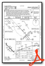
Instrument Approach Procedure (IAP) Charts

Nearby Airports with Instrument Procedures
| ID | Name | Heading / Distance | ||
|---|---|---|---|---|
 |
KMGG | Maple Lake Municipal-Bill Mavencamp Sr Field Airport | 170° | 18.9 |
|
KPNM | Princeton Municipal Airport | 087° | 19.0 |
|
KCFE | Buffalo Municipal Airport | 158° | 25.0 |
|
KLXL | Little Falls/Morrison County-Lindbergh Field Airport | 333° | 27.0 |
|
KPEX | Paynesville Municipal Airport | 250° | 30.8 |
|
KLJF | Litchfield Municipal Airport | 215° | 33.0 |
|
KCBG | Cambridge Municipal Airport | 088° | 33.5 |
|
KRYM | Ray S Miller AAF Airport | 338° | 35.0 |
|
D39 | Sauk Centre Municipal Airport | 284° | 38.0 |
|
KJMR | Mora Municipal Airport | 057° | 39.0 |
|
14Y | Todd Field Airport | 301° | 40.2 |
|
KMIC | Crystal Airport | 133° | 41.7 |
Airport Images
Do you have a recent image of this airport? Upload it here!


