Login
Register


STS
Charles M Schulz - Sonoma County Airport
Official FAA Data Effective 2024-04-18 0901Z
From the Flight Deck
Chart Supplement

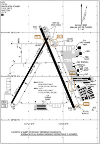
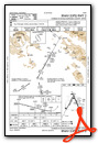
KSTS Airport Diagram
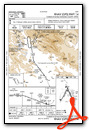
VFR Chart of KSTS
Sectional Charts at SkyVector.com
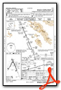
IFR Chart of KSTS
Enroute Charts at SkyVector.com
Location Information for KSTS
Coordinates: N38°30.58' / W122°48.77'Located 06 miles NW of Santa Rosa, California on 1125 acres of land. View all Airports in California.
Surveyed Elevation is 128 feet MSL.
TPA FOR SMALL ACFT 1,000 FT AGL AND TPA FOR LARGE ACFT 1,500 FT AGL.
Operations Data
|
|
Airport Communications
| ATIS: | 120.55 (707-545-2847) |
|---|---|
| ASOS: | 120.55 Tel. 707-573-8393 |
| SANTA ROSA TOWER: | 118.5 363.0 |
| SANTA ROSA GROUND: | 121.9 |
| UNICOM: | 122.950 |
| CTAF: | 118.500 |
| EMERG: | 121.5 |
| AWOS-3P at O69 (17.8 SE): | 132.325 707-773-1529 |
| AWOS-3P at DVO (25.2 SE): | 120.675 415-897-2236 |
| AWOS-3 at 1O2 (29.0 N): | 118.35 707-262-0380 |
- APCH/DEP CTL SVC PRVDD BY OAKLAND ARTCC (ZOA) ON FREQ 127.8/353.5 (MOUNT TAMALPAIS RCAG).
Nearby Navigation Aids
|
| ||||||||||||||||||||||||||||||||||||


Runway 14/32
| Dimensions: | 6000 x 150 feet / 1829 x 46 meters | |
|---|---|---|
| Surface: | Asphalt / Grooved in Good Condition | |
| Weight Limits: | 52 /F/C/W/T, S-120, D-184, ST-300 | |
| Edge Lighting: | High Intensity | |
| Runway 14 | Runway 32 | |
| Coordinates: | N38°31.05' / W122°48.83' | N38°30.14' / W122°48.34' |
| Elevation: | 110.5 | 120.4 |
| Traffic Pattern: | Right | Left |
| Runway Heading: | 157° True | 337° True |
| Declared Distances: | TORA:6000 TODA:6000 ASDA:5880 LDA:5880 | TORA:6000 TODA:6000 ASDA:6000 LDA:6000 |
| Markings: | Precision Instrument in good condition. | Precision Instrument in good condition. |
| Glide Slope Indicator | P4R (3.00° Glide Path Angle) | |
| RVR Equipment | Rollout | Touchdown |
| Approach Lights: | MALSR 1,400 Foot Medium-intensity Approach Lighting System with runway alignment indicator lights. | |
| REIL: | Yes | |
| Obstacles: | 17 ft Trees 800 ft from runway, 250 ft left of center | 135 ft Trees 6400 ft from runway |
Runway 02/20
| Dimensions: | 5202 x 100 feet / 1586 x 30 meters | |
|---|---|---|
| Surface: | Asphalt / Grooved in Good Condition | |
| Weight Limits: | 43 /F/C/W/T, S-109, D-154, ST-254 | |
| Edge Lighting: | Medium Intensity | |
| Runway 02 | Runway 20 | |
| Coordinates: | N38°30.19' / W122°49.26' | N38°30.94' / W122°48.73' |
| Elevation: | 128.5 | 113.3 |
| Traffic Pattern: | Left | Left |
| Runway Heading: | 29° True | 209° True |
| Declared Distances: | TORA:5202 TODA:5202 ASDA:4802 LDA:4802 | TORA:5202 TODA:5202 ASDA:5202 LDA:5202 |
| Markings: | Non-Precision Instrument in good condition. | Basic in good condition. |
| Glide Slope Indicator | P2L (3.00° Glide Path Angle) PAPI UNUSBL BYD 5 DEG LEFT OF CNTRLN | P4L (3.50° Glide Path Angle) |
| Obstacles: | 131 ft Trees 2900 ft from runway | 33 ft Trees 1200 ft from runway, 200 ft right of center |
Services Available
| Fuel: | 100LL (blue), Jet-A |
|---|---|
| Transient Storage: | Tiedowns |
| Airframe Repair: | MAJOR |
| Engine Repair: | MAJOR |
| Bottled Oxygen: | LOW |
| Bulk Oxygen: | LOW |
| Other Services: | AVIONICS,CARGO HANDLING SERVICES,CHARTER SERVICE,PILOT INSTRUCTION,AIRCRAFT RENTAL,AIRCRAFT SALES |
Ownership Information
| Ownership: | Publicly owned | |
|---|---|---|
| Owner: | SONOMA COUNTY | |
| 2290 AIRPORT BLVD | ||
| SANTA ROSA, CA 95403 | ||
| 707-565-7243 | ||
| Manager: | JON G. STOUT | SAMONAE CARTER, ASST ARPT MGR, PHONE 707- 565-7245. |
| 2290 AIRPORT BLVD | ||
| SANTA ROSA, CA 95403 | ||
| 707-565-7243 | ||
Operational Statistics
| Single Engine Aircraft Based on Field: | 263 | Statistics collected for 12 month period ending 2023-12-31 | |
|---|---|---|---|
| Multi-Engine Aircraft Based on Field: | 35 | Annual Commercial Operations: | 8047 |
| Jet Aircraft Based on Field: | 22 | Annual Commuter Operations: | none |
| Helicopters Based on Field: | 14 | Annual Air Taxi Operations: | 9447 |
| Military Aircraft Based on Field: | none | Annual Military Operations: | 319 |
| Gliders Based on Field: | none | Annual GA Local Operations: | 29730 |
| Ultralights Based on Field: | none | Annual GA Itinerant Operations: | 35167 |
Other Remarks
- FOR NOISE ABATEMENT PROCS PLEASE VISIT THE ARPT WEBSITE AT FLYSTS.COM
- DEER ON AND INVOF ARPT.
- WHEN ATCT CLSD, FOR CD CTC OAKLAND ARTCC AT 510-745-3380.
- (LAHSO_ALD, RWY 02) CTC ATCT FOR AVBLTY.
- TWY Z BTN RWY 14/32 & TWY A LMTD TO S-20, D-40.
- BE ALERT FOR NUMEROUS FLOCKS OF BIRDS ON AND INVOF AIRPORT, INCLUDING SEASONALLY MIGRATORY GEESE.
- 0LL 100LL AVBL 24 HRS WITH CREDIT CARD. JET A AVBL DURG ATTENDANCE HRS.
- WHEN ATCT CLSD ACTVT MALSR RWY 32; PAPI RWY 02, 20, & 14; HIRL RWY 14/32; MIRL RWY 02/20; TWY LGTS - CTAF.
- TPA FOR SMALL ACFT 1,000 FT AGL AND TPA FOR LARGE ACFT 1,500 FT AGL.
Weather Minimums
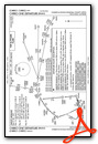
Instrument Approach Procedure (IAP) Charts
Departure Procedure (DP) Charts

Nearby Airports with Instrument Procedures
| ID | Name | Heading / Distance | ||
|---|---|---|---|---|
 |
O69 | Petaluma Municipal Airport | 146° | 18.0 |
|
O60 | Cloverdale Municipal Airport | 332° | 18.1 |
|
KDVO | Gnoss Field Airport | 151° | 25.0 |
|
1O2 | Lampson Field Airport | 351° | 29.1 |
|
KAPC | Napa County Airport | 125° | 30.8 |
|
KVCB | Nut Tree Airport | 100° | 40.9 |
|
KUKI | Ukiah Municipal Airport | 333° | 41.2 |
|
KSUU | Travis AFB Airport | 109° | 44.4 |
|
KDWA | Yolo County Airport | 084° | 45.2 |
|
O41 | Watts-Woodland Airport | 077° | 45.3 |
|
KCCR | Buchanan Field Airport | 130° | 47.4 |
|
KEDU | University Airport | 088° | 48.4 |


