Login
Register


SUE
Door County Cherryland Airport
Official FAA Data Effective 2024-04-18 0901Z
Chart Supplement

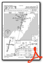
VFR Chart of KSUE
Sectional Charts at SkyVector.com
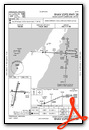
IFR Chart of KSUE
Enroute Charts at SkyVector.com
Location Information for KSUE
Coordinates: N44°50.62' / W87°25.29'Located 02 miles W of Sturgeon Bay, Wisconsin on 436 acres of land. View all Airports in Wisconsin.
Surveyed Elevation is 724 feet MSL.
Operations Data
|
|
Airport Communications
| AWOS-3PT: | 128.325 Tel. 920-743-7087 |
|---|---|
| GREEN BAY APPROACH: | 119.25 338.2 |
| GREEN BAY DEPARTURE: | 119.25 338.2 |
| UNICOM: | 122.700 |
| CTAF: | 122.700 |
| AWOS-3PT at MNM (19.3 NW): | 121.45 906-863-8801 |
| AWOS-3PT at 3D2 (20.1 NE): | 124.175 920-854-5559 |
| AWOS-3 at OCQ (20.8 W): | 120.925 920-835-1599 |
- APCH/DEP SVC PRVDD BY MINNEAPOLIS ARTCC ON 125.55/370.9 (GREEN BAY RCAG) WHEN GREEN BAY APCH CLSD.
Nearby Navigation Aids
|
| ||||||||||||||||||||||||||||||||||||||||||||||||||||||||||||


Runway 02/20
| Dimensions: | 4599 x 75 feet / 1402 x 23 meters | |
|---|---|---|
| Surface: | Asphalt in Fair Condition | |
| Weight Limits: | S-16, D-22 | |
| Edge Lighting: | Medium Intensity | |
| Runway 02 | Runway 20 | |
| Coordinates: | N44°50.22' / W87°25.48' | N44°50.95' / W87°25.25' |
| Elevation: | 721.6 | 704.0 |
| Traffic Pattern: | Left | Left |
| Runway Heading: | 13° True | 193° True |
| Markings: | Non-Precision Instrument in fair condition. | Non-Precision Instrument in fair condition. |
| Glide Slope Indicator | P4L (3.00° Glide Path Angle) | P4L (3.00° Glide Path Angle) |
| Approach Lights: | RLLS RLLS | |
| REIL: | Yes | Yes |
Runway 10/28
| Dimensions: | 3199 x 75 feet / 975 x 23 meters | |
|---|---|---|
| Surface: | Asphalt in Excellent Condition | |
| Weight Limits: | S-16, D-22 | |
| Edge Lighting: | Medium Intensity | |
| Runway 10 | Runway 28 | |
| Coordinates: | N44°50.68' / W87°25.56' | N44°50.66' / W87°24.82' |
| Elevation: | 719.2 | 715.5 |
| Traffic Pattern: | Left | Left |
| Runway Heading: | 93° True | 273° True |
| Markings: | Non-Precision Instrument in good condition. | Non-Precision Instrument in good condition. |
| Glide Slope Indicator | P4L (3.00° Glide Path Angle) | P4L (3.00° Glide Path Angle) |
| REIL: | Yes | Yes |
Services Available
| Fuel: | 100LL (blue), Jet A+ |
|---|---|
| Transient Storage: | Hangars,Tiedowns |
| Airframe Repair: | MINOR |
| Engine Repair: | MINOR |
| Bottled Oxygen: | NOT AVAILABLE |
| Bulk Oxygen: | NOT AVAILABLE |
| Other Services: | CHARTER SERVICE,PILOT INSTRUCTION,AIRCRAFT RENTAL |
Ownership Information
| Ownership: | Publicly owned | |
|---|---|---|
| Owner: | DOOR COUNTY | |
| COURTHOUSE | ||
| STURGEON BAY, WI 54235 | ||
| 920-743-5511 | ||
| Manager: | CRAIG ROSS | |
| 3538 PARK DR DOOR CO ARPT | ||
| STURGEON BAY, WI 54235 | ||
| (920) 746-7131 | ||
Operational Statistics
| Single Engine Aircraft Based on Field: | 39 | Statistics collected for 12 month period ending 2021-09-14 | |
|---|---|---|---|
| Multi-Engine Aircraft Based on Field: | 4 | Annual Commercial Operations: | none |
| Jet Aircraft Based on Field: | 1 | Annual Commuter Operations: | none |
| Helicopters Based on Field: | 1 | Annual Air Taxi Operations: | 500 |
| Military Aircraft Based on Field: | none | Annual Military Operations: | 150 |
| Gliders Based on Field: | none | Annual GA Local Operations: | 10000 |
| Ultralights Based on Field: | none | Annual GA Itinerant Operations: | 12500 |
Other Remarks
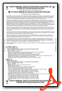
- BE ALERT: NO LINE OF SIGHT RY 02 TO 20.
- GROUP OF FIVE TWRS APRXLY 4 NM NE-TALLEST TWR IS 1351 FT MSL/499 FT AGL.
- DEER, TURKEYS & SEAGULLS OCNL ON ARPT.
- ULTRALIGHT ACTIVITY ON & INVOF ARPT.
- COYOTE OCNLY ON ARPT
- FOR CD CTC GREEN BAY APCH ON FREQ OR 920-431-5741, WHEN APCH CLSD, CTC MINNEAPOLIS ARTCC AT 651-463-5588.
- 0LL 24 HR FUEL AVBL WITH CREDIT CARD.
- ACTVT RLLS RY 02; REIL RY 02/20; PAPI RY 02/20; MIRL RY 02/20; REIL RY 10/28; PAPI RY 10/28; MIRL RY 10/28 - CTAF.
Weather Minimums
Instrument Approach Procedure (IAP) Charts
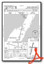
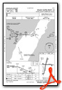
Nearby Airports with Instrument Procedures
| ID | Name | Heading / Distance | ||
|---|---|---|---|---|
 |
KMNM | Menominee Regional Airport | 331° | 19.3 |
|
3D2 | Ephraim/Gibraltar Airport | 029° | 20.1 |
|
KOCQ | Oconto/J Douglas Bake Municipal Airport | 275° | 20.9 |
|
KGRB | Green Bay/Austin Straubel International Airport | 234° | 37.2 |
|
2P2 | Washington Island Airport | 032° | 38.9 |
|
KMTW | Manitowoc County Airport | 194° | 44.3 |
|
KEZS | Shawano Municipal Airport | 266° | 48.7 |
|
KFKS | Frankfort Dow Memorial Field Airport | 103° | 53.8 |
|
KESC | Delta County Airport | 014° | 54.5 |
|
KCLI | Clintonville Municipal Airport | 256° | 57.7 |
|
KATW | Appleton International Airport | 233° | 58.8 |
|
KMBL | Manistee County/Blacker Airport | 123° | 60.9 |
Airport Images
Do you have a recent image of this airport? Upload it here!


