Login
Register


SUW
Richard I Bong Airport
Official FAA Data Effective 2024-04-18 0901Z
Chart Supplement

VFR Chart of KSUW
Sectional Charts at SkyVector.com
IFR Chart of KSUW
Enroute Charts at SkyVector.com
Location Information for KSUW
Coordinates: N46°41.38' / W92°5.68'Located 03 miles S of Superior, Wisconsin on 654 acres of land. View all Airports in Wisconsin.
Surveyed Elevation is 674 feet MSL.
Operations Data
|
|
Airport Communications
| AWOS-3: | 120.35 Tel. 715-394-0283 |
|---|---|
| DULUTH APPROACH: | 125.45 233.7 |
| DULUTH DEPARTURE: | 125.45 233.7 |
| CLEARANCE DELIVERY: | 124.8 |
| UNICOM: | 122.700 |
| CTAF: | 122.700 |
| AWOS-3 at DYT (2.8 NE): | 119.275 218-720-4886 |
| ATIS at DLH (10.0 NW): | 124.1 |
| ASOS at DLH (10.0 NW): | 218-740-5977 |
Nearby Navigation Aids
|
| ||||||||||||||||||||||||||||||||||||||||||||||||


Runway 04/22
| Dimensions: | 5100 x 75 feet / 1554 x 23 meters | |
|---|---|---|
| Surface: | Asphalt in Fair Condition | |
| Edge Lighting: | Medium Intensity | |
| Runway 04 | Runway 22 | |
| Coordinates: | N46°41.35' / W92°6.02' | N46°42.02' / W92°5.29' |
| Elevation: | 670.3 | 659.6 |
| Runway Heading: | 37° True | 217° True |
| Markings: | Non-Precision Instrument in good condition. | Non-Precision Instrument in good condition. |
| Glide Slope Indicator | P4L (3.00° Glide Path Angle) | |
| REIL: | Yes | |
Runway 14/32
| Dimensions: | 4001 x 75 feet / 1220 x 23 meters | |
|---|---|---|
| Surface: | Asphalt in Good Condition | |
| Edge Lighting: | Medium Intensity | |
| Runway 14 | Runway 32 | |
| Coordinates: | N46°41.25' / W92°6.02' | N46°40.74' / W92°5.41' |
| Elevation: | 672.1 | 672.7 |
| Traffic Pattern: | Left | Left |
| Runway Heading: | 140° True | 320° True |
| Markings: | Non-Precision Instrument in good condition. | Non-Precision Instrument in good condition. |
| Glide Slope Indicator | P4L (4.00° Glide Path Angle) | |
| REIL: | Yes | Yes |
Services Available
| Fuel: | 100LL (blue), Jet-A |
|---|---|
| Transient Storage: | Hangars,Tiedowns |
| Airframe Repair: | MAJOR |
| Engine Repair: | MAJOR |
| Bottled Oxygen: | NONE |
| Bulk Oxygen: | NONE |
| Other Services: | PILOT INSTRUCTION,PARACHUTE JUMP ACTIVITY,AIRCRAFT RENTAL |
Ownership Information
| Ownership: | Publicly owned | |
|---|---|---|
| Owner: | CITY OF SUPERIOR | |
| 1316 N. 14TH ST | ||
| SUPERIOR, WI 54880 | ||
| 715-395-7200 | ||
| Manager: | WILLIAM AMORDE | |
| 4804 HAMMOND AVE | ||
| SUPERIOR, WI 54880 | ||
| 715-394-0282 | ||
Operational Statistics
| Single Engine Aircraft Based on Field: | 38 | Statistics collected for 12 month period ending 2022-08-24 | |
|---|---|---|---|
| Multi-Engine Aircraft Based on Field: | 8 | Annual Commercial Operations: | none |
| Jet Aircraft Based on Field: | none | Annual Commuter Operations: | none |
| Helicopters Based on Field: | none | Annual Air Taxi Operations: | 700 |
| Military Aircraft Based on Field: | none | Annual Military Operations: | 50 |
| Gliders Based on Field: | none | Annual GA Local Operations: | 9000 |
| Ultralights Based on Field: | none | Annual GA Itinerant Operations: | 9500 |
Other Remarks
- DEER ON & VICINITY OF ARPT.
- FOR CD CTC DULUTH APCH AT 218-740-5950.
- 0LL 24 HR FUEL AVBL WITH CREDIT CARD.
- ACTVT REIL RWY 04, 14, & 32 - CTAF. MIRL RWY 04/22 & RWY 14/32 PRESET TO LOW SS-SR, TO INCR INTST & ACTVT - CTAF.
Weather Minimums
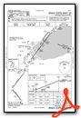
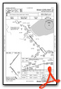
Instrument Approach Procedure (IAP) Charts
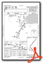
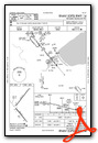
Nearby Airports with Instrument Procedures
| ID | Name | Heading / Distance | ||
|---|---|---|---|---|
 |
KDYT | Sky Harbor Airport | 046° | 2.8 |
|
KDLH | Duluth International Airport | 336° | 10.0 |
|
KCOQ | Cloquet/Carlton County Airport | 272° | 16.9 |
|
KOLG | Solon Springs Municipal Airport | 152° | 25.3 |
|
KTWM | Richard B Helgeson Airport | 033° | 25.9 |
|
KMZH | Moose Lake Carlton County Airport | 241° | 33.6 |
|
3CU | Cable Union Airport | 129° | 46.0 |
|
KEVM | Eveleth/Virginia Municipal Airport | 339° | 47.1 |
|
KHYR | Sawyer County Airport | 145° | 48.2 |
|
KASX | John F Kennedy Memorial Airport | 099° | 49.4 |
|
KHZX | Isedor Iverson Airport | 265° | 50.4 |
|
KHIB | Range Regional Airport | 324° | 51.8 |
Fuel Providers

Airport Images

By: m3chichi


