Login
Register


T00
Chambers County Airport
Official FAA Data Effective 2024-04-18 0901Z
Chart Supplement

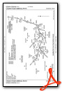
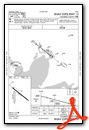
VFR Chart of T00
Sectional Charts at SkyVector.com
IFR Chart of T00
Enroute Charts at SkyVector.com
Location Information for T00
Coordinates: N29°46.19' / W94°39.81'Located 01 miles E of Anahuac, Texas on 216 acres of land. View all Airports in Texas.
Surveyed Elevation is 21 feet MSL.
Operations Data
|
|
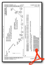
Airport Communications
| HOUSTON APPROACH: | 134.45 284.0 |
|---|---|
| HOUSTON DEPARTURE: | 134.45 284.0 |
| KARRR RNAV DP: | 134.45 |
| INDIE RNAV DP: | 134.45 284.0 |
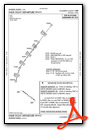
| HUDZY STAR: | 120.05 379.1 |
| HOODO RNAV DP: | 134.45 284.0 |
| PALACIOS DP: | 134.45 284.0 |
| WYLSN RNAV DP: | 134.45 284.0 |
| LURIC DP: | 134.45 |
| STRYA DP: | 134.45 284.0 |
| CTAF: | 122.900 |
| TSHIRT STAR: | 119.175 |
| OHIIO STAR: | 120.05 379.1 |
| WYLSN DP: | 284.0 |
| KARRR DP: | 284.0 |
| MMALT RNAV DP: | 134.45 284.0 |
| DREMR DP: | 134.45 284.0 |
| STYCK DP: | 134.45 284.0 |
| WAPPL STAR: | 120.05 379.1 |
| CESAN STAR: | 121.3 377.1 |
| LURIC RNAV DP: | 284.0 |
| BORRN RNAV DP: | 134.45 284.0 |
| WATFO DP: | 134.45 284.0 |
| TSHRT STAR: | 119.175 291.675 |
| BLUBELL STAR: | 124.225 306.975 |
| TKNIQ STAR: | 119.625 226.675 |
| BLTWY RNAV DP: | 134.45 284.0 |
| AWOS-3PT at T78 (18.4 N): | 120.775 936-587-4150 |
| AWOS-3PT at T41 (21.7 W): | 120.275 281-471-2206 |
| ATIS at EFD (27.6 W): | 269.9 |
Nearby Navigation Aids
|
| ||||||||||||||||||||||||||||||||||||||||||||||||||||||||||||


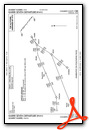
Runway 12/30
| Dimensions: | 3005 x 60 feet / 916 x 18 meters | |
|---|---|---|
| Surface: | Asphalt in Fair Condition | |
| Weight Limits: | S-13 | |
| Edge Lighting: | Medium Intensity | |
| Runway 12 | Runway 30 | |
| Coordinates: | N29°46.36' / W94°39.97' | N29°46.05' / W94°39.52' |
| Elevation: | 20.4 | 20.4 |
| Traffic Pattern: | Left | Right |
| Runway Heading: | 129° True | 309° True |
| Markings: | Non-Precision Instrument in good condition. | Non-Precision Instrument in good condition. |
| Glide Slope Indicator | P2L (4.00° Glide Path Angle) | |
| Obstacles: | 45 ft Pole 882 ft from runway, 160 ft left of center | 15 ft Road 530 ft from runway, 280 ft left of center |
Runway 17/35
| Dimensions: | 1900 x 300 feet / 579 x 91 meters | |
|---|---|---|
| Surface: | Turf in Good Condition | |
| Runway 17 | Runway 35 | |
| Coordinates: | N29°46.31' / W94°39.91' | N29°46.00' / W94°39.91' |
| Elevation: | 20.0 | 20.0 |
| Traffic Pattern: | Left | Right |
| Runway Heading: | 180° True | 0 |
| Markings: | None in good condition. | None in good condition. |
| Obstacles: | 60 ft Trees 890 ft from runway, 90 ft left of center | 17 ft Road 230 ft from runway |
Services Available
| Fuel: | 100LL (blue), Jet-A, Jet A-1+ |
|---|---|
| Transient Storage: | Tiedowns |
| Airframe Repair: | NOT AVAILABLE |
| Engine Repair: | NOT AVAILABLE |
| Bottled Oxygen: | NONE |
| Bulk Oxygen: | NONE |
| Other Services: | CROP DUSTING SERVICES |
Ownership Information
| Ownership: | Publicly owned | |
|---|---|---|
| Owner: | CHAMBERS COUNTY | |
| PO BOX 938 | ||
| ANAHUAC, TX 77514 | ||
| 409-267-2400 | ||
| Manager: | RONNIE BROWN | |
| PO BOX 938 | ||
| ANAHUAC, TX 77514 | ||
| 409-267-2719 | ||
Operational Statistics
| Single Engine Aircraft Based on Field: | 8 | Statistics collected for 12 month period ending 2023-04-04 | |
|---|---|---|---|
| Multi-Engine Aircraft Based on Field: | 1 | Annual Commercial Operations: | none |
| Jet Aircraft Based on Field: | none | Annual Commuter Operations: | none |
| Helicopters Based on Field: | 11 | Annual Air Taxi Operations: | none |
| Military Aircraft Based on Field: | none | Annual Military Operations: | none |
| Gliders Based on Field: | none | Annual GA Local Operations: | 1600 |
| Ultralights Based on Field: | none | Annual GA Itinerant Operations: | 800 |
Other Remarks
- RWY 17/35 SOFT WHEN WET.
- RWY 17, PAPI RWY 12 IN RWY 17 APCH, DO NOT LAND BFR XNG RWY 12.
- FOR CD CTC HOUSTON APCH AT 281-443-5844 TO CNL IFR CALL 281-443-5888.
- 0LL FUEL 24 HR SELF-SERVE.
- DUSK-DAWN. MIRL RWY 12/30 PRESET LOW INTST; TO INCR INTST ACTVT - CTAF.
Weather Minimums
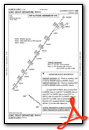
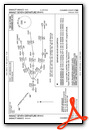
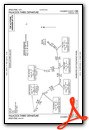
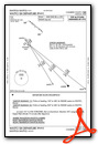
Standard Terminal Arrival (STAR) Charts

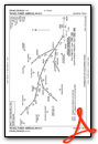
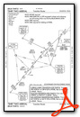
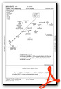
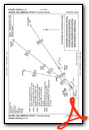
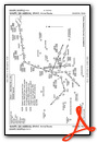
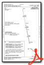
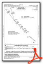
Instrument Approach Procedure (IAP) Charts
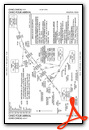
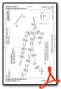
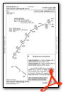
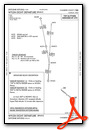
Departure Procedure (DP) Charts

Nearby Airports with Instrument Procedures
| ID | Name | Heading / Distance | ||
|---|---|---|---|---|
 |
54T | Rwj Airpark Airport | 267° | 9.6 |
|
T90 | Chambers County/Winnie Stowell Airport | 076° | 12.5 |
|
KHPY | Baytown Airport | 273° | 15.1 |
|
T78 | Liberty Municipal Airport | 354° | 18.5 |
|
T41 | La Porte Municipal Airport | 254° | 21.8 |
|
KEFD | Ellington Airport | 249° | 27.6 |
|
KBMT | Beaumont Municipal Airport | 052° | 29.5 |
|
KGLS | Scholes International At Galveston Airport | 198° | 31.9 |
|
KHOU | William P Hobby Airport | 257° | 32.9 |
|
KLVJ | Pearland Regional Airport | 243° | 33.7 |
|
KBPT | Jack Brooks Regional Airport | 071° | 35.2 |
|
KIAH | George Bush Intcntl/Houston Airport | 290° | 37.6 |
Airport Images
Do you have a recent image of this airport? Upload it here!


