Login
Register


TBN
Waynesville-St Robert Regional Forney Field Airport
Official FAA Data Effective 2024-03-21 0901Z
Chart Supplement

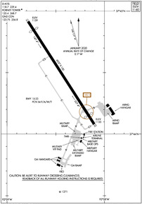
KTBN Airport Diagram
VFR Chart of KTBN
Sectional Charts at SkyVector.com
IFR Chart of KTBN
Enroute Charts at SkyVector.com
Location Information for KTBN
Coordinates: N37°44.50' / W92°8.44'Located 00 miles SW of Fort Leonard Wood, Missouri on 237 acres of land. View all Airports in Missouri.
Surveyed Elevation is 1159 feet MSL.
Operations Data
|
|
Airport Communications
| D-ATIS: | 118.7 229.4 |
|---|---|
| ASOS: | 118.7 |
| FORNEY TOWER: | 125.4 268.7 |
| FORNEY GROUND: | 123.75 256.8 |
| CTAF: | 125.400 |
| ARNG OPS: | 140.2 245.7 32.125 |
| EMERG: | 121.5 243.0 |
| OPS: | 122.95 ;FORNEY OPS 237.5 ;FORNEY OPS |
| AWOS-3PT at LBO (25.1 W): | 118.975 417-533-3419 |
| AWOS-3PT at AIZ (28.8 NW): | 135.325 573-348-0847 |
| ASOS at VIH (29.1 NE): | 119.025 573-299-4419 |
- APCH/DEP SVC PRVDD BY KANSAS CITY ARTCC ON FREQS 128.35/284.675 (RICHLAND RCAG).
Nearby Navigation Aids
|
| ||||||||||||||||||||||||||||||||||||||||||||||||||||||


Runway 15/33
| Dimensions: | 6037 x 150 feet / 1840 x 46 meters | |
|---|---|---|
| Surface: | Asphalt in Good Condition | |
| Weight Limits: | 54 /F/A/W/T | |
| Edge Lighting: | High Intensity | |
| Runway 15 | Runway 33 | |
| Coordinates: | N37°44.92' / W92°8.78' | N37°44.08' / W92°8.10' |
| Elevation: | 1159.4 | 1154.9 |
| Traffic Pattern: | Right | |
| Runway Heading: | 147° True | 327° True |
| Displaced Threshold: | 502 Feet | 527 Feet |
| Markings: | Precision Instrument in good condition. | Precision Instrument in good condition. |
| Glide Slope Indicator | P4L (3.00° Glide Path Angle) PAPI UNUSBL BYD 8 DEGS LEFT OF CNTRLN. | P4R (3.00° Glide Path Angle) PAPI UNUSBL BYD 8 DEGS LEFT AND 8 DEGS RIGHT OF CNTRLN. |
| RVR Equipment | Rollout | Touchdown |
| Approach Lights: | MALSR 1,400 Foot Medium-intensity Approach Lighting System with runway alignment indicator lights. | MALS 1,400 Foot Medium-intensity Approach Lighting System. |
| REIL: | Yes | Yes |
| Obstacles: | 9 ft Pole 210 ft from runway, 450 ft left of center 50:1 TO DSPLCD THR. |
17 ft Road 450 ft from runway 50:1 TO DSPLCD THR. +15' GND AT 200'; 200-500' R CTRLN; OBST LIGHTED FENCE. |
Services Available
| Fuel: | 100LL (blue), Jet-A |
|---|---|
| Transient Storage: | Hangars,Tiedowns |
| Airframe Repair: | NONE |
| Engine Repair: | NONE |
| Bottled Oxygen: | NONE |
| Bulk Oxygen: | NONE |
Ownership Information
| Ownership: | Owned by the Army | |
|---|---|---|
| Owner: | U S ARMY | |
| FORNEY ARMY AIRFIELD | ||
| FT LEONARD WOOD, MO 65473 | ||
| 573-596-0165 | ||
| Manager: | MIKE GUY | AIRPORT MANAGER (CIVIL) MIKE GUY 573-329-4216 |
| FORNEY ARMY AIRFIELD | ||
| FT LEONARD WOOD, MO 65473 | ||
| 573-596-0165 | ||
Operational Statistics
| Single Engine Aircraft Based on Field: | 9 | Statistics collected for 12 month period ending 2021-12-31 | |
|---|---|---|---|
| Multi-Engine Aircraft Based on Field: | none | Annual Commercial Operations: | 888 |
| Jet Aircraft Based on Field: | none | Annual Commuter Operations: | none |
| Helicopters Based on Field: | none | Annual Air Taxi Operations: | none |
| Military Aircraft Based on Field: | 11 | Annual Military Operations: | 7906 |
| Gliders Based on Field: | none | Annual GA Local Operations: | 2604 |
| Ultralights Based on Field: | none | Annual GA Itinerant Operations: | 2063 |
Other Remarks
- RSTD: PPR FOR ALL TRAN MIL ACFT DSN 581-0165/4819; C573-596-0165/4819.
- SFC VSBY LIMITED BY TREE LINE FM E TO S TO W.
- WX SVC AVBL MON-FRI EXC HOL 1300-0400Z++. AN/FMQ-19 AUTOMATED OBSERVING SYS IN USE; AUGMENTED BY HUMAN OBSN WHEN NEC DUR AFLD HRS. OT REMOTE BRIEFING SVC AVBL 26 OWS BARKSDALE AFB DSN 781-4775, C318-456-4775, C866-223-2398 (TOLL FREE).
- MILITARY SERVICE: NO MIL FUEL AVBL. CIV: NC A AVBL 1400-2300Z++ OT C573-329-4216. 100LL AVBL H24 WITH CREDIT CARD.
- MILITARY: SVC: SOUTH END OF RWY SAFETY ZONE UNPROTECTED WHEN TWR CLSD.
- WHEN ATCT CLSD, FOR CD CTC KANSAS CITY ARTCC AT 913-254-8508.
- RSTD: CIV FBO RAMP CLSD TO MIL ACFT.
- WHEN TWR CLSD ACTVT MALS RWY 33; MALSR RWY 15; REIL RWY 15 & 33; PAPI RWY 15 & 33; HIRL RWY 15/33 - CTAF.
Weather Minimums
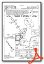
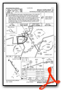
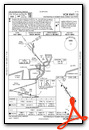
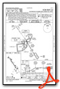
Instrument Approach Procedure (IAP) Charts
Nearby Airports with Instrument Procedures
| ID | Name | Heading / Distance | ||
|---|---|---|---|---|
 |
KLBO | Floyd W Jones Lebanon Airport | 257° | 25.0 |
|
M48 | Houston Memorial Airport | 161° | 25.9 |
|
K33 | Salem Memorial Airport | 106° | 26.6 |
|
KAIZ | Lee C Fine Memorial Airport | 317° | 28.8 |
|
KVIH | Rolla Ntl Airport | 037° | 29.1 |
|
KOZS | Camdenton Memorial-Lake Regional Airport | 298° | 29.6 |
|
K15 | Grand Glaize-Osage Beach Airport | 310° | 33.8 |
|
KTVB | Cabool Memorial Airport | 175° | 36.6 |
|
1MO | Mountain Grove Memorial Airport | 192° | 38.1 |
|
KUBX | Cuba Municipal Airport | 059° | 39.1 |
|
H79 | Eldon Model Airpark Airport | 331° | 42.4 |
|
KMNF | Mountain View Airport | 155° | 49.3 |
Airport Images
Do you have a recent image of this airport? Upload it here!


