Login
Register


TCS
Truth Or Consequences Municipal Airport
Official FAA Data Effective 2024-04-18 0901Z
Chart Supplement

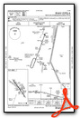
VFR Chart of KTCS
Sectional Charts at SkyVector.com
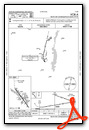
IFR Chart of KTCS
Enroute Charts at SkyVector.com
Location Information for KTCS
Coordinates: N33°14.12' / W107°16.19'Located 06 miles N of Truth Or Consequences, New Mexico on 950 acres of land. View all Airports in New Mexico.
Surveyed Elevation is 4861 feet MSL.
Operations Data
|
|
Airport Communications
| ASOS: | 120.675 Tel. 575-894-2909 |
|---|---|
| UNICOM: | 122.800 |
| CTAF: | 122.800 |
| AWOS-3PT at 0A0 (21.2 SE): | 118.675 575-267-8806 |
| AWOS-3 at ONM (50.7 N): | 118.325 575-838-3993 |
| AWOS-3 at SVC (57.3 SW): | 126.725 575-388-5947 |
- APCH/DEP SVC PRVDD BY ALBUQUERQUE ARTCC (ZAB) ON FREQS 128.2/285.5 (TRUTH OR CONSEQUENCES RCAG).
Nearby Navigation Aids
|
| ||||||||||||||||||||||||||||||||||||||||||


Runway 13/31
| Dimensions: | 7202 x 75 feet / 2195 x 23 meters | |
|---|---|---|
| Surface: | Asphalt in Good Condition | |
| Weight Limits: | 15 /F/C/X/T, S-410, D-59 | |
| Edge Lighting: | Medium Intensity | |
| Runway 13 | Runway 31 | |
| Coordinates: | N33°14.59' / W107°16.62' | N33°13.63' / W107°15.80' |
| Elevation: | 4852.6 | 4794.1 |
| Traffic Pattern: | Left | Left |
| Runway Heading: | 145° True | 325° True |
| Markings: | Non-Precision Instrument in good condition. | Non-Precision Instrument in good condition. |
| Glide Slope Indicator | P2L (3.00° Glide Path Angle) | P2L (3.00° Glide Path Angle) |
Runway 11/29
2-4 FT BRUSH 100 FT BOTH SIDES E 500 FT. | ||
| Dimensions: | 6981 x 190 feet / 2128 x 58 meters | |
|---|---|---|
| Surface: | Gravel in Good Condition | |
| Runway 11 | Runway 29 | |
| Coordinates: | N33°14.55' / W107°16.88' | N33°13.88' / W107°15.76' |
| Elevation: | 4861.9 | 4799.3 |
| Runway Heading: | 125° True | 305° True |
| Obstacles: | 8 ft Brush 2 ft from runway CTLG OBSTN EXCEEDS 45 DEG SLOPE. |
6 ft Brush 0 ft from runway |
Runway 01/19
2-4 FT BRUSH 75 FT BOTH SIDES W 1800 FT. | ||
| Dimensions: | 3302 x 130 feet / 1006 x 40 meters | |
|---|---|---|
| Surface: | Gravel in Good Condition SFC HAS SCATTERED LRG ROCKS. | |
| Runway 01 | Runway 19 | |
| Coordinates: | N33°13.79' / W107°16.23' | N33°14.30' / W107°15.99' |
| Elevation: | 4812.5 | 4818.0 |
| Traffic Pattern: | Left | Left |
| Runway Heading: | 21° True | 201° True |
| Obstacles: | 15 ft Road 90 ft from runway | |
Runway 15/33
| Dimensions: | 3001 x 140 feet / 915 x 43 meters | |
|---|---|---|
| Surface: | Gravel in Good Condition | |
| Runway 15 | Runway 33 | |
| Coordinates: | N33°14.30' / W107°16.05' | N33°13.82' / W107°15.92' |
| Elevation: | 4821.0 | 4802.9 |
| Traffic Pattern: | Left | Left |
| Runway Heading: | 167° True | 347° True |
| Obstacles: | 15 ft Road 45 ft from runway | |
Runway 07/25
| Dimensions: | 2933 x 130 feet / 894 x 40 meters | |
|---|---|---|
| Surface: | Gravel in Good Condition +1 FT BRUSH & ROUGH AREAS. | |
| Runway 07 | Runway 25 | |
| Coordinates: | N33°14.02' / W107°16.44' | N33°14.12' / W107°15.88' |
| Elevation: | 4828.5 | 4808.7 |
| Traffic Pattern: | Left | Left |
| Runway Heading: | 79° True | 259° True |
| Obstacles: | CTLG OBSTN EXCEEDS 45 DEG SLOPE. |
10 ft Road 0 ft from runway |
Services Available
| Fuel: | 100LL (blue), Jet A-1+ |
|---|---|
| Transient Storage: | Hangars,Tiedowns AVBLTY - AMGR. |
| Airframe Repair: | NOT AVAILABLE |
| Engine Repair: | NOT AVAILABLE |
| Bottled Oxygen: | NOT AVAILABLE |
| Bulk Oxygen: | NOT AVAILABLE |
Ownership Information
| Ownership: | Publicly owned | |
|---|---|---|
| Owner: | CITY OF TRUTH OR CONSEQUENCES | |
| 505 SIMS | ||
| TRUTH OR CONSEQUENCE, NM 87901 | ||
| 575-894-6673 | ||
| Manager: | CHAD ROSACKER | |
| 505 SIMS | ||
| TRUTH OR CONSEQUENCE, NM 87901 | ||
| 575-894-6199 | ||
Operational Statistics
| Single Engine Aircraft Based on Field: | 23 | Statistics collected for 12 month period ending 2023-04-07 | |
|---|---|---|---|
| Multi-Engine Aircraft Based on Field: | 1 | Annual Commercial Operations: | none |
| Jet Aircraft Based on Field: | none | Annual Commuter Operations: | none |
| Helicopters Based on Field: | none | Annual Air Taxi Operations: | none |
| Military Aircraft Based on Field: | none | Annual Military Operations: | 1200 |
| Gliders Based on Field: | none | Annual GA Local Operations: | 4500 |
| Ultralights Based on Field: | none | Annual GA Itinerant Operations: | 10000 |
Other Remarks
- OPS BTW RWYS NOT VSB DUE TO BRUSH.
- ULTRALIGHT OPS WI 5 NM.
- +1-2 FT GRAVEL BERMS ALG EDGE OF GRAVEL RWYS. GRAVEL RWYS MRKGS & SIGNS NA.
- FOR CD IF UNA TO CTC ON FSS FREQ, CTC ALBUQUERQUE ARTCC AT 505-856-4561.
- FUEL AFT HR - AMGR.
- SHARP DROP OFFS APCH END.
- SHARP DROP OFFS APCH END.
- DUSK-DAWN: ACTVT MIRL RWY 13/31 - CTAF.
Weather Minimums
Instrument Approach Procedure (IAP) Charts
Nearby Airports with Instrument Procedures
| ID | Name | Heading / Distance | ||
|---|---|---|---|---|
 |
KONM | Socorro Municipal Airport | 021° | 50.6 |
|
KSVC | Grant County Airport | 231° | 57.4 |
|
KLRU | Las Cruces International Airport | 162° | 59.3 |
|
KDMN | Deming Municipal Airport | 201° | 62.5 |
|
KHMN | Holloman AFB Airport | 111° | 62.9 |
|
KALM | Alamogordo-White Sands Regional Airport | 109° | 68.7 |
|
KDNA | Dona Ana County International Jetport Airport | 160° | 86.1 |
|
KBRG | Belen Regional Airport | 014° | 87.2 |
|
KSRR | Sierra Blanca Regional Airport | 080° | 88.5 |
|
KELP | El Paso International Airport | 151° | 96.8 |
|
KCFT | Greenlee County Airport | 260° | 99.3 |
|
KABQ | Albuquerque International Sunport Airport | 016° | 112.9 |
Airport Images
Do you have a recent image of this airport? Upload it here!


