Login
Register


THV
York Airport
Official FAA Data Effective 2024-04-18 0901Z
Chart Supplement

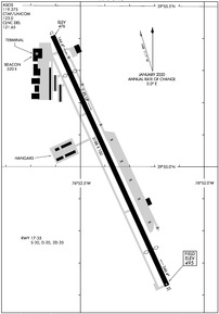
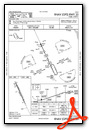
KTHV Airport Diagram
VFR Chart of KTHV
Sectional Charts at SkyVector.com
IFR Chart of KTHV
Enroute Charts at SkyVector.com
Location Information for KTHV
Coordinates: N39°55.02' / W76°52.38'Located 07 miles SW of York, Pennsylvania on 66 acres of land. View all Airports in Pennsylvania.
Surveyed Elevation is 494 feet MSL.
Operations Data
|
|
Airport Communications
| ASOS: | 119.275 Tel. 717-792-5529 |
|---|---|
| HARRISBURG APPROACH: | 124.1 273.525 |
| HARRISBURG DEPARTURE: | 124.1 273.525 |
| CLEARANCE DELIVERY: | 121.65 |
| CTAF: | 123.000 |
| UNICOM: | 123.000 |
| ATIS at MDT (17.3 N): | 118.8 |
| ASOS at MDT (17.4 N): | 717-944-1372 |
| ATIS at CXY (18.0 N): | 134.95 |
Nearby Navigation Aids
|
| ||||||||||||||||||||||||||||||||||||||||||||||||||||||||||||


Runway 17/35
| Dimensions: | 5188 x 100 feet / 1581 x 30 meters | |
|---|---|---|
| Surface: | Asphalt / Grooved in Good Condition | |
| Weight Limits: | S-20, D-20, ST-20 | |
| Edge Lighting: | Medium Intensity | |
| Runway 17 | Runway 35 | |
| Coordinates: | N39°55.41' / W76°52.61' | N39°54.63' / W76°52.15' |
| Elevation: | 475.8 | 494.7 |
| Traffic Pattern: | Left | Left |
| Runway Heading: | 155° True | 335° True |
| Displaced Threshold: | 794 Feet | 739 Feet |
| Markings: | Non-Precision Instrument in good condition. | Non-Precision Instrument in good condition. |
| Glide Slope Indicator | P4L (4.50° Glide Path Angle) | P4L (3.67° Glide Path Angle) |
| REIL: | Yes | Yes |
| Obstacles: | 40 ft Pole 226 ft from runway, 183 ft right of center 20:1 TO DTHR. RWY 17 HAS +15 FT ROAD 10-200 FT FROM RWY END 250 FT LEFT & RIGHT; +15 BLAST FENCE 50-85 FT FROM RWY END MARKED AND LIGHTED. |
43 ft Trees 404 ft from runway, 223 ft left of center RWY 35 APCH SLP 23:1 TO DTHR. |
Services Available
| Fuel: | 100LL (blue), Jet-A |
|---|---|
| Transient Storage: | Hangars,Tiedowns |
| Airframe Repair: | MAJOR |
| Engine Repair: | MAJOR |
| Bottled Oxygen: | HIGH |
| Bulk Oxygen: | NONE |
Ownership Information
| Ownership: | Privately Owned | |
|---|---|---|
| Owner: | YORK BLDG PRODUCTS INC | |
| PO BOX 2587 | ||
| YORK, PA 17405 | ||
| 717-792-5566 | ||
| Manager: | MARK TOMLINSON | |
| 6054 LINCOLN HIGHWAY WEST | ||
| THOMASVILLE, PA 17364 | ||
| 717-792-5566 | ||
Operational Statistics
| Single Engine Aircraft Based on Field: | 44 | Statistics collected for 12 month period ending 2023-12-05 | |
|---|---|---|---|
| Multi-Engine Aircraft Based on Field: | 10 | Annual Commercial Operations: | none |
| Jet Aircraft Based on Field: | 5 | Annual Commuter Operations: | none |
| Helicopters Based on Field: | 3 | Annual Air Taxi Operations: | 1050 |
| Military Aircraft Based on Field: | none | Annual Military Operations: | 300 |
| Gliders Based on Field: | none | Annual GA Local Operations: | 31400 |
| Ultralights Based on Field: | none | Annual GA Itinerant Operations: | 20000 |
Other Remarks
- TREES WI PRIM SFC 83 FT IN FM THLD & 221 FT L OF RWY 17 CNTRLN; RAMP TIE-DOWN AREA, MEDIVAC PARKING PAD & TWY WI PRIM SFC ON R SIDE.
- TWY TO RWY 35 CLSD TO ACFT WITH WINGSPAN OVER 60 FT.
- RWY 17 TREES 1377 FT OUT 88 FT RIGHT APCH SLP 20:1 TO DTHR.
- RWY 35 TREES 2695 FT OUT 426 FT RIGHT APCH SLP 23:1 TO DTHR.
- FOR CD CTC HARRISBURG APCH AT 800-932-0712.
Weather Minimums
Instrument Approach Procedure (IAP) Charts
Nearby Airports with Instrument Procedures
| ID | Name | Heading / Distance | ||
|---|---|---|---|---|
 |
N71 | Donegal Springs Airpark Airport | 052° | 17.3 |
|
KMDT | Harrisburg International Airport | 017° | 17.3 |
|
KCXY | Capital City Airport | 003° | 18.0 |
|
W05 | Gettysburg Regional Airport | 256° | 19.1 |
|
KDMW | Carroll County Regional/Jack B Poage Field Airport | 198° | 19.5 |
|
N94 | Carlisle Airport | 319° | 21.4 |
|
58N | Reigle Field Airport | 031° | 26.0 |
|
2W2 | Clearview Airpark Airport | 193° | 27.8 |
|
KLNS | Lancaster Airport | 065° | 29.4 |
|
08N | Keller Brothers Airport | 047° | 33.6 |
|
N68 | Franklin County Regional Airport | 275° | 35.7 |
|
9D4 | Deck Airport | 043° | 36.1 |
")


