Login
Register


TPF
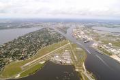
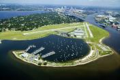
Peter O Knight Airport
Official FAA Data Effective 2024-04-18 0901Z
Chart Supplement

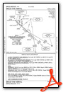
VFR Chart of KTPF
Sectional Charts at SkyVector.com
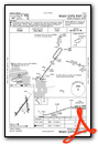
IFR Chart of KTPF
Enroute Charts at SkyVector.com
Location Information for KTPF
Coordinates: N27°54.93' / W82°26.96'Located 03 miles S of Tampa, Florida on 107 acres of land. View all Airports in Florida.
Surveyed Elevation is 7 feet MSL.
Operations Data
|
|
Airport Communications
| AWOS-3: | 118.925 Tel. 813-251-6824 |
|---|---|
| TAMPA APPROACH: | 119.9 290.3 |
| TAMPA DEPARTURE: | 119.9 290.3 |
| CLEARANCE DELIVERY: | 119.8 ;IFR |
| CTAF: | 122.725 |
| UNICOM: | 122.725 |
| ATIS at MCF (5.5 SW): | 270.1 |
| D-ATIS at TPA (5.7 NW): | 128.475 ;DEP |
| ASOS at TPA (6.4 NW): | 126.45 813-873-7228 |
Nearby Navigation Aids
|
| ||||||||||||||||||||||||||||||||||||||||||


Runway 04/22
| Dimensions: | 3583 x 100 feet / 1092 x 30 meters | |
|---|---|---|
| Surface: | Asphalt in Good Condition | |
| Weight Limits: | 26 /F/A/X/T, S-75, D-108 | |
| Edge Lighting: | Medium Intensity | |
| Runway 04 | Runway 22 | |
| Coordinates: | N27°54.65' / W82°27.24' | N27°55.13' / W82°26.84' |
| Elevation: | 6.9 | 6.0 |
| Traffic Pattern: | Right | Left |
| Runway Heading: | 37° True | 217° True |
| Displaced Threshold: | 179 Feet | 180 Feet |
| Declared Distances: | TORA:3403 TODA:3403 ASDA:3403 LDA:3224 | TORA:3404 TODA:3404 ASDA:3404 LDA:3403 |
| Markings: | Non-Precision Instrument in good condition. | Non-Precision Instrument in good condition. |
| Glide Slope Indicator | P4L (3.50° Glide Path Angle) | |
| REIL: | Yes | |
| Obstacles: | 6 ft Fence 200 ft from runway, 222 ft right of center APCH RATIO 28:1 TO DTHR. 6 FT FENCE 200 FT FM RWY END 222 FT R. |
30 ft Boat 415 ft from runway, 170 ft right of center RWY 22 APCH RATIO 26:1 TO THE DTHR. |
Runway 18/36
| Dimensions: | 2687 x 75 feet / 819 x 23 meters | |
|---|---|---|
| Surface: | Asphalt in Fair Condition | |
| Weight Limits: | 8 /F/B/X/T, S-27, D-42 | |
| Edge Lighting: | Medium Intensity | |
| Runway 18 | Runway 36 | |
| Coordinates: | N27°55.20' / W82°26.89' | N27°54.76' / W82°26.83' |
| Elevation: | 5.9 | 6.3 |
| Traffic Pattern: | Left | Right |
| Runway Heading: | 173° True | 353° True |
| Displaced Threshold: | 203 Feet | 201 Feet |
| Declared Distances: | TORA:2687 TODA:2687 ASDA:2574 LDA:2371 | TORA:2487 TODA:2487 ASDA:2512 LDA:2311 |
| Markings: | Non-Precision Instrument in good condition. | Non-Precision Instrument in good condition. |
| Glide Slope Indicator | P2R (3.00° Glide Path Angle) | |
| Obstacles: | 6 ft Fence 200 ft from runway, 93 ft right of center APCH RATIO 20:1 TO DTHR. RWY 18 HAS 6 FT FENCE AND 15 FT ROAD 200 FT FM RWY END 93 FT RIGHT. |
5 ft Fence 200 ft from runway, 150 ft left of center APCH RATIO 25:1 TO DTHR. RWY 36 HAS 5 FT FENCE AND 15 FT ROAD 200 FT FM RWY END 150 FT L. |
Services Available
| Fuel: | 100LL (blue), Jet-A |
|---|---|
| Transient Storage: | Hangars,Tiedowns |
| Airframe Repair: | MAJOR |
| Engine Repair: | MAJOR |
| Bottled Oxygen: | LOW |
| Bulk Oxygen: | HIGH/LOW |
| Other Services: | AVIONICS,CHARTER SERVICE,PILOT INSTRUCTION,AIRCRAFT RENTAL |
Ownership Information
| Ownership: | Publicly owned | |
|---|---|---|
| Owner: | HILLSBOROUGH COUNTY AVIATION AUTH | JOHN TILIACOS |
| PO BOX 22287 | ||
| TAMPA, FL 33622 | ||
| (813) 870-8776 | 813-251-1752 | |
| Manager: | BRETT FAY | |
| PO BOX 22287 | ||
| TAMPA, FL 33606 | ||
| (813) 870-8735 | ||
Operational Statistics
| Single Engine Aircraft Based on Field: | 87 | Statistics collected for 12 month period ending 2017-12-13 | |
|---|---|---|---|
| Multi-Engine Aircraft Based on Field: | 8 | Annual Commercial Operations: | none |
| Jet Aircraft Based on Field: | none | Annual Commuter Operations: | none |
| Helicopters Based on Field: | 5 | Annual Air Taxi Operations: | 3800 |
| Military Aircraft Based on Field: | none | Annual Military Operations: | none |
| Gliders Based on Field: | none | Annual GA Local Operations: | 21000 |
| Ultralights Based on Field: | none | Annual GA Itinerant Operations: | 29000 |
Other Remarks
- OCEAN VESSEL SHIP CHANNEL EAST.
- GULLS ON AND INVOF ARPT.
- TWY E CLSD TO ACFT WITH WING SPANS IN EXCESS OF 40 FT.
- ALERT: MACDILL AFB LCTD 4 MILES SW & HOSP HEL TFC 1 NM NORTH USING UNICOM 122.825.
- FOR CD CTC TAMPA APCH AT 813-878-2528
- SHIP CHANNEL APCH END.
- SHIP CHANNEL APCH END.
- ACTVT REIL RWY 22; PAPI RWY 04 & 36; MIRL RWY 04/22 & 18/36 - CTAF.
Weather Minimums


Standard Terminal Arrival (STAR) Charts
Instrument Approach Procedure (IAP) Charts
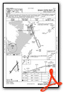
Nearby Airports with Instrument Procedures
| ID | Name | Heading / Distance | ||
|---|---|---|---|---|
 |
KMCF | Macdill AFB Airport | 224° | 5.5 |
|
KTPA | Tampa International Airport | 308° | 5.7 |
|
KVDF | Tampa Exec Airport | 043° | 8.1 |
|
KPIE | St Pete-Clearwater International Airport | 268° | 12.6 |
|
KSPG | Albert Whitted Airport | 226° | 13.0 |
|
KPCM | Plant City Airport | 071° | 16.0 |
|
KCLW | Clearwater Air Park Airport | 282° | 16.9 |
|
KLAL | Lakeland Linder International Airport | 079° | 23.3 |
|
KZPH | Zephyrhills Municipal Airport | 039° | 24.3 |
|
KSRQ | Sarasota/Bradenton International Airport | 190° | 31.6 |
|
KBKV | Brooksville-Tampa Bay Regional Airport | 359° | 33.4 |
|
KBOW | Bartow Exec Airport | 087° | 35.4 |
Airport Images
By: deric@atlasavia...
By: deric@atlasavia...


