Login
Register


TTF
Custer Airport
Official FAA Data Effective 2024-04-18 0901Z
Chart Supplement

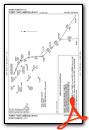
VFR Chart of KTTF
Sectional Charts at SkyVector.com
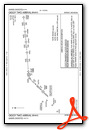
IFR Chart of KTTF
Enroute Charts at SkyVector.com
Location Information for KTTF
Coordinates: N41°56.39' / W83°26.08'Located 02 miles NW of Monroe, Michigan on 158 acres of land. View all Airports in Michigan.
Surveyed Elevation is 615 feet MSL.
Operations Data
|
|
Airport Communications
| AWOS-3: | 119.075 Tel. 734-384-0259 |
|---|---|
| DETROIT APPROACH: | 134.3 284.0 |
| DETROIT DEPARTURE: | 134.3 284.0 |
| UNICOM: | 122.700 |
| CTAF: | 122.700 |
| AWOS-3 at ONZ (15.5 NE): | 119.675 734-692-9686 |
| AWOS-3 at DUH (15.7 SW): | 119.175 734-856-1563 |
| D-ATIS at DTW (16.8 N): | 118.125 ;DEP |
Nearby Navigation Aids
|
| ||||||||||||||||||||||||||||||||||||||||||||||||||||||||||||


Runway 03/21
| Dimensions: | 4997 x 100 feet / 1523 x 30 meters | |
|---|---|---|
| Surface: | Asphalt / Grooved in Good Condition | |
| Weight Limits: | S-60, D-80 | |
| Edge Lighting: | Medium Intensity | |
| Runway 03 | Runway 21 | |
| Coordinates: | N41°56.01' / W83°26.29' | N41°56.77' / W83°25.87' |
| Elevation: | 611.1 | 615.4 |
| Traffic Pattern: | Left | Left |
| Runway Heading: | 22° True | 202° True |
| Markings: | Non-Precision Instrument in good condition. | Non-Precision Instrument in good condition. |
| Glide Slope Indicator | V2L (4.00° Glide Path Angle) | P2L (3.50° Glide Path Angle) |
| REIL: | Yes | |
Services Available
| Fuel: | 100LL (blue), Jet A+ |
|---|---|
| Transient Storage: | Hangars,Tiedowns |
| Airframe Repair: | MAJOR |
| Engine Repair: | MAJOR |
| Bottled Oxygen: | NONE |
| Bulk Oxygen: | NONE |
| Other Services: | PILOT INSTRUCTION,AIRCRAFT RENTAL |
Ownership Information
| Ownership: | Publicly owned | |
|---|---|---|
| Owner: | CITY OF MONROE | |
| 120 E 1ST ST | ||
| MONROE, MI 48161-2283 | ||
| 734-384-9125 | ||
| Manager: | DANIEL DIESING | |
| 2800 N CUSTER RD | ||
| MONROE, MI 48162-3537 | ||
| 734-384-9616 | CELL 734-777-9169. | |
Operational Statistics
| Single Engine Aircraft Based on Field: | 27 | Statistics collected for 12 month period ending 2021-12-31 | |
|---|---|---|---|
| Multi-Engine Aircraft Based on Field: | 3 | Annual Commercial Operations: | none |
| Jet Aircraft Based on Field: | none | Annual Commuter Operations: | none |
| Helicopters Based on Field: | none | Annual Air Taxi Operations: | none |
| Military Aircraft Based on Field: | none | Annual Military Operations: | none |
| Gliders Based on Field: | none | Annual GA Local Operations: | 6000 |
| Ultralights Based on Field: | none | Annual GA Itinerant Operations: | 6000 |
Other Remarks
- THIS AIRPORT HAS BEEN SURVEYED BY THE NATIONAL GEODETIC SURVEY.
- BIRDS & DEER INVOF RWY.
- NOISE SENSITIVE AREAS. DEP ACFT MAX RATE OF CLIMB TO TPA.
- FOR CD CTC DETROIT APCH AT 734-955-1404.
- 0LL 100LL SELF SVC; JET A+ FULL SVC.
- ACTVT VASI RWY 03; PAPI RWY 21; REIL RWY 21; MIRL RWY 03/21 - CTAF.
Weather Minimums
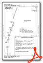
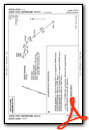
Standard Terminal Arrival (STAR) Charts
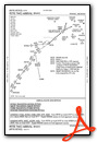
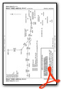
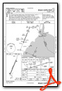
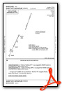
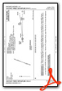
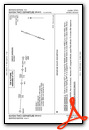
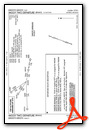
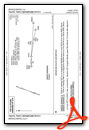
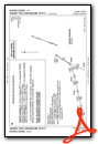
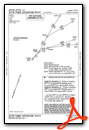
Instrument Approach Procedure (IAP) Charts
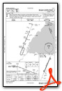
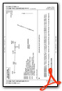
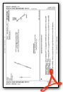
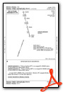
Departure Procedure (DP) Charts
Nearby Airports with Instrument Procedures
| ID | Name | Heading / Distance | ||
|---|---|---|---|---|
 |
KONZ | Grosse Ile Municipal Airport | 051° | 15.5 |
|
KDUH | Toledo Suburban Airport | 219° | 15.7 |
|
KDTW | Detroit Metro Wayne County Airport | 012° | 16.7 |
|
KYIP | Willow Run Airport | 346° | 18.5 |
|
KARB | Ann Arbor Municipal Airport | 320° | 21.9 |
|
KTDZ | Toledo Exec Airport | 185° | 22.6 |
|
1D2 | Canton-Plymouth-Mettetal Airport | 357° | 24.5 |
|
KTOL | Eugene F Kranz Toledo Express Airport | 218° | 27.0 |
|
KADG | Lenawee County Airport | 261° | 29.1 |
|
CYQG | Windsor Airport | 046° | 29.3 |
|
KDET | Coleman A Young Municipal Airport | 033° | 33.9 |
|
1G0 | Wood County Airport | 195° | 34.1 |
Airport Images
Do you have a recent image of this airport? Upload it here!


