Login
Register


TTS
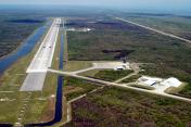
Space Florida Launch and Landing Facility Airport
Official FAA Data Effective 2024-04-18 0901Z
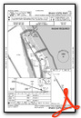
Chart Supplement

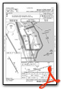
VFR Chart of KTTS
Sectional Charts at SkyVector.com
IFR Chart of KTTS
Enroute Charts at SkyVector.com
Location Information for KTTS
Coordinates: N28°36.89' / W80°41.66'Located 06 miles E of Titusville, Florida on 500 acres of land. View all Airports in Florida.
Surveyed Elevation is 8 feet MSL.
Operations Data
|
|
Airport Communications
| NASA TOWER: | 128.55 284.0 |
|---|---|
| NASA GROUND: | 121.75 |
| ORLANDO APPROACH: | 281.425 134.95 281.425 |
| ORLANDO DEPARTURE: | 281.425 134.95 281.425 |
| PMSV METRO: | 222.05 |
| BITHO STAR: | 128.375 338.2 |
| CTAF: | 128.550 |
| AWOS-3 at X21 (7.4 W): | 119.725 321-385-0383 |
| ATIS at TIX (8.2 SW): | 120.625 |
| AWOS-3PT at TIX (8.2 SW): | 120.625 321-567-6090 |
- ATCT OWNED & OPERATED BY NASA.
Nearby Navigation Aids
|
| ||||||||||||||||||||||||||||||||||||


Runway 15/33
| Dimensions: | 15001 x 300 feet / 4572 x 91 meters | |
|---|---|---|
| Surface: | Concrete / Grooved in Good Condition | |
| Weight Limits: | S-120, D-220, ST-500, DT-800 | |
| Edge Lighting: | High Intensity RY 15/33 NSTD HIRL; 85 FT FM RY EDGE. | |
| Runway 15 | Runway 33 | |
| Coordinates: | N28°37.97' / W80°42.36' | N28°35.82' / W80°40.96' |
| Elevation: | 8.3 | 8.3 |
| Traffic Pattern: | Left | Left |
| Runway Heading: | 150° True | 330° True |
| Markings: | Precision Instrument in good condition. | Precision Instrument in good condition. |
| Approach Lights: | ALSF2 Standard 2,400 Foot High-intensity Approach Lighting System with sequenced flashers, CATEGORY II or III Configuration. | ALSF2 Standard 2,400 Foot High-intensity Approach Lighting System with sequenced flashers, CATEGORY II or III Configuration. |
| Centerline Lights: | Yes CL RWY 15-33 NSTD, 10,000'. | Yes |
Services Available
| Fuel: | NONE |
|---|---|
| Transient Storage: | NONE |
| Airframe Repair: | NOT AVAILABLE |
| Engine Repair: | NOT AVAILABLE |
| Bottled Oxygen: | NOT AVAILABLE |
| Bulk Oxygen: | HIGH/LOW |
Ownership Information
| Ownership: | Publicly owned | |
|---|---|---|
| Owner: | NATL AERONAUTICS & SPACE ADM | |
| KENNEDY SPACE CNTR, FL 32815 | ||
| 321-261-3850 | ||
| Manager: | KELLY DOLLARHIDE | |
| 505 ODYSSEY WAY, SUITE 300 | ||
| EXPLORATION PARK, FL 32953 | ||
| 321-261-3858 | ||
Operational Statistics
| Single Engine Aircraft Based on Field: | none | Statistics collected for 12 month period ending 2005-05-31 | |
|---|---|---|---|
| Multi-Engine Aircraft Based on Field: | none | Annual Commercial Operations: | none |
| Jet Aircraft Based on Field: | none | Annual Commuter Operations: | none |
| Helicopters Based on Field: | none | Annual Air Taxi Operations: | 136 |
| Military Aircraft Based on Field: | none | Annual Military Operations: | 210 |
| Gliders Based on Field: | none | Annual GA Local Operations: | 1586 |
| Ultralights Based on Field: | none | Annual GA Itinerant Operations: | 1510 |
Other Remarks
- WX DSN PHONE (45 WX SQN) DSN 467-8484, C321-853-8484. BACK UP WX SPT, CTC 26 OWS AT DSN 331-2651, C318-529-2651.
- FOR CD OR TO CNL IFR WHEN ATCT CLSD, CTC ORLANDO APCH AT 407-852-7500.
- FUEL - MUST BE SKED 24 HR IN ADVANCE. J8
- BEARING STRENGTH RWY 15-33: ST175
- RSTD: OFFL BUS ONLY. FOR PPR FONE C321-261-3850. AIRFIELD UNATNDD HOL.
- CAUTION: NUMEROUS BIRDS IN VCNTY OF ARPT. PART OF RAMP NOT VIS FR TWR. PORTIONS OF RWY NOT VIS FR BASE OPS.
- MISC: THE MID 8000' OF RWY 15-33 GROOVED. LTD TWY AND RAMP SPACE.
- JASU: MUST BE SKED IN ADVANCE. 3(M32A-60A)
- ATC CTL. FOR HIRL RY 15/33 CTC TWR - CTAF.
- FSS-ST. PETERSBURG PIE-NOTAM PIE
Weather Minimums


Standard Terminal Arrival (STAR) Charts
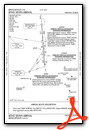
Instrument Approach Procedure (IAP) Charts
Nearby Airports with Instrument Procedures
| ID | Name | Heading / Distance | ||
|---|---|---|---|---|
 |
X21 | Arthur Dunn Air Park Airport | 273° | 7.5 |
|
KTIX | Space Coast Regional Airport | 222° | 8.2 |
|
KXMR | Cape Canaveral Space Force Station Skid Strip Airport | 142° | 11.1 |
|
KCOI | Merritt Island Airport | 178° | 16.4 |
|
KCOF | Patrick Space Force Base Airport | 168° | 23.2 |
|
X50 | Massey Ranch Airpark Airport | 330° | 24.9 |
|
KEVB | New Smyrna Beach Municipal Airport | 333° | 29.6 |
|
KSFB | Orlando Sanford International Airport | 288° | 30.1 |
|
KMLB | Melbourne Orlando International Airport | 175° | 30.8 |
|
7FL6 | Spruce Creek Airport | 326° | 33.5 |
|
KORL | Exec Airport | 263° | 34.0 |
|
KMCO | Orlando International Airport | 251° | 34.3 |
Airport Images
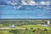
By: Gussan
By: flakeyswilson


