Login
Register


TXK
Texarkana Regional-Webb Field Airport
Official FAA Data Effective 2024-04-18 0901Z
Chart Supplement

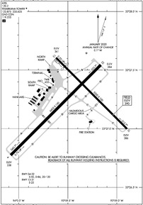
KTXK Airport Diagram
VFR Chart of KTXK
Sectional Charts at SkyVector.com
IFR Chart of KTXK
Enroute Charts at SkyVector.com
Location Information for KTXK
Coordinates: N33°27.22' / W93°59.46'Located 03 miles NE of Texarkana, Arkansas on 964 acres of land. View all Airports in Arkansas.
Surveyed Elevation is 389 feet MSL.
Operations Data
|
|
Airport Communications
| ATIS: | 120.2 |
|---|---|
| ASOS: | 120.2 Tel. 870-774-0404 |
| TEXARKANA TOWER: | 123.875 235.625 |
| TEXARKANA GROUND: | 119.225 |
| CTAF: | 123.875 |
| EMERG: | 121.5 243.0 |
| AWOS-3 at ATA (23.4 SW): | 118.250 903-799-4066 |
| ASOS at DEQ (41.0 NW): | 134.075 870-642-7829 |
| AWOS-3 at AGO (41.2 E): | 118.05 870-901-3532 |
- APCH/DEP CTL SVC PRVDD BY FORT WORTH ARTCC (ZFW) ON FREQS 123.925/269.475 (TEXARKANA RCAG).
- ATCT OPERATED BY ROBERTSON VAN BUREN ASSOCIATE INC.
Nearby Navigation Aids
|
| ||||||||||||||||||||||||||||||||||||||||||||||||||||||||||||


Runway 04/22
| Dimensions: | 6602 x 150 feet / 2012 x 46 meters | |
|---|---|---|
| Surface: | Asphalt / Grooved in Good Condition | |
| Weight Limits: | S-50, D-86, ST-120 | |
| Edge Lighting: | High Intensity | |
| Runway 04 | Runway 22 | |
| Coordinates: | N33°26.78' / W94°0.08' | N33°27.55' / W93°59.16' |
| Elevation: | 338.4 | 384.3 |
| Traffic Pattern: | Left | Left |
| Runway Heading: | 45° True | 225° True |
| Declared Distances: | TORA:6602 TODA:6602 ASDA:6602 LDA:6602 | TORA:6602 TODA:6602 ASDA:6602 LDA:6602 |
| Markings: | Precision Instrument in good condition. | Precision Instrument in good condition. |
| Glide Slope Indicator | V4L (3.00° Glide Path Angle) | |
| Approach Lights: | MALSR 1,400 Foot Medium-intensity Approach Lighting System with runway alignment indicator lights. | |
| Obstacles: | 31 ft Trees 263 ft from runway, 505 ft left of center | 17 ft Trees 358 ft from runway, 511 ft left of center |
Runway 13/31
| Dimensions: | 5200 x 100 feet / 1585 x 30 meters | |
|---|---|---|
| Surface: | Asphalt / Grooved in Good Condition | |
| Weight Limits: | S-25 | |
| Edge Lighting: | Medium Intensity | |
| Runway 13 | Runway 31 | |
| Coordinates: | N33°27.61' / W93°59.62' | N33°27.00' / W93°58.90' |
| Elevation: | 360.7 | 385.6 |
| Traffic Pattern: | Left | Left |
| Runway Heading: | 135° True | 315° True |
| Displaced Threshold: | 641 Feet | |
| Declared Distances: | TORA:5200 TODA:5200 ASDA:5200 LDA:4559 | TORA:5200 TODA:5200 ASDA:4559 LDA:4559 |
| Markings: | Non-Precision Instrument in good condition. | Non-Precision Instrument in good condition. |
| Glide Slope Indicator | P4L (3.00° Glide Path Angle) | |
| Obstacles: | 15 ft Railroad 350 ft from runway +55 FT TREE 1215 FT 475 FT LEFT. APCH RATIO 22:1 BASED ON DSPLCD THR. |
40 ft Tree 750 ft from runway, 300 ft left of center |
Services Available
| Fuel: | 100LL (blue), Jet-A |
|---|---|
| Transient Storage: | Hangars,Tiedowns |
| Airframe Repair: | MAJOR |
| Engine Repair: | MAJOR |
| Bottled Oxygen: | HIGH |
| Bulk Oxygen: | NOT AVAILABLE |
| Other Services: | AIR FREIGHT SERVICES,CHARTER SERVICE,PILOT INSTRUCTION,AIRCRAFT RENTAL,AIRCRAFT SALES |
Ownership Information
| Ownership: | Publicly owned | |
|---|---|---|
| Owner: | TEXARKANA AIRPORT AUTHORITY | FERDINAND MEHRLICH |
| 201 AIRPORT DR | ||
| TEXARKANA, AR 71854 | ||
| 870-774-2171 | ||
| Manager: | FERDINAND PAUL MEHRLICH III, CM ACE | |
| 201 AIRPORT DR | ||
| TEXARKANA, AR 71854 | ||
| 870-774-2171 | ||
Operational Statistics
| Single Engine Aircraft Based on Field: | 31 | Statistics collected for 12 month period ending 2019-12-31 | |
|---|---|---|---|
| Multi-Engine Aircraft Based on Field: | 7 | Annual Commercial Operations: | 21 |
| Jet Aircraft Based on Field: | 10 | Annual Commuter Operations: | none |
| Helicopters Based on Field: | 4 | Annual Air Taxi Operations: | 4978 |
| Military Aircraft Based on Field: | none | Annual Military Operations: | 2276 |
| Gliders Based on Field: | none | Annual GA Local Operations: | 14006 |
| Ultralights Based on Field: | none | Annual GA Itinerant Operations: | 11317 |
Other Remarks
- DEER ON & INVOF ARPT.
- FOR CD IF UNA TO CTC ON FSS FREQ, CTC FORT WORTH ARTCC AT 817-858-7584.
- BIRDS ON & INVOF ARPT.
- WHEN ATCT CLSD ACTVT MALSR RWY 22; HIRL RWY 04/22; MIRL RWY 13/31 - CTAF.
Weather Minimums

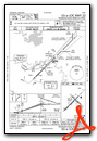
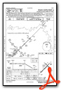
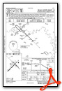
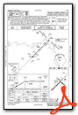
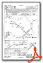
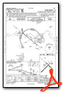
Instrument Approach Procedure (IAP) Charts
Nearby Airports with Instrument Procedures
| ID | Name | Heading / Distance | ||
|---|---|---|---|---|
 |
M18 | Hope Municipal Airport | 046° | 23.1 |
|
KATA | Hall-Miller Municipal Airport | 206° | 23.4 |
|
M77 | Howard County Airport | 013° | 33.4 |
|
3F4 | Vivian Airport | 181° | 35.5 |
|
KSPH | Springhill Airport | 133° | 40.6 |
|
KDEQ | J Lynn Helms Sevier County Airport | 330° | 41.0 |
|
KAGO | Ralph C Weiser Field Airport | 108° | 41.2 |
|
4O4 | Mc Curtain County Regional Airport | 302° | 51.3 |
|
KOSA | Mount Pleasant Regional Airport | 246° | 53.3 |
|
KDTN | Shreveport Downtown Airport | 167° | 56.1 |
|
KASL | Harrison County Airport | 196° | 58.1 |
|
KBAD | Barksdale AFB Airport | 163° | 59.4 |
Airport Images

By: bitgent
By: bitgent


