Login
Register


TZR
Bolton Field Airport
Official FAA Data Effective 2024-04-18 0901Z
Chart Supplement

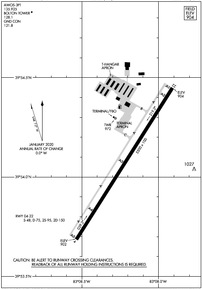
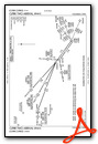
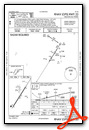
KTZR Airport Diagram
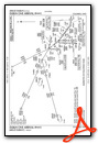
VFR Chart of KTZR
Sectional Charts at SkyVector.com
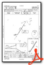
IFR Chart of KTZR
Enroute Charts at SkyVector.com
Location Information for KTZR
Coordinates: N39°54.07' / W83°8.22'Located 08 miles SW of Columbus, Ohio on 1500 acres of land. View all Airports in Ohio.
Surveyed Elevation is 904 feet MSL.
Operations Data
|
|
Airport Communications
| AWOS-3PT: | 135.925 Tel. 614-878-1722 |
|---|---|
| BOLTON TOWER: | 128.1 |
| BOLTON GROUND: | 121.8 |
| COLUMBUS APPROACH: | 132.3 ;100-279 134.0 279.6 |
| COLUMBUS DEPARTURE: | 132.3 ;100-279 134.0 279.6 |
| IC: | 134.0 279.6 |
| CTAF: | 128.100 |
| CLASS C/S: | 132.3 ;100-279 |
| CBUSS STAR: | 125.95 371.975 |
| DUBLN STAR: | 125.95 371.975 |
| AWOS-3 at LCK (10.8 SE): | 614-492-2441 |
| ATIS at LCK (11.0 SE): | 132.75 |
| ASOS at OSU (11.0 N): | 121.35 614-451-2465 |
- EMERG FREQ AVBL; NOT MONITORED ALL TIMES.
Nearby Navigation Aids
|
| ||||||||||||||||||||||||||||||||||||||||||||||||||||||||||||


Runway 04/22
| Dimensions: | 5500 x 100 feet / 1676 x 30 meters | |
|---|---|---|
| Surface: | Asphalt in Fair Condition | |
| Weight Limits: | S-48, D-75, ST-150 | |
| Edge Lighting: | Medium Intensity | |
| Runway 04 | Runway 22 | |
| Coordinates: | N39°53.69' / W83°8.53' | N39°54.45' / W83°7.90' |
| Elevation: | 901.6 | 903.6 |
| Traffic Pattern: | Left | |
| Runway Heading: | 32° True | 212° True |
| Markings: | Precision Instrument in good condition. | Precision Instrument in good condition. |
| Glide Slope Indicator | P4L (3.00° Glide Path Angle) | P4L (3.00° Glide Path Angle) |
| Approach Lights: | MALSR 1,400 Foot Medium-intensity Approach Lighting System with runway alignment indicator lights. | |
| REIL: | Yes | |
Services Available
| Fuel: | 100LL (blue), Jet A-1+ |
|---|---|
| Transient Storage: | Hangars,Tiedowns PPR CTC AMGR FOR INFO. |
| Airframe Repair: | MAJOR |
| Engine Repair: | MAJOR |
| Bottled Oxygen: | HIGH |
| Bulk Oxygen: | NONE |
| Other Services: | CHARTER SERVICE,PILOT INSTRUCTION,AIRCRAFT RENTAL,ANNUAL SURVEYING |
Ownership Information
| Ownership: | Publicly owned | |
|---|---|---|
| Owner: | COLUMBUS REGIONAL ARPT AUTH | |
| 4600 INTERNATIONAL GTWY | ||
| COLUMBUS, OH 43219-1779 | ||
| 614-239-4000 | ||
| Manager: | CHARLIE GOODWIN | |
| 2000 NORTON RD | ||
| COLUMBUS, OH 43228-3667 | ||
| 614-851-9900 | H24 EMERG OPS 614-239-4029. | |
Operational Statistics
| Single Engine Aircraft Based on Field: | 76 | Statistics collected for 12 month period ending 2022-06-07 | |
|---|---|---|---|
| Multi-Engine Aircraft Based on Field: | 6 | Annual Commercial Operations: | none |
| Jet Aircraft Based on Field: | none | Annual Commuter Operations: | none |
| Helicopters Based on Field: | 3 | Annual Air Taxi Operations: | 48 |
| Military Aircraft Based on Field: | none | Annual Military Operations: | 52 |
| Gliders Based on Field: | none | Annual GA Local Operations: | 13998 |
| Ultralights Based on Field: | none | Annual GA Itinerant Operations: | 12834 |
Other Remarks
- HIGH TENSION PLINES/TOWERS NE-SE.
- BLN & BANNER ACT ON & INVOF ARPT.
- BIRDS & OTR WILDLIFE ON & INVOF ARPT.
- FOR FUEL & ACFT SVCS CTC FBO ON 123.3.
- FOR CD WHEN ATCT IS CLSD CTC COLUMBUS APCH AT 614-338-8537.
- CALM WIND RWY.
- 0LL 100LL AVBL H24 SELF SVC VIA CREDIT CARD.
- WHEN ATCT CLSD ACTVT MALSR RWY 04; REIL RWY 22; MIRL RWY 04/22 - CTAF.
Weather Minimums

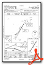
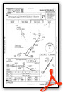
Standard Terminal Arrival (STAR) Charts
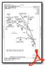
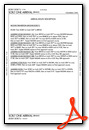
Instrument Approach Procedure (IAP) Charts
Nearby Airports with Instrument Procedures
| ID | Name | Heading / Distance | ||
|---|---|---|---|---|
 |
KLCK | Rickenbacker International Airport | 118° | 11.0 |
|
KOSU | Ohio State University Airport | 015° | 11.1 |
|
KCMH | John Glenn Columbus International Airport | 062° | 12.7 |
|
KUYF | Madison County Airport | 277° | 15.1 |
|
KMRT | Union County Airport | 333° | 21.8 |
|
KDLZ | Delaware Municipal/Jim Moore Field Airport | 002° | 22.7 |
|
KLHQ | Fairfield County Airport | 111° | 23.8 |
|
I23 | Fayette County Airport | 213° | 23.8 |
|
KCYO | Pickaway County Memorial Airport | 162° | 24.2 |
|
KRZT | Ross County Airport | 169° | 28.1 |
|
I74 | Grimes Field Airport | 296° | 31.6 |
|
KVTA | Newark-Heath Airport | 076° | 32.0 |
Airport Images

By: Big Orange Bird


