Login
Register


U76
Mountain Home Municipal Airport
Official FAA Data Effective 2024-04-18 0901Z
Chart Supplement

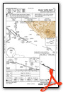
VFR Chart of U76
Sectional Charts at SkyVector.com
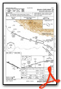
IFR Chart of U76
Enroute Charts at SkyVector.com
Location Information for U76
Coordinates: N43°7.90' / W115°43.83'Located 02 miles W of Mountain Home, Idaho on 443 acres of land. View all Airports in Idaho.
Surveyed Elevation is 3166 feet MSL.
Operations Data
|
|
Airport Communications
| MOUNTAIN HOME APPROACH: | 124.8 259.1 |
|---|---|
| MOUNTAIN HOME DEPARTURE: | 124.8 259.1 |
| UNICOM: | 122.800 |
| CTAF: | 122.800 |
| ATIS at MUO (8.2 SW): | 273.5 |
| D-ATIS at BOI (33.7 NW): | 123.9 |
| ASOS at BOI (33.7 NW): | 208-388-4640 |
- APCH/DEP CTL SVC PRVDD BY SALT LAKE ARTCC (ZLC) ON FREQS 118.05/363.0 (BLISS RCAG) WHEN MOUNTAIN HOME APCH CTL CLSD.
Nearby Navigation Aids
|
| ||||||||||||||||||||||||||||||||||||||||||||||||


Runway 10/28
| Dimensions: | 5000 x 75 feet / 1524 x 23 meters | |
|---|---|---|
| Surface: | Asphalt in Excellent Condition | |
| Weight Limits: | S-42, D-53 | |
| Edge Lighting: | Medium Intensity | |
| Runway 10 | Runway 28 | |
| Coordinates: | N43°8.08' / W115°44.34' | N43°7.71' / W115°43.33' |
| Elevation: | 3166.6 | 3157.8 |
| Traffic Pattern: | Left | Left |
| Runway Heading: | 116° True | 296° True |
| Markings: | Non-Precision Instrument in good condition. | Non-Precision Instrument in good condition. |
| Glide Slope Indicator | P2L (3.00° Glide Path Angle) | P2L (3.00° Glide Path Angle) |
| REIL: | Yes | Yes |
| Obstacles: | 50 ft Power Line 1400 ft from runway | |
Services Available
| Fuel: | 100LL (blue), Jet-A |
|---|---|
| Transient Storage: | Tiedowns |
| Airframe Repair: | MAJOR |
| Engine Repair: | MAJOR |
| Bottled Oxygen: | NONE |
| Bulk Oxygen: | NONE |
| Other Services: | CROP DUSTING SERVICES,PILOT INSTRUCTION,AIRCRAFT RENTAL |
Ownership Information
| Ownership: | Publicly owned | |
|---|---|---|
| Owner: | CITY OF MOUNTAIN HOME | |
| PO BOX 10 | ||
| MOUNTAIN HOME, ID 83647 | ||
| 208-587-2104 | ||
| Manager: | THOMAS HOEGG | CLETIS HOLDEN: 208-254-1953 / INFO@CKAVIATIONSERVICES.COM |
| 2614 AIRBASE RD | ||
| MOUNTAIN HOME, ID 83647 | ||
| 208-599-0609 | ALT CTC CELL 208-598-1653. | |
Operational Statistics
| Single Engine Aircraft Based on Field: | 17 | Statistics collected for 12 month period ending 2018-02-09 | |
|---|---|---|---|
| Multi-Engine Aircraft Based on Field: | 1 | Annual Commercial Operations: | none |
| Jet Aircraft Based on Field: | none | Annual Commuter Operations: | none |
| Helicopters Based on Field: | 1 | Annual Air Taxi Operations: | none |
| Military Aircraft Based on Field: | none | Annual Military Operations: | 1500 |
| Gliders Based on Field: | none | Annual GA Local Operations: | 10000 |
| Ultralights Based on Field: | none | Annual GA Itinerant Operations: | 6000 |
Other Remarks
- HIGH PERFORMANCE MIL JET OPNS CONDUCTED AT MOUNTAIN HOME AFB 8 NM SW OF ARPT.
- EXTENSIVE AGRICULTURAL OPERATIONS.
- 0LL 100LL AVBL 24 HRS WITH CREDIT CARD.
- JET A AVBL 24 HRS WITH CREDIT CARD. JET A SINGLE POINT AVBL MON-FRI 1500-0100Z OR BY APPOINTMENT CALL (208) 587-3585.
- ACTVT REIL RWY 10 & 28; PAPI RWY 10 & 28; MIRL RWY 10/28 - CTAF.
- AUTOMATED UNICOM.
Weather Minimums
Instrument Approach Procedure (IAP) Charts
Departure Procedure Obstacles (DPO) Charts
Nearby Airports with Instrument Procedures
| ID | Name | Heading / Distance | ||
|---|---|---|---|---|
 |
KMUO | Mountain Home AFB Airport | 229° | 8.2 |
|
KBOI | Boise Air Trml/Gowen Field Airport | 320° | 33.7 |
|
KMAN | Nampa Municipal Airport | 308° | 43.9 |
|
KGNG | Gooding Municipal Airport | 106° | 44.3 |
|
KEUL | Caldwell Exec Airport | 308° | 50.1 |
|
KJER | Jerome County Airport | 112° | 61.2 |
|
KSUN | Friedman Memorial Airport | 069° | 66.7 |
|
KTWF | Joslin Field/Magic Valley Regional Airport | 124° | 67.3 |
|
10U | Owyhee Airport | 195° | 73.4 |
|
KONO | Ontario Municipal Airport | 314° | 77.2 |
|
S87 | Weiser Municipal Airport | 320° | 83.7 |
|
KBYI | Burley Municipal Airport | 111° | 93.4 |
Airport Images
Do you have a recent image of this airport? Upload it here!


