Login
Register


ULM
New Ulm Municipal Airport
Official FAA Data Effective 2024-04-18 0901Z
Chart Supplement

VFR Chart of KULM
Sectional Charts at SkyVector.com
IFR Chart of KULM
Enroute Charts at SkyVector.com
Location Information for KULM
Coordinates: N44°19.10' / W94°30.10'Located 02 miles W of New Ulm, Minnesota on 195 acres of land. View all Airports in Minnesota.
Surveyed Elevation is 1011 feet MSL.
Operations Data
|
|
Airport Communications
| AWOS-3: | 118.325 Tel. 507-359-1656 |
|---|---|
| CTAF: | 123.000 |
| UNICOM: | 123.000 |
| AWOS-3PT at JYG (20.3 S): | 123.7 507-375-7105 |
| AWOS-3PT at MKT (25.8 E): | 118.175 507-625-3726 |
| ASOS at RWF (28.4 NW): | 126.575 507-644-3564 |
- APCH/DEP SVC PRVDD BY MINNEAPOLIS ARTCC ON FREQS 127.1/290.2 (REDWOOD FALLS RCAG).
Nearby Navigation Aids
|
| ||||||||||||||||||||||||||||||||||||||||||||||||||||||


Runway 15/33
| Dimensions: | 5401 x 100 feet / 1646 x 30 meters | |
|---|---|---|
| Surface: | Asphalt / Grooved in Good Condition | |
| Edge Lighting: | Medium Intensity | |
| Runway 15 | Runway 33 | |
| Coordinates: | N44°19.44' / W94°30.38' | N44°18.67' / W94°29.78' |
| Elevation: | 1005.0 | 1003.2 |
| Runway Heading: | 151° True | 331° True |
| Markings: | Non-Precision Instrument in good condition. | Non-Precision Instrument in good condition. |
| Glide Slope Indicator | P4L (3.00° Glide Path Angle) | P4R (3.00° Glide Path Angle) |
| Approach Lights: | MALSF 1,400 Foot Medium-intensity Approach Lighting System with sequenced flashers. | |
| REIL: | Yes | |
Runway 04/22
CLSD WINTER MONTHS. | ||
| Dimensions: | 2478 x 160 feet / 755 x 49 meters | |
|---|---|---|
| Surface: | Turf in Good Condition | |
| Runway 04 | Runway 22 | |
| Coordinates: | N44°19.07' / W94°30.35' | N44°19.34' / W94°29.92' |
| Elevation: | 1003.4 | 1001.2 |
| Traffic Pattern: | Left | Left |
| Runway Heading: | 49° True | 229° True |
Services Available
| Fuel: | 100LL (blue), Jet-A |
|---|---|
| Transient Storage: | Hangars,Tiedowns |
| Airframe Repair: | MAJOR |
| Engine Repair: | MAJOR |
| Bottled Oxygen: | NONE |
| Bulk Oxygen: | NONE |
Ownership Information
| Ownership: | Publicly owned | |
|---|---|---|
| Owner: | CITY OF NEW ULM | |
| 100 N BROADWAY, PO BOX 636 | ||
| NEW ULM, MN 56073-0636 | ||
| 507-359-8245 | ||
| Manager: | BRYAN CHRISTENSEN | |
| 1617 HIGHWAY 14 W | ||
| NEW ULM, MN 56073-2331 | ||
| 507-354-4337 | OR 507-354-8127. | |
Operational Statistics
| Single Engine Aircraft Based on Field: | 11 | Statistics collected for 12 month period ending 2018-04-30 | |
|---|---|---|---|
| Multi-Engine Aircraft Based on Field: | 2 | Annual Commercial Operations: | none |
| Jet Aircraft Based on Field: | none | Annual Commuter Operations: | none |
| Helicopters Based on Field: | none | Annual Air Taxi Operations: | 4500 |
| Military Aircraft Based on Field: | none | Annual Military Operations: | 10 |
| Gliders Based on Field: | none | Annual GA Local Operations: | 4500 |
| Ultralights Based on Field: | none | Annual GA Itinerant Operations: | 6500 |
Other Remarks
- GCO AVBL ON FREQ 121.725 THRU MINNEAPOLIS ARTCC & FLT SVCS.
- FOR CD IF UNA VIA GCO CTC MINNEAPOLIS ARTCC AT 651-463-5588.
- YELLOW CONES.
- YELLOW CONES.
- 0LL FUEL AVBL H24 VIA CREDIT CARD.
- ACTVT MALSF RWY 33; REIL RWY 15; PAPI RWY 15 & 33; MIRL RWY 15/33 - CTAF.
Weather Minimums
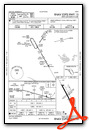
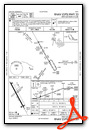
Instrument Approach Procedure (IAP) Charts
Nearby Airports with Instrument Procedures
| ID | Name | Heading / Distance | ||
|---|---|---|---|---|
 |
KJYG | St James Municipal Airport | 186° | 20.1 |
|
D42 | Springfield Municipal Airport | 256° | 22.1 |
|
KMKT | Mankato Regional Airport | 102° | 25.8 |
|
KRWF | Redwood Falls Municipal Airport | 298° | 28.5 |
|
KGYL | Glencoe Municipal Airport | 034° | 31.9 |
|
KHCD | Hutchinson Municipal/Butler Field Airport | 008° | 32.9 |
|
KMWM | Windom Municipal Airport | 227° | 35.8 |
|
KOVL | Olivia Regional Airport | 320° | 35.8 |
|
KFRM | Fairmont Municipal Airport | 174° | 40.6 |
|
KACQ | Waseca Municipal/Maynard Richard Stensrud Field Airport | 109° | 43.5 |
|
KMJQ | Jackson Municipal Airport | 207° | 45.2 |
|
KLJF | Litchfield Municipal Airport | 359° | 46.7 |
Airport Images
Do you have a recent image of this airport? Upload it here!


