Login
Register


UYF
Madison County Airport
Official FAA Data Effective 2024-04-18 0901Z
Chart Supplement

VFR Chart of KUYF
Sectional Charts at SkyVector.com
IFR Chart of KUYF
Enroute Charts at SkyVector.com
Location Information for KUYF
Coordinates: N39°55.96' / W83°27.72'Located 03 miles N of London, Ohio on 148 acres of land. View all Airports in Ohio.
Surveyed Elevation is 1081 feet MSL.
Operations Data
|
|
Airport Communications
| AWOS-3PT: | 120.85 Tel. 740-852-2844 |
|---|---|
| COLUMBUS APPROACH: | 134.0 279.6 |
| COLUMBUS DEPARTURE: | 134.0 279.6 |
| CTAF: | 123.000 |
| UNICOM: | 123.000 |
| AWOS-3PT at TZR (15.1 E): | 135.925 614-878-1722 |
| AWOS-3 at I74 (18.0 NW): | 118.325 937-484-5863 |
| AWOS-3 at MRT (18.2 N): | 119.275 937-644-2967 |
Nearby Navigation Aids
|
| ||||||||||||||||||||||||||||||||||||||||||||||||||||||||||||


Runway 09/27
| Dimensions: | 4000 x 75 feet / 1219 x 23 meters | |
|---|---|---|
| Surface: | Asphalt / Grooved in Excellent Condition | |
| Weight Limits: | S-30, D-40 | |
| Edge Lighting: | Medium Intensity | |
| Runway 09 | Runway 27 | |
| Coordinates: | N39°55.94' / W83°28.15' | N39°55.98' / W83°27.29' |
| Elevation: | 1081.5 | 1051.0 |
| Traffic Pattern: | Left | Left |
| Runway Heading: | 87° True | 267° True |
| Markings: | Non-Precision Instrument in good condition. | Non-Precision Instrument in good condition. |
| Glide Slope Indicator | P4L (3.00° Glide Path Angle) | P4L (3.00° Glide Path Angle) |
| REIL: | Yes | Yes |
| Obstacles: | 7 ft Tree 228 ft from runway, 236 ft right of center +3-12 FT BRUSH/TREES, 60-200 FT DIST, 175 FT R. |
|
Services Available
| Fuel: | 100LL (blue), Jet-A |
|---|---|
| Transient Storage: | Hangars,Tiedowns PRIOR CDN RQRD. |
| Airframe Repair: | NONE |
| Engine Repair: | NONE |
| Bottled Oxygen: | NONE |
| Bulk Oxygen: | NONE |
Ownership Information
| Ownership: | Publicly owned | |
|---|---|---|
| Owner: | MADISON COUNTY AIRPORT AUTH | |
| 1281 US HIGHWAY 40 SW | ||
| LONDON, OH 43140-9213 | ||
| 740-852-5040 | ||
| Manager: | JOHN DUHL | |
| 1281 US HIGHWAY 40 SW | ||
| LONDON, OH 43140-9213 | ||
| 740-852-5040 | ||
Operational Statistics
| Single Engine Aircraft Based on Field: | 36 | Statistics collected for 12 month period ending 2023-06-28 | |
|---|---|---|---|
| Multi-Engine Aircraft Based on Field: | 4 | Annual Commercial Operations: | none |
| Jet Aircraft Based on Field: | none | Annual Commuter Operations: | none |
| Helicopters Based on Field: | 1 | Annual Air Taxi Operations: | 60 |
| Military Aircraft Based on Field: | none | Annual Military Operations: | 2100 |
| Gliders Based on Field: | none | Annual GA Local Operations: | 21000 |
| Ultralights Based on Field: | none | Annual GA Itinerant Operations: | 18250 |
Other Remarks
- FOR CD CTC COLUMBUS APCH AT 614-338-8537.
- 0LL FUEL AVBL H24 SELF SER.
- ACTVT REIL RWY 09 & 27; MIRL RWY 09/27 - CTAF. PAPI RWY 09 & 27 OPR CONSLY.
Weather Minimums

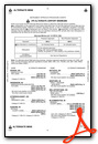
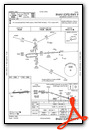
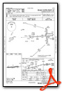
Instrument Approach Procedure (IAP) Charts
Nearby Airports with Instrument Procedures
| ID | Name | Heading / Distance | ||
|---|---|---|---|---|
 |
KTZR | Bolton Field Airport | 097° | 15.1 |
|
I74 | Grimes Field Airport | 311° | 18.0 |
|
KMRT | Union County Airport | 016° | 18.2 |
|
KSGH | Springfield/Beckley Municipal Airport | 252° | 18.3 |
|
KOSU | Ohio State University Airport | 063° | 20.0 |
|
I23 | Fayette County Airport | 174° | 21.8 |
|
KLCK | Rickenbacker International Airport | 105° | 25.7 |
|
KDLZ | Delaware Municipal/Jim Moore Field Airport | 037° | 26.3 |
|
KCMH | John Glenn Columbus International Airport | 081° | 26.6 |
|
KFFO | Wright-Patterson AFB Airport | 256° | 27.7 |
|
KGDK | Greene County/Lewis A Jackson Regional Airport | 239° | 28.5 |
|
KEDJ | Bellefontaine Regional Airport | 328° | 31.1 |
Airport Images
Do you have a recent image of this airport? Upload it here!


