Login
Register


VIS
Visalia Municipal Airport
Official FAA Data Effective 2024-03-21 0901Z
Chart Supplement

VFR Chart of KVIS
Sectional Charts at SkyVector.com
IFR Chart of KVIS
Enroute Charts at SkyVector.com
Location Information for KVIS
Coordinates: N36°19.12' / W119°23.57'Located 04 miles W of Visalia, California on 821 acres of land. View all Airports in California.
Surveyed Elevation is 292 feet MSL.
NO DOWNWIND TURNS WHEN DEPARTING RWY 12 UNTIL RCHG TFC PAT ALT.
Operations Data
|
|
Airport Communications
| AWOS-3PT: | 119.925 Tel. 559-651-2418 |
|---|---|
| FRESNO APPROACH: | 118.5 |
| FRESNO DEPARTURE: | 118.5 |
| CLEARANCE DELIVERY: | 118.5 |
| CTAF: | 123.050 |
| UNICOM: | 123.050 |
| AWOS-3PT at TLR (10.0 S): | 120.0 559-686-2613 |
| ASOS at HJO (11.2 W): | 134.75 559-585-8076 |
| AWOS-3PT at O32 (21.2 N): | 120.175 559-637-9453 |
Nearby Navigation Aids
|
| ||||||||||||||||||||||||||||||||||||||||||||||||


Runway 12/30
| Dimensions: | 6562 x 150 feet / 2000 x 46 meters | |
|---|---|---|
| Surface: | Asphalt / Porous Friction Course in Good Condition | |
| Weight Limits: | S-60, D-100, ST-160 | |
| Edge Lighting: | High Intensity | |
| Runway 12 | Runway 30 | |
| Coordinates: | N36°19.50' / W119°24.05' | N36°18.74' / W119°23.10' |
| Elevation: | 288.7 | 292.5 |
| Traffic Pattern: | Left | |
| Runway Heading: | 135° True | 315° True |
| Displaced Threshold: | 917 Feet | |
| Declared Distances: | TORA:6560 TODA:7560 ASDA:6560 LDA:5635 | TORA:5635 TODA:6635 ASDA:5635 LDA:5635 |
| Markings: | Non-Precision Instrument in good condition. | Precision Instrument in good condition. |
| Glide Slope Indicator | P4L (3.00° Glide Path Angle) | P4L (3.00° Glide Path Angle) |
| Approach Lights: | MALSR 1,400 Foot Medium-intensity Approach Lighting System with runway alignment indicator lights. | |
| REIL: | Yes | |
| Obstacles: | 4 ft Fence 200 ft from runway, 250 ft right of center APCH RATIO 20:1 TO DSPLCD THLD. |
61 ft Tree 3175 ft from runway, 725 ft right of center |
Helipad H1
| Dimensions: | 45 x 45 feet / 14 x 14 meters | |
|---|---|---|
| Surface: | Concrete in Good Condition | |
| Weight Limits: | S-18, D-45, ST-90 | |
| Coordinates: | N36°19.52' / W119°23.95' | N0°0.00' / E0°0.00' |
| Elevation: | 294.5 | |
| Markings: | Basic in good condition. | |
Services Available
| Fuel: | 100LL (blue), Jet-A |
|---|---|
| Transient Storage: | Tiedowns |
| Airframe Repair: | MAJOR |
| Engine Repair: | MAJOR |
| Bottled Oxygen: | NONE |
| Bulk Oxygen: | NONE |
| Other Services: | AVIONICS,CHARTER SERVICE,PILOT INSTRUCTION,AIRCRAFT RENTAL |
Ownership Information
| Ownership: | Publicly owned | |
|---|---|---|
| Owner: | CITY OF VISALIA | |
| CITY HALL, 707 WEST ACEQUIA | ||
| VISALIA, CA 93291 | ||
| 559-713-4201 | ||
| Manager: | JODY MILLER | EMAIL: JODY.MILLER@VISALIA.CITY |
| 9501 ARPT DRIVE | ||
| VISALIA, CA 93277 | ||
| (559) 713-4282 | ||
Operational Statistics
| Single Engine Aircraft Based on Field: | 120 | Statistics collected for 12 month period ending 2023-09-22 | |
|---|---|---|---|
| Multi-Engine Aircraft Based on Field: | 36 | Annual Commercial Operations: | none |
| Jet Aircraft Based on Field: | 2 | Annual Commuter Operations: | none |
| Helicopters Based on Field: | 2 | Annual Air Taxi Operations: | 1000 |
| Military Aircraft Based on Field: | none | Annual Military Operations: | 500 |
| Gliders Based on Field: | 1 | Annual GA Local Operations: | 6000 |
| Ultralights Based on Field: | none | Annual GA Itinerant Operations: | 25000 |
Other Remarks
- RY 30 DESIGNATED CALM WIND RY.
- RON TIEDOWN FEE.
- HELIPAD ON PARALLEL TWY; THEN HOVERTAXI TO ADJACENT CONCRETE PARKING PAD; 20000 LBS MAX WGT.
- 0LL SELF-SERVICE FUEL 100LL AVBL 24 HRS.
- SELF-SERVICE FUEL JET A AVBL 24HRS.
- ACTVT MALSR RWY 30; REIL RWY 12; PAPI RWY 12 & 30; HIRL RWY 12/30 - CTAF.
- NO DOWNWIND TURNS WHEN DEPARTING RWY 12 UNTIL RCHG TFC PAT ALT.
Weather Minimums
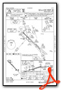
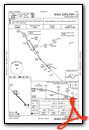
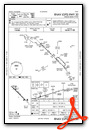
Instrument Approach Procedure (IAP) Charts
Nearby Airports with Instrument Procedures
| ID | Name | Heading / Distance | ||
|---|---|---|---|---|
 |
KTLR | Mefford Field Airport | 161° | 10.2 |
|
KHJO | Hanford Municipal Airport | 269° | 11.4 |
|
O32 | Reedley Municipal Airport | 352° | 21.3 |
|
KPTV | Porterville Municipal Airport | 137° | 23.6 |
|
KFAT | Fresno Yosemite International Airport | 330° | 31.6 |
|
KFCH | Fresno Chandler Exec Airport | 320° | 32.3 |
|
KDLO | Delano Municipal Airport | 167° | 35.2 |
|
C80 | New Coalinga Municipal Airport | 258° | 44.8 |
|
KMIT | Shafter-Minter Field Airport | 168° | 49.6 |
|
KMAE | Madera Municipal Airport | 319° | 53.1 |
|
KBFL | Meadows Field Airport | 162° | 55.5 |
|
F34 | Firebaugh Airport | 302° | 61.1 |


